

Plan on construction of Gia Lai province region to 2035 with a vision to 2050
Wednesday, February 28,2018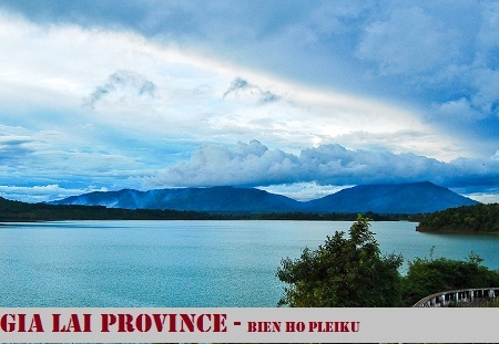
AsemconnectVietnam - To build and develop Gia Lai province up to 2035 with a vision to 2050 to become a center of the North Central Highlands and a dynamic region in development triangle of Vietnam, Laos and Cambodia, having integrated and modern infrastructure
Planning boundary of Gia Lai province covers entire administrative boundary of Gia Lai province with an area of about 15,510.99 km2, including 17 district-level administrative units: Pleiku city; An Khe town, Ayun Pa town and districts of K'Bang, Dak Doa, Chu Pah, Ia Grai, Mang Yang, Kong Chro, Duc Co, Chu Prong, Chu Se, Dak Po, Ia Pa, Krong Pa, Phu Thien, Chu Puh, boundaries are determined as follows:
- The East borders provinces of Quang Ngai, Binh Dinh and Phu Yen;
- The West borders Cambodia;
- The south borders Dak Lak province;
- The north borders Kon Tum province.
2. Objectives and characteristics
a) Objectives
- To build and develop Gia Lai province up to 2035 with a vision to 2050 to become a center of the North Central Highlands and a dynamic region in development triangle of Vietnam, Laos and Cambodia, having integrated and modern infrastructure.
- To specify plan objectives of the country, the Central Highlands, the socio-economic master plan and the integrated plan of branches and sectors of Gia Lai province.
- To associate socio-economic development with the protection of national security and defense, natural resources and ecological environment, preserve the typical cultural identities of ethnic groups in association with goal of stabilizing land, ethnic groups and religion in the province of Gia Lai in particular and the Central Highlands in general.
- To organize functional zoning to maximize potential advantages of location and natural resources, focus on developing key economic sectors of the province such as:
+ Agriculture - forestry: To expand area, raise productivity, produce food and cattle raising in East Truong Son economic zone; To develop industrial crops of high economic value such as rubber, tea and coffee ... in association with agricultural commodity processing industry for export in West Truong Son economic zone;
+ Developing concentrated industrial zones; to maintain exploitation of high-efficiency hydropower plants and exploit minerals in association with protection of ecological environment, especially protection of forests and water sources of system of lakes, rivers and streams;
+ To develop trade and service in Pleiku city, An Khe town, Ayun Pa town, Chu Se town; trade and economic exchange, transshipment of goods and services at Le Thanh international border gate.
- To identify infrastructure spaces for specific functional areas such as eco-tourism; cultural and historical tourism in order to create favorable conditions for tourism development while preserving natural, ecological, cultural and historical landscapes.
- To supplement rational development of system of urban centers and rural residential areas throughout the province, focusing on urban development in Pleiku city and An Khe town, Ayun Pa township and Chu Sse township to creating a close link to promote sustainable development.
- Orientations for elaboration of specialized plans and functional quarters in the whole province. Identifying priority investment projects and programs to create regional development motives;
- To identify areas where construction is banned, conservation zones.
b) Properties:
- Being a center of north Central Highlands and dynamic regions, centers of trade, goods transshipment and commercial services in development triangle of countries of Vietnam, Laos and Cambodia;
- Being a general economic zone, including border-gate economic, agricultural-forestry, industrial economic, cultural and historical-ecological tourism in association with preservation of natural landscapes;
- It is a watershed protection zone, a buffer zone for the South Central coastal area, protecting national biodiversity and the Central Highlands region;
- Being a cultural festival center of the North Central Highlands, preserving typical cultural values;
- It is an important strategic location for national defense and security in the Central Highlands and the country.
a) Population:
- By the year 2025, total amount of population of the whole province shall be around 1,580,000 persons with an urbanization rate of around 35%.
- By the year 2035, the population will be about 1,850,000 persons, the urbanization rate will be about 45%.
- Forecast of tourists: By 2025 about 750,000 visitors, by 2035 about 3 million visitors, growth rate of tourists on average will be 15 - 18% per year.
b) Regarding land:
- It is estimated that amount of urban construction land will reach around 10,200 - 10,500 hectares by 2025 and about 12,000 - 13,500 hectares by 2035, 15,500 - 16,500 hectares by 2050.
(Forecasts on population size, land will be specified during planning study).
a) Position of regional relations:
- Study on impact of the region: Identify sectors and fields that have an impact on role and position of Gia Lai province in international relations, the Central Highlands, the border areas of Vietnam and Cambodia, South Central Coast region in national defense and security and socio-economic development strategies;
- Assessing natural characteristics. Assessing natural hazards (if any), impact of climate change factors on socio-economic development in Gia Lai province.
- Evaluating potential of the land fund for construction, classifying favorable and unfavorable and forbidding construction zones which bases on analysis and assessment of negative and positive effects of natural conditions.
- To identify potential areas for construction land fund to exploit construction of functional zones, infrastructure focal points, urban systems and rural population quarters to create a motive force for socio economic development and development of fields.
- Evaluating projects and projects on hydropower, solar and wind energy. Analyzing positive and negative impacts on socio-economic development and ecological environment of Gia Lai province region. Especially impact of energy projects on role of "watershed protection, buffer zone for the South Central coastal area, protection of biodiversity in the country and the Central Highlands".
- To review generally potential and resources for development; shortcomings and inadequacies of regional development; Assess current situation and supplement content which are suitable with realities of socio-economic development in Gia Lai province.
d/ To evaluate results of implementation of socio-economic plan schemes, specialized plans and effective plans of Gia Lai province. Evaluating specialized plans on urban centers, rural areas, economic infrastructures and technical infrastructures, etc., to address issues to be addressed in the plan.
e) To define vision and regional development objectives: To identify future development contexts for international regions, national regions, Vietnam - Cambodia border areas, the Central Highlands and the South Central Coast region; Defining role of Gia Lai province in regional relations; identify development objectives, speed up urbanization of the region; identify potential, characteristics and dynamics of the region.
g) Spatial development orientations for the provincial region:
- To propose spatial development of Gia Lai province region in accordance with socio-economic development zones of Gia Lai province, Central Highlands.
- To propose allocation of industrial zones; distribution of tourism areas - landscape areas - nature conservation zones; distribution of agro-forestry-fishery areas; Proposing distribution of social infrastructure and trade in services, such as education and training, health care, culture and sport, trade and services.
- Propose regional development framework, distribution of dynamic economic regions, such as: urban areas, concentrated industrial zones, eco-tourism areas, major agro-forestry areas; Proposing formation of key areas for eco-tourism and cultural-historical tourism; agro-forest product processing industry, agricultural areas, natural landscape and natural resource protection zones, and national and regional natural resources, meeting requirements of responding to climate change. Determining size of conservation areas, forest protection, water sources, biodiversity and landscape environment.
To propose to organize urban space system, list of upgraded and expanded urban centers, urban centers, classification of urban centers, choosing morphology, structure, nature, functions and sizes of urban centers. Identify roles and principles of development; subregional dynamics cities; Specialized urban centers which associates with eco-tourism areas and industrial parks. Preliminary determinating spatial development direction of cities and towns in the region, main economic-urban centers, regional centers and sub-regions, specialized urban centers in association with protection of natural resources to ensure the maximum exploitation of the potential and advantages of the province's natural conditions and the main technical infrastructure system; ensure urban-rural linkages.
- To study and determine orientations for development of rural areas: To develop rural population in association with agricultural production areas, ensuring preservation of cultural identities. To combine rural development with urbanization process, creating a driving force for the development of a number of rural population areas in direction of formulating urban centers of grade V; Connect with existing urban areas, provincial infrastructure systems, tourism areas, trade centers.
h / Orientations for distribution and determination of scale of network of socio-economic infrastructures include large-scale, regional education, training, cultural, health and physical training and sport centers; trade centers; tourist center, resort; area of protection of natural landscapes, environment and cultural and historical relics of regional and national value. For specific functional areas, specialized centers must be identified according to specific functions. In areas of international economic corridors and inter-provincial economic corridors, system of public centers along the route must be identified.
Placement of regional training centers; national tourism center.
Propose areas or resorts which associate with protection of natural areas.
- Traffic:
Determining traffic frames, traffic works in the whole province, linking urban centers and key investment areas in the province, linking the region with the national traffic hub on the basis of stepping up the inter- between regions in the province and between Gia Lai province and neighboring provinces; Propose the scale and route of corridors of international, national and intra-provincial transport corridors to increase the efficiency of new land fund exploitation in districts, linking Le Thanh border economic zone, industrial with urban centers of the province. To propose the development of traffic systems linking Gia Lai province with important urban centers in the Central Highlands, Ho Chi Minh City, the South Central Coast and the Vietnam-Cambodia border region. Main transportation routes such as National Highway 14, 19, 25; Ho Chi Minh road, Truong Son Dong road, Pleiku airport ... Proposed external transportation network including roads, airways, railways.
- Technical preparation of construction land:
Determining the solutions to exploit the land fund to build and warning the exploitation of land funds in geological areas is not favorable. Solutions to create land fund for the construction of urbanized areas, industrial concentration; high-tech agricultural production areas, flood control measures, geohazards ... combined with irrigation and drainage systems of the region. Analysis and evaluation of topography, climate change, geological changes: earthquakes, subsidence, slides, erosion of mountains, rivers, streams, warning of restricted areas and construction constraints. Solutions on leveling, drainage, prevention and treatment of geological changes, floods. Determining the altitude of the urban centers. Notes to integrate with climate change scenarios. Identification of basins, main drainage directions. Update the irrigation planning of the study area.
- Water supply:
Determining water reserve in the area; Applicable norms and standards; Comprehensive forecast of water use needs; Water supply solutions; Determining the scale of key works; Solutions on water source protection. Study on water supply solutions suitable with the characteristics of the region, suitable to climate change conditions.
- Power supply:
Determining the electricity demand of the whole province, proposing solutions to arrange power supply works and networks of high voltage lines; Study recommends other natural energy sources.
- Waste water drainage, solid waste management (CRT), cemetery:
Identification of norms and demands for wastewater, solid waste and cemetery land by city grade; Forecasting the total volume of wastewater, solid waste, the need of the cemetery land; The main solutions are sewage, solid waste, cemetery.
k) Strategic Environmental Assessment
Identification of major environmental issues; analyzing and assessing the current status of major pollution sources, degraded areas, landscape ecological zones; forecast trends of environmental issues due to the impact of the preparation and implementation of planning; environmental zoning orientation; environmental protection strategy; Locate areas that need to protect water sources, isolate areas such as rubbish dumps, cemeteries ... If the overall solutions and management mechanisms to control, minimize and handle the impacts harmful to the environment. Research on integrating strategic environmental assessment into regional spatial planning.
l / Regional priority investment development programs.
- Proposing the program on urban system development, the program on sedentarization, rearrangement of population in erosion and remote areas, building new rural areas, urban drainage and sewerage system, forestation and development program, protection forest, special use forest, landscape forest, national park. Urban Development Projects; service trade centers; Ecotourism projects.
- Infrastructure programs: To develop provincial roads linking national roads; To upgrade the transport system to increase the connectivity between urban centers and rural areas, to upgrade the central and regional central backbone roads, the provincial roads and the adjacent ones, prioritizing the development of regional highways; Building a regional energy supply network; Development of water supply system throughout the region.
- Programs to improve the quality of life for environmental protection: urban space development in central and sub-regions; development of national and regional public service works; Control programs for environmental protection, water source protection; programs for the development of tourist resorts; historical and cultural tourism; Housing development program for low-income people and industrial parks.
m) Regional construction management requirements: Recommend incentive schemes; on state management; planning for regional planning; Establishment of regional management regulations.
n) Solutions and organization of implementation of the plan: Solutions on mobilizing capital sources; human resources development; measures on strengthening of cooperation among localities in Gia Lai province and other localities in the Central Highlands, Ho Chi Minh City, the South Central Coast and the Vietnam-Cambodia border region; Proposals for implementation.
Long Giang
Source: Vitic/ thuvienphapluat.vn
Program on conservation and development of Vietnamese craft villages in a period of 2021 - 2030
Implementation plan of marine aquaculture development project in Ninh Binh province to 2030 with a vision to 2045
Plan on implementing national environmental protection strategy to 2030 with a vision to 2050 in Kien Giang province
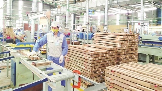
Plan on implementing Decision No. 327/QD-TTG dated March 10, 2022 of the Prime Minister approving the project on developing sustainable and effective wood processing industry in the period of 2021-2030 in Gia Lai province
Action plan on implementing strategy of sustainable agricultural and rural development in a period of 2022-2030 with a vision to 2050 in Hanoi city
Plan on implementing Decision No.923/QD-TTG dated August 2, 2022 of the Prime Minister approving science and technology program for new rural construction in a period of 2021-2025 in Vinh Long province
Plan on implementing strategy of sustainable agricultural and rural development in Bac Kan province in a period of 2021 - 2030 with a vision to 2050
Action plan on implementing livestock development strategy in a period of 2022-2030 with a vision to 2045 in Hanoi city
Implementation plan of Vietnam's forestry development strategy for a period of 2021-2030 with a vision to 2050 in Gia Lai province
National master plan in a period of 2021-2030, vision to 2050
Program on strengthening environmental protection, food safety and rural clean water supply in building new countryside in a period of 2021-2025
Digital transformation program on building new countryside, towards smart new countryside in a period of 2021 - 2025
Rural tourism development program on new rural construction in a period of 2021 - 2025
Project on development of trade, e-commerce systems and border trade in Binh Phuoc province in a period of 2021-2025, orientation to 2030
Plan on implementing Decision No. 327/QD-TTG dated March ...
Concretize viewpoints, objectives, tasks and solutions of the plan in accordance with practical conditions of the locality, associating ...Plan on implementing national environmental protection ...
Implementation plan of marine aquaculture development ...
Program on conservation and development of Vietnamese ...
Plan on improving quality of human resources to 2025 and ...
Efforts taken to turn culinary culture into national ...
The Vietnam Cuisine Culture Association (VCCA) is taking steps to implement a project to build and develop Vietnamese culinary culture ...Vietnamese cuisine making a name for itself with ...
Vietnam advance to next round of AFC U20 Women’s Asian Cup
Cultural tourism and traditional values promoted through ...
