


General plan task of Can Tho City until 2050 with a vision to 2075
Wednesday, May 27,2026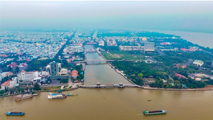
AsemconnectVietnam - General plan of Can Tho city is based on viewpoint of inheritance and development, in accordance with the Party's Resolutions on plan, construction, management and sustainable development of Vietnamese cities
General plan task of Can Tho City until 2050 with a vision to 2075
1. Scope, scale and timeframe of plan
a) Plan scope: Entire space within administrative boundaries of Can Tho City, including 103 commune-level administrative units (Resolution No. 1668/NQ-UBTVQH15 dated June 16, 2025, of Standing Committee of the National Assembly) and relevant marine space as stipulated by current law; plan scope is defined as follows:
- Northeast bordering Vinh Long and Dong Thap provinces.
- Northwest and Southwest bordering Ca Mau and An Giang provinces.
- Southeast bordering the East Sea.
b) Planning scope: Total natural area for plan is approximately 6,360.98 km2 (according to Resolution No.202/2025/QH15 dated June 12, 2025, of National Assembly on rearrangement of provincial-level administrative units) and plan scope on the sea is in accordance with current legal regulations.
(Boundaries, scope and scale of the plan will be specified during plan research process, based on documents, maps, plan options and more specific data)
c) Plan period until 2050, vision until 2075.
2. Plan viewpoints and objectives
a) Viewpoints
- General plan of Can Tho city is based on viewpoint of inheritance and development, in accordance with the Party's Resolutions on plan, construction, management and sustainable development of Vietnamese cities;
- To guide socio-economic development and ensure national defense and security in Mekong Delta region; to build and develop Can Tho city and resolution of the first Congress of Can Tho City Party Committee, term 2025-2030.
- To concretize and align with national-level plans, sectoral plans, Mekong Delta regional plan and adjusted Can Tho city plan for period of 2021-2030, with a vision to 2050.
- To demonstrate vision and strategy, ensuring flexibility and diversity in land use, serving as a basis for achieving long-term development goals; improving quality of life for people and socio-economic activities in Can Tho city.
- Ensuring harmonious development between economic growth and cultural and social development, environmental protection, adaptation to climate change, green growth, and promoting the application of science and technology and innovation.
b) Objectives
- To concretize development orientation of Can Tho City in national and Mekong Delta region's socio-economic development strategy; ensuring strong national defense and security.
- To develop Can Tho City into a growth pole, a core urban area, and a driving force for development of Mekong Delta region with an expanded development space towards the sea; a gateway for maritime import and export associated with special Tran De seaport; - Linking sub-regional center along economic corridors will facilitate attraction of resources to further develop Can Tho City into a regional center for science and technology and innovation, trade, tourism, logistics, processing and manufacturing industries, smart agriculture, high-tech applications, education and training, specialized healthcare, culture and sports.
- Developing Can Tho City in conjunction with its unique riverine cultural identity, potential and advantages as a regional economic center in urban development and socio-economic development of the Mekong Delta; having a synchronized infrastructure that effectively connects with economic corridors; ensuring regional, national and international linkages; and completing strategy for adapting to climate change in the lower Mekong River basin.
- To develop Can Tho city into a modern, distinctive riverine urban center connected to natural infrastructure (canals, rivers, and the sea) of Southeast Asia, a "Green, Smart, and Distinctive Mekong Gateway"; a center for energy, river-sea logistics and high-end urban services in region; a green and circular industry leading low-emission agricultural value chain; a knowledge-based, civilized society with a high quality of life for its citizens, a safe environment, modern infrastructure and smart and sustainable connectivity.
- To establish a spatial development structure, social infrastructure system, technical infrastructure, land use plan and environmental protection to maximize implementation of socio-economic development and national defense and security strategies as defined in National Plan, regional plan and city plan.
- Vision to 2075: Can Tho will be an ecological, civilized and modern city deeply rooted in the riverine identity of Mekong Delta region. Belonging to group of moderately developed cities in Asia; a city with comprehensive, sustainable development, adaptability and resilience to climate change and environmental protection, developing harmoniously with natural landscape, becoming a highly attractive destination on the world tourism map.
3. Characteristics
- Can Tho City is a Class I urban area, core urban area of Mekong Delta region, and a growth pole, promoting development for entire region and the nation.
- Mekong Delta regional center for science and technology and innovation, finance, services, tourism, processing and manufacturing industries, smart agriculture, high-tech applied agriculture; a center for trade, logistics and energy coordination; a center for education and training, specialized healthcare, science and technology, culture and sports.
- A key transportation and international trade hub, an important digital infrastructure for Mekong Delta region and nation, an important gateway to lower Mekong River basin, with Tran De special seaport serving as the region's maritime import and export gateway.
- One of key areas with a strategically important position for national defense and security in Mekong Delta region and the entire country.
4. Preliminary development forecast
a) Population size
Projected by 2050: Total population of the city will be approximately 6.1 million people; of which actual resident population is approximately 4.1 million people.
b) Regarding land area
Urban construction land is projected to be approximately 85,000ha - 112,000ha by 2050.
(Projected population and land area will be specifically proposed during plan research process, ensuring compliance with standards, current conditions and development goals of Can Tho City.)
5. Research requirements for plan content
a) Regarding analysis of location, role and regional relationships
- Review and clearly identify position and regional relationships of Can Tho City in context of the region, the country and national urban network, in relation to new situation (administrative unit rearrangement; adjustment of planning for infrastructure sectors, science and technology, digital transformation, and meeting socio-economic growth targets...).
- Analyze regional relationship of Can Tho city within the Mekong Delta region, Ho Chi Minh City region, national urban system, along Can Tho - My Tho - Ho Chi Minh City economic-urban corridor, Chau Doc - Tran De economic corridor and within region and internationally; clarify tasks regarding infrastructure development and determine urban spatial structure and land use plan for the city's expansion towards the sea, as a center and hub of marine economic region, connected to coastal corridor, port center, logistics, serving as gateway to the sea for the region and linking sub-regional centers along economic corridors. Research and identify the contents of Can Tho city as stipulated in the revised planning document for Mekong Delta region for a period of 2021-2030, with a vision to 2050 (Decision 616/QD-TTg of 2026 and Decision 287/QD-TTg of 2022 of the Prime Minister) to assess position, nature and role of new Can Tho city after the merger.
b) Regarding assessment of current situation:
- Synthesize and collect information, documents, data, surveys and create maps to serve plan process; analyze and evaluate natural conditions; and assess current state of economic development.
- Assess current state of urban and rural systems and functional areas; clarify urban network, relationship and role of urban areas in Can Tho city after rearrangement and merger; identify existing problems, inadequacies and issues requiring supplementation and development.
- Evaluate implementation of approved urban and rural planning laws regarding structure, spatial distribution and land scale in accordance with current role, position, nature and function of Can Tho City, as well as the requirements and orientations set forth by higher-level plans.
- Review and assess current population and distribution in urban and rural areas; current state of urban and rural land use throughout the city; current state of architectural landscape; current state of social infrastructure, housing, technical infrastructure and environment; and impact of climate change and sea level rise on development space of Can Tho City.
- Evaluate current status of important investment and development programs and projects being implemented in the city.
- Identify issues and contents that need to be addressed in general plan of Can Tho City until 2050, with a vision to 2075.
c) Regarding viewpoints, objectives, nature and prerequisites for development
Determine requirements and content must be consistent with national-level planning, sectoral plan, Mekong Delta regional plan and Can Tho City Plan (amended) for the city's development orientation; at the same time, based on research into international experience in development and management of cities with similar characteristics to Can Tho City.
d) Regarding forecast of population size, labor force and land area.
Forecasting population size, labor force and land area based on the characteristics of Can Tho City as a river-water urban area connected to natural infrastructure (canals, rivers, sea); as a core urban area, center, and growth pole promoting development of Mekong Delta region in many sectors and fields. Simultaneously, identification and selection of indicators for technical infrastructure, social infrastructure and environmental protection must ensure scientific and practicality, efficient and economical land use and suitability with available resources, implemented in stages and in compliance with national technical standards for urban and rural plan.
e) Regarding model and development orientation of urban spatial structure:
- Identifying and selecting a spatial development plan for urban and rural areas based on principles and criteria suitable to natural conditions and topography of Can Tho City; From there, determine overall spatial model and structure of entire city with the identity of a river-water city associated with natural infrastructure (canals, rivers, sea), consistent with development model and spatial structure of Mekong Delta region, connecting key cities in Mekong Delta region and Ho Chi Minh City area.
- Determine boundaries and spatial development orientation for urban and rural areas in accordance with urban development plan in Can Tho City Planning and long-term orientation, aiming to protect and enhance value and unique identity of Can Tho city, creating conditions to attract investment in urban renovation, upgrading, reconstruction and development.
- Orient spatial organization including functional zones; key development areas; areas of national importance in terms of politics, culture, history, security and defense; - System of administrative, training, medical, cultural, sports and other specialized centers at the national, regional and city levels.
- Orientation of architectural landscape zoning; green spaces and water bodies, gateway areas, main spatial axes, city landmarks; preservation of natural landscapes and cultural heritage.
- Specifying characteristic values of ecosystem, historical values, cultural identity of river and architectural regions of Mekong Delta in spatial organization orientation, technical infrastructure planning and land use plan, while ensuring adaptability to climate change and sea level rise, increasing resilience and disaster prevention.
f) Regarding land use plan
- Orientation of land use plan for entire city according to planning stages, identifying urban and rural development areas, functional areas; agricultural production areas, forestry areas, national defense, security areas and other areas according to development objectives.
- Determine land use needs for housing development, including need for social housing.
- Ensure allocation of development space for industries, sectors and activities that create new growth drivers (science and technology, digital transformation, high-tech agricultural production, education and training, healthcare, seaports, logistics, etc.); ensure efficient agricultural production space and reserve land for future development.
- Orient development of new urban land and restructure land use rationally, ensuring flexibility and meeting development needs in line with defined planning goals and vision.
g) Regarding external transportation
- Determine external transportation network according to national-level planning, regional plan and Can Tho City plan, including roads, railways, maritime routes, inland waterways and air routes; Long-term air transport needs will serve as basis for researching options for developing a new airport in line with the national airport system plan, aiming to enhance regional and international connectivity, support socio-economic development and logistics system; and to research exploitation and effective utilization of potential of inland waterway transport, improve cargo and passenger transport capacity, linked to the development of the logistics system, contributing to strengthening Can Tho's role as a trade hub in the region and internationally.
h) Regarding orientation of technical infrastructure and underground space development
Orientation of technical infrastructure and underground space development is consistent with conditions of Can Tho city, which is located in an area heavily impacted by climate change (drought, saltwater intrusion, sea level rise, subsidence, etc.). Specifically as follows:
- Identifying needs for use and development of transportation, main urban transportation network (including transportation modes suitable to the characteristics of a river-based city); determining location and scale of major transportation hubs suitable for each plan stage; proposing application of science and technology, smart technology and support tools in management and development of transportation infrastructure. Proposing development of modern public transportation methods (boats, express/regular buses, urban rail, etc.) to effectively connect functional areas of the city; researching system of bridges and tunnels connecting the city across river systems in central urban areas;
- Static traffic plan ensures that it meets usage needs and takes into account space requirements for green transportation.
- Determine needs, drainage basins and main drainage directions suitable for each planning phase; propose solutions for flood prevention and control, flood management, location and scale of drainage works; propose orientations, principles and groups of solutions for managing ground elevation and surface water drainage throughout the city, with a focus on considering impacts of land subsidence and climate change. When proposing solutions and projects for managing irrigation system, it is necessary to ensure that factors promoting waterway transport – a unique mode of transport in Can Tho city and the Mekong Delta region – are taken into account.
- Determine needs and sources of water supply for urban areas, rural areas, industrial zones and other functional areas suitable for each planning phase; regional water supply relationships;
- Determine projected location, scale and capacity of key water supply facilities and distribution networks.
- Identify energy needs, supply sources, locations and scale of key facilities and main transmission and distribution lines for urban energy and lighting system, in accordance with each planning phase. Study rational arrangement of infrastructure for storing and supplying petroleum, natural gas and other energy sources.
- Determine wastewater drainage needs and systems for each area in the city, proposing an optimal collection network to improve collection and treatment rate of wastewater in accordance with each plan phase; project location, capacity and scale of key facilities (wastewater treatment plants, pumping stations).
- Determine needs and systems for collecting and treating solid waste and managing cemeteries and crematoriums;
- Determine planned location, scale and capacity of solid waste treatment area, cemetery and crematorium, ensuring compliance with environmental protection requirements.
- Identify needs and development orientation of information and communication infrastructure and digital infrastructure suitable for each planning phase; propose regulations on the management and arrangement of undergrounding and shared use of telecommunications network infrastructure.
- Determine needs and development orientation of underground space suitable for each planning phase, ensuring multi-functional exploitation and efficient use of urban space.
i) Regarding environmental protection solutions:
- Establish ecological and environmental protection zones; restore environment affected by investment and construction activities; requirements for waste management and pollution control during investment and construction process according to the plan.
k) Regarding priority programs and projects:
- Justify and identify priority investment programs and projects according to the planning phases, ensuring feasibility in implementation.
- Identify requirements in general implementation plan.
6. Requirements for plan documents and products
List of documents and plan content shall comply with regulations in Article 10, Circular No.16/2025/TT-BXD dated June 30, 2025, of Minister of Construction detailing some provisions of Law on urban and rural plan
7. Requirements and principles for obtaining opinions
Process of obtaining opinions during preparation of general plan of Can Tho City until 2050, with a vision to 2075, shall be carried out in accordance with provisions of Article 37 of Law on urban and rural plan and other relevant legal documents.
8. Implementation organization
a) Implementation organization
- Approval authority: The Prime Minister.
- Appraisal agency: Ministry of Construction.
- Agency responsible for preparing and submitting the plan for approval: People's Committee of Can Tho City.
- Method of selecting the plan consultancy organization: According to current legal regulations.
- Plan plan and schedule: Submit the plan for approval in December 2026.
b) Funding and implementation costs
- Funding sources: State budget funds and other legal sources as prescribed by law.
- Costs for organizing preparation, appraisal, approval and publication of the plan: Implemented according to current regulations; Cost estimates will be prepared after the planning task is approved.
c) People's Committee of Can Tho City is fully responsible for documentation, procedures and accuracy of information, data, drawings, and documents used in preparation of general planning task for Can Tho City until 2050, with a vision to 2075, ensuring compliance with legal regulations; and for storing and archiving the approved documents of general plan task for Can Tho City until 2050, with a vision to 2075, in accordance with regulations.
d) People's Committee of Can Tho City shall allocate funds and approve cost estimates for the planning work; coordinate with Ministry of Construction and other relevant ministries and agencies to organize preparation and submission for approval of general plan for Can Tho City until 2050, with a vision to 2075, in accordance with legal regulations, avoiding overlaps, disputes and lawsuits; and preventing loss or waste of state assets.
e) Ministry of Construction is responsible for ensuring content of appraisal report complies with legal regulations; storing and archiving approved general plan task of Can Tho City until 2050 with a vision to 2075; and guiding People's Committee of Can Tho City in process of organizing implementation of general plan for Can Tho City until 2050, with a vision to 2075, ensuring compliance with legal regulations.
Source: Vitic/ thuvienphapluat.vn
1. Scope, scale and timeframe of plan
a) Plan scope: Entire space within administrative boundaries of Can Tho City, including 103 commune-level administrative units (Resolution No. 1668/NQ-UBTVQH15 dated June 16, 2025, of Standing Committee of the National Assembly) and relevant marine space as stipulated by current law; plan scope is defined as follows:
- Northeast bordering Vinh Long and Dong Thap provinces.
- Northwest and Southwest bordering Ca Mau and An Giang provinces.
- Southeast bordering the East Sea.
b) Planning scope: Total natural area for plan is approximately 6,360.98 km2 (according to Resolution No.202/2025/QH15 dated June 12, 2025, of National Assembly on rearrangement of provincial-level administrative units) and plan scope on the sea is in accordance with current legal regulations.
(Boundaries, scope and scale of the plan will be specified during plan research process, based on documents, maps, plan options and more specific data)
c) Plan period until 2050, vision until 2075.
2. Plan viewpoints and objectives
a) Viewpoints
- General plan of Can Tho city is based on viewpoint of inheritance and development, in accordance with the Party's Resolutions on plan, construction, management and sustainable development of Vietnamese cities;
- To guide socio-economic development and ensure national defense and security in Mekong Delta region; to build and develop Can Tho city and resolution of the first Congress of Can Tho City Party Committee, term 2025-2030.
- To concretize and align with national-level plans, sectoral plans, Mekong Delta regional plan and adjusted Can Tho city plan for period of 2021-2030, with a vision to 2050.
- To demonstrate vision and strategy, ensuring flexibility and diversity in land use, serving as a basis for achieving long-term development goals; improving quality of life for people and socio-economic activities in Can Tho city.
- Ensuring harmonious development between economic growth and cultural and social development, environmental protection, adaptation to climate change, green growth, and promoting the application of science and technology and innovation.
b) Objectives
- To concretize development orientation of Can Tho City in national and Mekong Delta region's socio-economic development strategy; ensuring strong national defense and security.
- To develop Can Tho City into a growth pole, a core urban area, and a driving force for development of Mekong Delta region with an expanded development space towards the sea; a gateway for maritime import and export associated with special Tran De seaport; - Linking sub-regional center along economic corridors will facilitate attraction of resources to further develop Can Tho City into a regional center for science and technology and innovation, trade, tourism, logistics, processing and manufacturing industries, smart agriculture, high-tech applications, education and training, specialized healthcare, culture and sports.
- Developing Can Tho City in conjunction with its unique riverine cultural identity, potential and advantages as a regional economic center in urban development and socio-economic development of the Mekong Delta; having a synchronized infrastructure that effectively connects with economic corridors; ensuring regional, national and international linkages; and completing strategy for adapting to climate change in the lower Mekong River basin.
- To develop Can Tho city into a modern, distinctive riverine urban center connected to natural infrastructure (canals, rivers, and the sea) of Southeast Asia, a "Green, Smart, and Distinctive Mekong Gateway"; a center for energy, river-sea logistics and high-end urban services in region; a green and circular industry leading low-emission agricultural value chain; a knowledge-based, civilized society with a high quality of life for its citizens, a safe environment, modern infrastructure and smart and sustainable connectivity.
- To establish a spatial development structure, social infrastructure system, technical infrastructure, land use plan and environmental protection to maximize implementation of socio-economic development and national defense and security strategies as defined in National Plan, regional plan and city plan.
- Vision to 2075: Can Tho will be an ecological, civilized and modern city deeply rooted in the riverine identity of Mekong Delta region. Belonging to group of moderately developed cities in Asia; a city with comprehensive, sustainable development, adaptability and resilience to climate change and environmental protection, developing harmoniously with natural landscape, becoming a highly attractive destination on the world tourism map.
3. Characteristics
- Can Tho City is a Class I urban area, core urban area of Mekong Delta region, and a growth pole, promoting development for entire region and the nation.
- Mekong Delta regional center for science and technology and innovation, finance, services, tourism, processing and manufacturing industries, smart agriculture, high-tech applied agriculture; a center for trade, logistics and energy coordination; a center for education and training, specialized healthcare, science and technology, culture and sports.
- A key transportation and international trade hub, an important digital infrastructure for Mekong Delta region and nation, an important gateway to lower Mekong River basin, with Tran De special seaport serving as the region's maritime import and export gateway.
- One of key areas with a strategically important position for national defense and security in Mekong Delta region and the entire country.
4. Preliminary development forecast
a) Population size
Projected by 2050: Total population of the city will be approximately 6.1 million people; of which actual resident population is approximately 4.1 million people.
b) Regarding land area
Urban construction land is projected to be approximately 85,000ha - 112,000ha by 2050.
(Projected population and land area will be specifically proposed during plan research process, ensuring compliance with standards, current conditions and development goals of Can Tho City.)
5. Research requirements for plan content
a) Regarding analysis of location, role and regional relationships
- Review and clearly identify position and regional relationships of Can Tho City in context of the region, the country and national urban network, in relation to new situation (administrative unit rearrangement; adjustment of planning for infrastructure sectors, science and technology, digital transformation, and meeting socio-economic growth targets...).
- Analyze regional relationship of Can Tho city within the Mekong Delta region, Ho Chi Minh City region, national urban system, along Can Tho - My Tho - Ho Chi Minh City economic-urban corridor, Chau Doc - Tran De economic corridor and within region and internationally; clarify tasks regarding infrastructure development and determine urban spatial structure and land use plan for the city's expansion towards the sea, as a center and hub of marine economic region, connected to coastal corridor, port center, logistics, serving as gateway to the sea for the region and linking sub-regional centers along economic corridors. Research and identify the contents of Can Tho city as stipulated in the revised planning document for Mekong Delta region for a period of 2021-2030, with a vision to 2050 (Decision 616/QD-TTg of 2026 and Decision 287/QD-TTg of 2022 of the Prime Minister) to assess position, nature and role of new Can Tho city after the merger.
b) Regarding assessment of current situation:
- Synthesize and collect information, documents, data, surveys and create maps to serve plan process; analyze and evaluate natural conditions; and assess current state of economic development.
- Assess current state of urban and rural systems and functional areas; clarify urban network, relationship and role of urban areas in Can Tho city after rearrangement and merger; identify existing problems, inadequacies and issues requiring supplementation and development.
- Evaluate implementation of approved urban and rural planning laws regarding structure, spatial distribution and land scale in accordance with current role, position, nature and function of Can Tho City, as well as the requirements and orientations set forth by higher-level plans.
- Review and assess current population and distribution in urban and rural areas; current state of urban and rural land use throughout the city; current state of architectural landscape; current state of social infrastructure, housing, technical infrastructure and environment; and impact of climate change and sea level rise on development space of Can Tho City.
- Evaluate current status of important investment and development programs and projects being implemented in the city.
- Identify issues and contents that need to be addressed in general plan of Can Tho City until 2050, with a vision to 2075.
c) Regarding viewpoints, objectives, nature and prerequisites for development
Determine requirements and content must be consistent with national-level planning, sectoral plan, Mekong Delta regional plan and Can Tho City Plan (amended) for the city's development orientation; at the same time, based on research into international experience in development and management of cities with similar characteristics to Can Tho City.
d) Regarding forecast of population size, labor force and land area.
Forecasting population size, labor force and land area based on the characteristics of Can Tho City as a river-water urban area connected to natural infrastructure (canals, rivers, sea); as a core urban area, center, and growth pole promoting development of Mekong Delta region in many sectors and fields. Simultaneously, identification and selection of indicators for technical infrastructure, social infrastructure and environmental protection must ensure scientific and practicality, efficient and economical land use and suitability with available resources, implemented in stages and in compliance with national technical standards for urban and rural plan.
e) Regarding model and development orientation of urban spatial structure:
- Identifying and selecting a spatial development plan for urban and rural areas based on principles and criteria suitable to natural conditions and topography of Can Tho City; From there, determine overall spatial model and structure of entire city with the identity of a river-water city associated with natural infrastructure (canals, rivers, sea), consistent with development model and spatial structure of Mekong Delta region, connecting key cities in Mekong Delta region and Ho Chi Minh City area.
- Determine boundaries and spatial development orientation for urban and rural areas in accordance with urban development plan in Can Tho City Planning and long-term orientation, aiming to protect and enhance value and unique identity of Can Tho city, creating conditions to attract investment in urban renovation, upgrading, reconstruction and development.
- Orient spatial organization including functional zones; key development areas; areas of national importance in terms of politics, culture, history, security and defense; - System of administrative, training, medical, cultural, sports and other specialized centers at the national, regional and city levels.
- Orientation of architectural landscape zoning; green spaces and water bodies, gateway areas, main spatial axes, city landmarks; preservation of natural landscapes and cultural heritage.
- Specifying characteristic values of ecosystem, historical values, cultural identity of river and architectural regions of Mekong Delta in spatial organization orientation, technical infrastructure planning and land use plan, while ensuring adaptability to climate change and sea level rise, increasing resilience and disaster prevention.
f) Regarding land use plan
- Orientation of land use plan for entire city according to planning stages, identifying urban and rural development areas, functional areas; agricultural production areas, forestry areas, national defense, security areas and other areas according to development objectives.
- Determine land use needs for housing development, including need for social housing.
- Ensure allocation of development space for industries, sectors and activities that create new growth drivers (science and technology, digital transformation, high-tech agricultural production, education and training, healthcare, seaports, logistics, etc.); ensure efficient agricultural production space and reserve land for future development.
- Orient development of new urban land and restructure land use rationally, ensuring flexibility and meeting development needs in line with defined planning goals and vision.
g) Regarding external transportation
- Determine external transportation network according to national-level planning, regional plan and Can Tho City plan, including roads, railways, maritime routes, inland waterways and air routes; Long-term air transport needs will serve as basis for researching options for developing a new airport in line with the national airport system plan, aiming to enhance regional and international connectivity, support socio-economic development and logistics system; and to research exploitation and effective utilization of potential of inland waterway transport, improve cargo and passenger transport capacity, linked to the development of the logistics system, contributing to strengthening Can Tho's role as a trade hub in the region and internationally.
h) Regarding orientation of technical infrastructure and underground space development
Orientation of technical infrastructure and underground space development is consistent with conditions of Can Tho city, which is located in an area heavily impacted by climate change (drought, saltwater intrusion, sea level rise, subsidence, etc.). Specifically as follows:
- Identifying needs for use and development of transportation, main urban transportation network (including transportation modes suitable to the characteristics of a river-based city); determining location and scale of major transportation hubs suitable for each plan stage; proposing application of science and technology, smart technology and support tools in management and development of transportation infrastructure. Proposing development of modern public transportation methods (boats, express/regular buses, urban rail, etc.) to effectively connect functional areas of the city; researching system of bridges and tunnels connecting the city across river systems in central urban areas;
- Static traffic plan ensures that it meets usage needs and takes into account space requirements for green transportation.
- Determine needs, drainage basins and main drainage directions suitable for each planning phase; propose solutions for flood prevention and control, flood management, location and scale of drainage works; propose orientations, principles and groups of solutions for managing ground elevation and surface water drainage throughout the city, with a focus on considering impacts of land subsidence and climate change. When proposing solutions and projects for managing irrigation system, it is necessary to ensure that factors promoting waterway transport – a unique mode of transport in Can Tho city and the Mekong Delta region – are taken into account.
- Determine needs and sources of water supply for urban areas, rural areas, industrial zones and other functional areas suitable for each planning phase; regional water supply relationships;
- Determine projected location, scale and capacity of key water supply facilities and distribution networks.
- Identify energy needs, supply sources, locations and scale of key facilities and main transmission and distribution lines for urban energy and lighting system, in accordance with each planning phase. Study rational arrangement of infrastructure for storing and supplying petroleum, natural gas and other energy sources.
- Determine wastewater drainage needs and systems for each area in the city, proposing an optimal collection network to improve collection and treatment rate of wastewater in accordance with each plan phase; project location, capacity and scale of key facilities (wastewater treatment plants, pumping stations).
- Determine needs and systems for collecting and treating solid waste and managing cemeteries and crematoriums;
- Determine planned location, scale and capacity of solid waste treatment area, cemetery and crematorium, ensuring compliance with environmental protection requirements.
- Identify needs and development orientation of information and communication infrastructure and digital infrastructure suitable for each planning phase; propose regulations on the management and arrangement of undergrounding and shared use of telecommunications network infrastructure.
- Determine needs and development orientation of underground space suitable for each planning phase, ensuring multi-functional exploitation and efficient use of urban space.
i) Regarding environmental protection solutions:
- Establish ecological and environmental protection zones; restore environment affected by investment and construction activities; requirements for waste management and pollution control during investment and construction process according to the plan.
k) Regarding priority programs and projects:
- Justify and identify priority investment programs and projects according to the planning phases, ensuring feasibility in implementation.
- Identify requirements in general implementation plan.
6. Requirements for plan documents and products
List of documents and plan content shall comply with regulations in Article 10, Circular No.16/2025/TT-BXD dated June 30, 2025, of Minister of Construction detailing some provisions of Law on urban and rural plan
7. Requirements and principles for obtaining opinions
Process of obtaining opinions during preparation of general plan of Can Tho City until 2050, with a vision to 2075, shall be carried out in accordance with provisions of Article 37 of Law on urban and rural plan and other relevant legal documents.
8. Implementation organization
a) Implementation organization
- Approval authority: The Prime Minister.
- Appraisal agency: Ministry of Construction.
- Agency responsible for preparing and submitting the plan for approval: People's Committee of Can Tho City.
- Method of selecting the plan consultancy organization: According to current legal regulations.
- Plan plan and schedule: Submit the plan for approval in December 2026.
b) Funding and implementation costs
- Funding sources: State budget funds and other legal sources as prescribed by law.
- Costs for organizing preparation, appraisal, approval and publication of the plan: Implemented according to current regulations; Cost estimates will be prepared after the planning task is approved.
c) People's Committee of Can Tho City is fully responsible for documentation, procedures and accuracy of information, data, drawings, and documents used in preparation of general planning task for Can Tho City until 2050, with a vision to 2075, ensuring compliance with legal regulations; and for storing and archiving the approved documents of general plan task for Can Tho City until 2050, with a vision to 2075, in accordance with regulations.
d) People's Committee of Can Tho City shall allocate funds and approve cost estimates for the planning work; coordinate with Ministry of Construction and other relevant ministries and agencies to organize preparation and submission for approval of general plan for Can Tho City until 2050, with a vision to 2075, in accordance with legal regulations, avoiding overlaps, disputes and lawsuits; and preventing loss or waste of state assets.
e) Ministry of Construction is responsible for ensuring content of appraisal report complies with legal regulations; storing and archiving approved general plan task of Can Tho City until 2050 with a vision to 2075; and guiding People's Committee of Can Tho City in process of organizing implementation of general plan for Can Tho City until 2050, with a vision to 2075, ensuring compliance with legal regulations.
Source: Vitic/ thuvienphapluat.vn

Public debt borrowing and repayment plan for 2026
Ensuring resources: Mobilizing sufficient and timely borrowed capital at reasonable costs and acceptable risks to meet expenditure needs ...Plan on implementation of high-tech law
Inter-sectoral legal support program for small and ...
Tourism destinations refresh offerings to welcome New ...
Across the Mekong Delta, many tourist sites have been busy upgrading their offerings. At the Con Son tourism site in Can Tho city, members ...Annual New Year festival shines in Da Nang
Phu Quoc emerging as a favourite global destination
Vietnam Airlines adds 270 flights to during 2026 New Year ...
