

Adjusted master plan on construction of Nhon Hoi economic zone, Binh Dinh province, until 2040
Monday, December 16,2019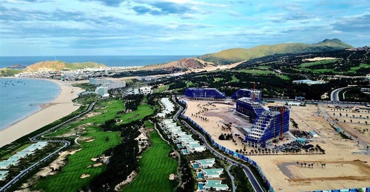
AsemconnectVietnam - Being a multi-sector and multi-sector economic zone with a focus on tourism, services, urban, industrial, seaports, renewable energy and fisheries
Adjusted master plan on construction of Nhon Hoi economic zone, Binh Dinh province, until 2040
1. Scope of plan:
The area is about 14,308 ha, including:
- Existing part: on Phuong Mai peninsula with an area of about 12,000 ha, in the administrative boundaries of Hai Cang ward and Nhon Hoi, Nhon Ly and Nhon Hai communes of Quy Nhon city; Cat Tien, Cat Hai and Cat Chanh communes of Phu Cat district; Phuoc Hoa and Phuoc Son communes of Tuy Phuoc district, Binh Dinh province; geographical limit to the north of Nui Ba, Cat Hai and Phu Cat districts; east and south borders to the East Sea; to the west by Thi Nai lagoon;
- Extension: in administrative boundaries of Canh Vinh commune, Van Canh district, Binh Dinh province with an area of about 2,308 ha; geographical limits to the north, west and south, bordering on hilly land of Van Canh district; the east borders on the existing residential area of Canh Vinh commune;
2. Functional properties:
- Being a multi-sector and multi-sector economic zone with a focus on tourism, services, urban, industrial, seaports, renewable energy and fisheries;
- Being a counterbalancing growth, closely and comprehensive link with general development of Quy Nhon city and its vicinity;
- Being one of main development centers of the central key economic region, an important international exchange and exchange hub of central Vietnam and the central highlands;
- It is an importance area of national security and defense.
3. Forecast of population and land use demand:
- By 2030, the total population is about 120,000 - 140,000 people; the demand for using construction land fund is about 8,461 ha;
- By 2040, the total population is about 200,000 - 250,000 people; demand for using construction land fund is about 10,746 ha.
4. Space development orientation:
a) Development model, orientation:
Spatial organization of economic zone on the basis of coordinating the following four basic spaces:
- Landscape space - ecological reserve: To protect landscape space of Van Canh, Phuong Mai and Nui Ba mountain ranges; protect landscape and biodiversity values of Thi Nai lagoon and neighboring ecosystems, in which the Con Chim area is preserved. development of renewable energy facilities at potential locations on Phuong Mai peninsula, on the principle of maximum protection of existing natural resources; to protect and rationally exploit coastal space strips according to law provisions on marine and island natural resources;
- Industrial development space: The industrial development orientation in Phuong Mai peninsula is clean industry, with high technology content, research and development, creative start-up. Becamex – Binh Dinh industrial park is an agricultural, forestry and fishery processing park; industrial production of construction materials, electronics manufacturing industry and electrical construction materials; textile, garment, leather and garment industries;
- Tourism development space: developing tourism areas along the East coast, ecotourism service points along Thi Nai lagoon and Mai Huong bay; develop tourism products according to the strength of each location in Tan Thanh - Vinh Hoi, Eo Gio, Ky Co, Phuong Mai, Nui Ba, Nhon Hai, Hon Kho, Hai Minh...
- Urban - rural development space: Forming and developing five new urban areas including: Cat Tien urban area, Nhon Hoi urban area, Mai Huong urban area, Becamex A urban area, Becamex B urban area. Improving and arranging local population for three existing rural residential clusters: residential area of Cat Hai commune, residential area of Nhon Hai commune, residential area in the submerged area of Thi Nai lagoon.
b) Functional subdivision:
The economic zone is divided into eight functional subdivisions, of which subdivisions 01-06 are located in the existing Part and subdivisions 07, 08 is located in the extension with the following major development directions:
- Subdivision 01 - Tan Thanh and Vinh Hoi urban and tourism areas: Being a high class urban and sea resort, developing ecological residential areas, tourism - services area with low density which associates with the protection of natural values, there are two mountain-oriented valleys with beautiful beaches; estimated population of about 23,000 people; natural land area is about 1,164 ha; the area of land for construction of functional areas is about 969 ha; population density of 50 - 70 people/ ha;
- Subdivision 02 - Cat Tien gateway urban area: is the northern gateway urban area, urban development, tourism - service with medium density; exploit potential of renewable energy development; preserving natural belts to prevent storms; estimated population of about 49,100 people; natural land area is about 1,606 ha; the area of construction of functional areas is about 1,305 ha; population density is from 60 to 80 people/ ha;
- Subdivision 03 - Nhon Hoi urban and tourist area: is an urban area with sea resort and entertainment center; grow with medium density; providing vocational training institutions, hospitals serving the whole peninsula; exploit the potential of renewable energy development; at the same time, preserving natural belts to prevent storms from the sea; preserve and exploit the value of endemic landscapes such as Eo Gio, Ky Co, Phuong Mai - Nui Ba national tourism route; estimated population of 78,300 people; natural land area is about 2,199 ha; the area of construction land for functional areas is about 2,005 ha, the population density is from 60 to 80 people/ ha;
- Subdivision 04 - Nhon Hoi urban industrial park: Developing Nhon Hoi industrial park, Nhon Hoi seaport area; Mai Huong urban area becomes an urban center - a trade - service complex serving the whole peninsula; conserving Mai Huong bay; developing service, entertainment and entertainment spaces, the Gulf coast tourism wharf; developing renewable energy associating with preserving ecological landscape on Phuong Mai mountain range; estimated population of about 29,100 people; natural land area is about 3,521 ha; land area for construction of functional areas is about 2,772 ha; population density from 40 - 60 people/ha;
- Subdivision 05 - Phuong Mai tourism urban area: Being a high-class urban and sea resort; developing ecological residential areas, tourism areas with low density, exploiting potential of developing renewable energy and protecting the existing natural values of the southern Phuong Mai peninsula; estimated population of about 13,000 people; natural land area is about 1,512 ha; land area for building functional areas is about 1,335 hectares; population density from 20-40 people/ ha;
- Subdivision 06 - Thi Nai lagoon: As a conservation area, preserving the unique ecological system of Thi Nai lagoon, developing conservation solutions such as reviving the mangrove forest, strictly controlling the population and activities of the pollution sources; developing sustainable tourism models; step by step transforming aquaculture on Thi Nai lagoon to sustainable environmental livelihood models; estimated population of about 1,800 people; natural land area is about 1,998 ha; the area of construction of functional areas is about 306 ha; population density is about 20-40 people/ ha;
- Subdivision 07 - Becamex A industrial and urban area is an industrial, urban and service complex, exploiting the strength of the position of the western gateway of Quy Nhon city and surrounding and welcoming north south highway; developing at medium density, protecting the natural value of the Ha Thanh river valley; estimated population of about 23,400 people; natural land area is about 1,425 ha; area of land for construction of functional areas is about 1,390 ha; population density is from 60 to 80 people/ ha;
- Subdivision 08 - Becamex B urban - service area: is a commercial service urban area, formed in the long-term period, with an estimated population of 32,300 people; natural land area is about 883 ha; the area for construction of functional areas is about 662 ha; population density ranges from 50 to 70 people/ ha.
c) Socio-economic infrastructure system:
- The system of administrative works: Newly building the administrative center of the economic zone, about 11 hectares;
- The system of education and training works: To build a new vocational training center, about 19 hectares in size; build new high school system in urban areas; upgrade, expand and adjust the grassroots education network;
- System of medical and healthcare facilities: building a new general hospital with a scale of about 10 hectares; newly build medical examination and treatment facilities in urban areas; encourage development and management of a standard private health system;
- System of cultural works: building a new center for performing arts and cultural centers with a scale of about 5 hectares; building a new network of cultural houses, clubs and libraries in urban areas;
- System of physical training and sport works: To build a new physical training and sport center, with a scale of about 8 hectares; newly build urban-level sports training projects in urban areas;
- System of urban parks: encouraging development of specialized parks for tourism; build entertainment parks in urban areas, arrange enough land and convenient locations to develop urban green trees and flower gardens; linking to share flexible functions between greenery systems and greenery areas and water reserves;
- Trading and service system: Creating conditions for the development of traffic distribution service at Nhon Hoi port to be a logistics center of the Central region; focus on developing mixed centers in new urban areas, especially in Mai Huong urban area; developing a network of commercial centers linked to the public transport network.
5. Land use orientation:
The total natural area of the economic zone is 14,308 ha.
a) By 2030:
- Land for construction of urban areas and rural residential areas: about 2,529 hectares, accounting for 17.7%;
- Land for construction of industrial parks: 1,175 ha, accounting for 8.2%;
- Land for renewable energy development: about 755 ha, accounting for 5.3%;
- Land for tourism, service and mixed areas: about 1,387 hectares, accounting for 9.7%;
- Land for specialized parks: about 698 ha, accounting for 4.9%;
- Ecological and isolated greenery land: about 1,066 ha, accounting for 7.5%;
- Land and port area: about 92 hectares, accounting for 0.6%;
- Land for infrastructure and technical works: about 49 ha, accounting for 0.3%;
- Land for external and inter-regional transportation: about 262 hectares, accounting for 1.8%;
- Non-construction land including water surface for aquaculture, beaches, cemeteries, agriculture and unused hills and mountains: about 6,295 ha, accounting for 44.0%.
- Non-construction land including water surface for aquaculture, beaches, cemeteries, agriculture and unused hills and mountains: about 6,295 ha, accounting for 44.0%.
b) By 2040:
- Land for construction of urban areas and rural residential areas: 3,361 ha, accounting for 23.5%;
- Land for construction of industrial parks: 1,743 ha, accounting for 12.2%;
- Land for renewable energy development: about 995 ha, accounting for 7.0%.
- Land for tourism, service and mixed areas: about 1,470 ha, accounting for 10.3%;
- Land for specialized parks: about 728 ha, accounting for 5.1%;
- Ecological and isolated green tree land: about 1,930 ha, accounting for 13.5%;
- Land and port area: about 92 hectares, accounting for 0.6%;
- Land for infrastructure and technical works: about 49 ha, accounting for 0.3%;
- Land for external and inter-regional transportation: about 378 ha, accounting for 2.6%;
- Non-construction land including water surface for aquaculture, beaches, cemeteries, agriculture and unused hills and mountains: about 3,562 ha, accounting for 24.9%.
6. Orientation of architecture and landscape:
a) System of operation centers and gateway areas:
- System of operation centers consists of three levels: mixed urban center is the core of activities of Cat Tien urban area, Nhon Hoi urban area, Mai Huong urban area, Becamex A and B urban areas; The complex of service centers is a complex of buildings providing services to Tan Thanh, Vinh Hoi, Trung Hoi, Nhon Ly, Ky Co, Eo Vot, Nhon Hai, Hon Kho, Hai Minh and Mai Huong bay. Mixed service center points: are multi-purpose buildings or key public spaces such as the Northern marina, the center of the marina, the southern marina ... provide ecotourism services along Thi Nai lagoon;
- Gateway areas include four operating centers: to the south is the Mai Huong commercial and service center; in the north is Cat Tien urban center; to the west is Becamex A urban center; in the to the east is Nhon Hoi port - Mai Huong bay;
- Centers of operation vary in size but are similar in principle to the organization of space, such as creating a lively service neighborhood, attracting businesses in trade and services, as a system focal public transport point, able to meet many different types of buildings, flexible urban structure according to changing market needs; diverse combinations, functional mixes.
b) Main space axes:
- Main landscape axes include: Core axis of Phuong Mai peninsula (national road No.19B) through the cities of Cat Tien, Nhon Hoi and Mai Huong; the coastal axis passes from Tan Thanh pass to Eo Gio; axis along Thi Nai lagoon through the urban areas of Cat Tien, Nhon Hoi and Mai Huong; axis approaching Phuong Mai peninsula including Thi Nai 1 bridge, Thi Nai 2 bridge and Bac Thi Nai bridge; axis of Ha Thanh river landscape;
- Principles for organizing the main axis space are as follows:
+ View from public places to the landscapes identified and built up rules of preservation and must be restored if compromised by construction of structures or unsuitable masses; consists of 5 following visions: from the beginning of Thi Nai bridge to the top of Phuong Mai mountain; from intersection of Cat Tien urban center to Nhon Hoi sea square; from Mai Huong urban center intersection to Mai Huong bay square; from Quy Nhon port tip to Nhon Hoi port; from the tip of Quy Nhon bay to Tran Hung Dao monument;
+ Arrange streets or walkways, ensuring public access to all open spaces such as sand dunes, beaches;
+ Landscape of the routes, themed culture, trade, coast, ecological lagoon ... should be implemented specifically to set orientation to ensure suitability of nature of the route and current rules.
c) Management of construction height and density:
- Manage according to construction control indicators (maximum land use coefficient) associated with land use types; according to the urban design guidelines and current regulations;
- Manage coastal space in accordance with regulations on natural resources, marine and island environment;
- Space management at Dam Thi Nai ensures a non-construction buffer along the water surface with a minimum width of 30 m;
- To control the height and density of construction of coastal, lagoon, bay, river and lake constructions, on principle of not creating too great impressions on building volumes in the visual sense of people walking around waterface; keep a reasonable distance between building blocks to optimize visibility and microclimate for the following class works.
7. Orientation of technical infrastructure systems:
a) Orientation of transport system:
- Outbound traffic:
+ Roads: To build a new belt route linking with the North-South expressway with 4-6 lanes and up to grade-II and III delta road standards. To complete trunk road of the extended economic zone connecting with national highway 1 and Phu Cat airport, with a scale of 6-8 lanes and a management road of 60m wide. Upgrading national highway No.19C section through Became urban industrial park will reach the standards of grade III, IV, 2 lanes and the minimum road level of DT 639 to reach level III delta. The section passing through the proposed urban development area is built according to urban road standards. New construction of Thi Nai bridge 2 parallel to the north of Thi Nai 1 bridge, new construction of Bac Thi Nai bridge connecting DT 640 road with the main road of Phuong Mai peninsula; To build a new bridge across Ha Thanh river, linking Becamex industrial park with Becamex new urban center (Canh Vinh).
+ Waterway traffic: Nhon Hoi wharf area of Quy Nhon seaport has a specialized function, directly serving industrial and service establishments, having ability to receive ships of up to 10,000 - 50,000 DWT, construction investment to build a port area according to the detailed plan prescribed by the Ministry of Transport; newly constructing Mai Huong tourism wharf has the capacity to receive international passenger ships, carrying up to 4,000 passengers. Newly build Bac Thi Nai marina at Cat Tien, anchorage area for fishing boats, area of Nhon Hoi and Tan Thanh - Vinh Hoi ports at Ba mountain tip reaching the sea, at Eo Gio - Nhon Ly at the beginning of Cam mountain, Nhon Hai wharf is upgraded from the anchorage point of boats in Nhon Hai village...
- Internal transportation:
+ To build a new trunk road to the west of Phuong Mai peninsula with a number of sections coinciding with DT 639, with a borderline of 45-65 m. Newly constructing Nhon Hoi port route - Phuong Mai urban area, meeting the demand of urban transport, cargo transport, 65 m wide cross-section. Completing the main road of the economic zone (QL19B) with the width of 80 - 65 m and the road connecting to Phu Cat airport, the section passing Cat Tien urban center, the road limit of 60 m, scale of 6-8 lanes. Upgrading the main axis of the road near the east of Mai Huong bay to the center of Zone 05, the road limit of 20 - 30 m. Completing regional roads in Nhon Hoi industrial zone, 45 - 65 m width. Newly constructing main roads, 27 - 45 m widths and regional roads of 17-25 m.
+ Traffic focal works: To build a new northern passenger car station of about 2 hectares in Cat Tien urban center. Newly building a western truck station about 4 hectares in Became new urban area (Canh Vinh). Newly constructing Southern mixed vehicle station (about 4 ha) near Thi Nai bridge;
+ Public transport: Forming inter-regional buses, transporting passengers between Phu Cat airport - Nhon Hoi port - Becamex industrial park, through the center of Quy Nhon city. Forming a bus route on Phuong Mai peninsula, connecting the North bus station and the South bus station.
b) Orientation of ground elevation and surface water drainage:
- Existing area elevation (Phuong Mai peninsula): Elevation of civil construction Hxd ≥ 3.0 m. Industrial construction altitude Hxd ≥ 3.5 m. Thi Nai lagoon ecological tourist area Hxd ≥ 2.5 m. coastal construction altitude ≥ Hxd 3.86 m.
- Elevation of the expanded area: Construction altitude of industrial park - Becamex A Hxd ≥ 18.5 m and construction altitude of the urban area - Becamex B Hxd ≥ 12.5 m;
- Use separate sewers with new development areas. Residential areas are currently using semi-private drainage;
- Phuong Mai peninsula divided into 2 main basins. Basin 1 is located to the east, directly draining to the sea, basin 2 is located to the west, draining water directly to Thi Nai lagoon. Canh Vinh area, water drains directly to Ha Thanh river. Periodically dredge river and stream beds and shield areas of landslide risk.
c) Water supply orientation:
- Forecast of water supply demand by 2030 is about 72,000 m3 / day and night, by 2040 about 120,000 m3 / day;
- Using surface water sources of Ha Thanh and Dai An rivers (Con river branch);
- Newly building Nhon Hoi water plant, capacity of 50,000 m3 / day in 2030), 80,000 m3 / day in 2040. Raw water pumping station from Dai An river is located at upstream of Van Moi dam. New construction of Van Canh water plant with capacity of 15,000 m3 / day in 2030, 40,000 m3 / day and night in 2040;
- Newly build raw water supply route from Dai An river to water plant in Nhon Hoi urban area, size 2D800 and main water supply pipeline with size from D150 - D500;
- Ensuring the isolation of water source protection at water intake points on Dai An and Ha Thanh rivers; Cat Tien water plant, Nhon Hoi water plant; Becamex water machine and booster stations.
d) Power supply orientation:
- Forecast of electricity demand by 2030 is about 547,025 kVA and by 2040 about 600,254 kVA;
- Using electricity from the national grid through stations: 220 kV Quy Nhon with a capacity of 2x250 MVA; 220 kV Nhon Hoi with capacity of 2x250 MVA; Phuong Mai 1 renewable energy with a capacity of 30 MW; Phuong Mai 3 renewable energy with a capacity of 21 MW; Fujiwara renewable energy with a capacity of 50 MW; Seoul renewable energy with a capacity of 60.0 MW;
- Newly constructing 220 kV double circuit Quy Nhon - Nhon Hoi, section of ACSR-400, supplying electricity to 220 kV Nhon Hoi station;
- Upgrade 110 kV Nhon Hoi station, capacity 2x63 MVA, power supply station one for Nhon Hoi industrial zone;
- Newly constructing 110 kV stations: Nhon Hoi 2: 2x63 MVA; Nhon Hoi 3: 2x63 MVA; Connecting Nhon Hoi: 2x63 MVA; Van Canh: 2x63 MVA;
- Renovate and upgrade the existing 22 kV line, in urban areas using medium-voltage and underground cables to ensure urban landscape, conductor cross-section XLPE-240 and industrial parks and mountainous areas, use the shielded cable on a centrifugal concrete column.
d) Communication orientation:
- Investing in construction and completion of communication infrastructure, ensuring the provision of all types of telecommunications services;
- Underground system of communication cables in new urban areas and urban public works areas. Step by step underground communication cables in existing residential areas;
- Using 3 host stations (VNPT and Viettel) and existing satellite stations, on the basis of upgrading new generation technology to meet demand of about 120,000 lines to 150,000 lines; corresponds to about 6 signal supply points (with machine modules from 5,000 lines to 20,000 lines);
- Upgrade and increase capacity of transmission lines: Quy Nhon - Nhon Hoi - Cat Tien and Phuoc Son - Cho Dinh, Cat Tien - De Gi - Cho Ganh and Phu Cat - Cat Lam routes.
e) Orientation of waste water drainage, solid waste management and cemetery:
Total demand for daily-life and industrial waste water drainage by 2030 is 51,800 m3 / day; by 2040 is 85,400 m3 / day. Waste water drainage and treatment system is built according to subdivision and expanded in each period:
- Subdivision 01, build 2 stations: Tan Thanh station with a capacity of 1,500 m3 / day in 2030 and 2,500 m3 / day and night in 2040; Vinh Hoi station with a capacity of 1,000 m3 / day in 2030 and 1,500 m3 / day and night in 2040;
- Subdivision 02, build 1 station with a capacity of 6,000 m3 / day in 2030 and 9,500 m3 / day and night in 2040;
- Subdivision 03 build 4 stations: FLC station with a capacity of 1,500 m3 / day in 2030, 3,000 m3 / day and night in 2040; Nhon Ly station with a capacity of 1,000 m3 / day in 2030, 1,500 m3 / day and night in 2040, Nhon Hoi station with a capacity of 6,000 m3 / day and night (2030), 10,000 m3 / day and night in 2040, Ky Co station with a capacity of 1,500 m3 / day and night.
- Subdivision 04, build 1 Mai Huong station with a capacity of 5,000 m3 / day in 2030, 9,000 m3 / day and night in 2040;
- Subdivision 05 built 2 stations: Nhon Hai station with a capacity of 1,000 m3 / day and Hai Giang station with a capacity of 1,000 m3 / day;
- Subdivision 06, wastewater is partially treated locally, partly connected to the sewage collection pipeline of the adjacent zones;
- Subdivision 07 and 08 build 1 common station of Becamex with capacity of 2,500 m3 / day in 2030, 9,500 m3 / day and night in 2040;
- Upgrade Nhon Hoi industrial park wastewater treatment station to 16,000 m3 / day and build a new Becamex industrial park wastewater treatment plant with a capacity of 20,500 m3 / day;
- Forecast of total domestic and industrial solid waste by 2030 is about 547.0 tons / day and night and by 2040 about 874.0 tons / day. Domestic solid waste in Phuong Mai peninsula is collected and transported to solid waste treatment area of Cat Nhon commune, Phu Cat district, with a scale of 70 ha. Domestic solid waste subdivision 07, 08 is transported to Long My solid waste treatment area, in Phuoc My commune, scale of 62 ha. Industrial and hazardous waste is transported to the solid waste treatment area of Cat Nhon commune.
- Newly build 2 solid waste transfer stations with scale of 500 m3 to the north and south of Phuong Mai peninsula;
- The demand for cemetery land is about 11 ha. At Phuong Mai peninsula, burial is carried to the graveyard of Cat Nhon - Cat Hung (45 ha). At Zone 07, 08, buried, taken to Long My cemetery (30 ha). Scattered cemeteries will be zoned, stopped expanding, and when filled, they will be transformed into cemetery parks.
g) Orientation of environmental protection and climate change response:
- For each environmental area:
+ Thi Nai lagoon area: Maintaining and protecting natural values, enhancing greenery area, maintaining biodiversity; improve water quality;
+ Urban development area: Constructing synchronously the system of collection and treatment of wastewater and solid waste; maintaining and developing a system of landscape trees and regulating lakes;
+ Industrial zone and renewable energy development: Ensuring compliance with legal regulations on environmental protection;
+ Rural area: Investing in equipment system for sorting and collecting domestic waste; constructing hygienic water drainage systems; planning the concentrated breeding and slaughtering areas of cattle and poultry, applying high-tech and clean production processes in agricultural production.
- Climate change adaptation and mitigation solutions:
Raising awareness and capacity of the community, adapting to climate change; integrating climate change adaptation into socio-economic development planning and plans of the region affected by climate change conditions. Support sustainable livelihood development for vulnerable communities due to climate change; solidification of houses, works with storms and floods; synchronously build and solidify roads along the eastern dike and along Ha Thanh river.
8. Projects prioritized for investment:
- Investment projects funded by central capital: Completing Phu Cat - Nhon Hoi route; upgrade national highway 19C;
- Investment projects from the provincial budget and other legal sources: Stabilize residential areas to prevent floods, reduce natural disasters; complete cemetery system according to plan; completing the connecting road from Highway 1 to Becamex industrial zone; upgrading roads along Thi Nai lagoon; upgrade key intersections of the economic zone;
- Investment projects based on the model of public-private partners: Constructing and exploiting bus, bus and pier stations for tourism; building Nhon Hoi seaport and port logistics; renovating, upgrading and building a number of urban traffic routes; social housing projects; new urban areas of Mai Huong, Cat Tien, Nhon Hoi, Becamex; special tourism and sport services areas; private health care, education and training facilities; build and exploit marine tourism centers and entertainment parks; wastewater treatment plants in newly developed areas with modern technology.
9. The People's Committee of Binh Dinh Province organizes to publicize the project of adjusted master plan on construction of Nhon Hoi economic zone, Binh Dinh province, until 2040; promulgating the regulation on management according to the approved master plan; organize review and formulation of subdivision plan, detailed plan and urban design for functional areas in economic zone, ensuring uniformity as a basis for plan management and implementation of construction investment projects.
Long Giang
Source: Vitic / thuvienphapluat.vn
Long Giang
Source: Vitic / thuvienphapluat.vn
Program on conservation and development of Vietnamese craft villages in a period of 2021 - 2030
Implementation plan of marine aquaculture development project in Ninh Binh province to 2030 with a vision to 2045
Plan on implementing national environmental protection strategy to 2030 with a vision to 2050 in Kien Giang province
Plan on implementing Decision No. 327/QD-TTG dated March 10, 2022 of the Prime Minister approving the project on developing sustainable and effective wood processing industry in the period of 2021-2030 in Gia Lai province
Action plan on implementing strategy of sustainable agricultural and rural development in a period of 2022-2030 with a vision to 2050 in Hanoi city
Plan on implementing Decision No.923/QD-TTG dated August 2, 2022 of the Prime Minister approving science and technology program for new rural construction in a period of 2021-2025 in Vinh Long province
Plan on implementing strategy of sustainable agricultural and rural development in Bac Kan province in a period of 2021 - 2030 with a vision to 2050
Action plan on implementing livestock development strategy in a period of 2022-2030 with a vision to 2045 in Hanoi city
Implementation plan of Vietnam's forestry development strategy for a period of 2021-2030 with a vision to 2050 in Gia Lai province
National master plan in a period of 2021-2030, vision to 2050
Program on strengthening environmental protection, food safety and rural clean water supply in building new countryside in a period of 2021-2025
Digital transformation program on building new countryside, towards smart new countryside in a period of 2021 - 2025
Rural tourism development program on new rural construction in a period of 2021 - 2025
Project on development of trade, e-commerce systems and border trade in Binh Phuoc province in a period of 2021-2025, orientation to 2030
Plan on implementing Decision No. 327/QD-TTG dated March ...
Concretize viewpoints, objectives, tasks and solutions of the plan in accordance with practical conditions of the locality, associating ...Plan on implementing national environmental protection ...
Implementation plan of marine aquaculture development ...
Program on conservation and development of Vietnamese ...
Plan on improving quality of human resources to 2025 and ...
Efforts taken to turn culinary culture into national ...
The Vietnam Cuisine Culture Association (VCCA) is taking steps to implement a project to build and develop Vietnamese culinary culture ...Vietnamese cuisine making a name for itself with ...
Vietnam advance to next round of AFC U20 Women’s Asian Cup
Cultural tourism and traditional values promoted through ...
