

Construction plan of Binh Dinh province region to 2035
Monday, December 31,2018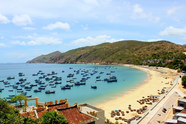
AsemconnectVietnam - It is a general economic zone with key economic sectors being the marine economy, industry, high-quality services and high-tech agriculture
Construction plan of Binh Dinh province region to 2035
1. Scope and limited time for elaboration of the plan:
a) Scope of planning: Scope of research on the administrative boundaries of Binh Dinh Province has a natural area of 6,050 km2. Including 11 administrative units: 01 city, 01 town and 09 districts.
b) Time limit for planning: short-term period up to 2025; Long term up to 2035.
2. Planning nature:
- It is a general economic zone with key economic sectors being the marine economy, industry, high-quality services and high-tech agriculture.
- To be the center of industry, culture, sea tourism, cultural tourism and landscape ecology, trade - service, maritime transport, health care, education and training, scientific and technical application. and the technology of the Central Coast and Central Highlands.
- Being the economic and social exchange center of the central key economic region, the southern central coastal region and the Central Highlands. Gateway to the Central Highlands, Southern Laos, Northeast Cambodia, Thailand to the South China Sea.
- It is a strategic location for defense and security in the South Central region and the Central Highlands.
3. Planning objectives:
a) General objective:
Bringing into full play the advantages of strategic position and potential of marine economy, building the urban-rural system of Binh Dinh province to develop sustainably in socio-economic and environmental fields and ensure security and defense. . Raising the position of the province, creating the spillway to the South Central Coast, Central Highlands and South East Asia.
b) Specific objectives:
- Develop the spatial model of Binh Dinh province to develop flexibly and efficiently. To develop the urban-rural system in a sustainable manner, preserve the ecological environment and suit the trend of integration and readiness to respond to climate change.
- To build a large-scale technical infrastructure and technical works in synchronous connection with urban systems, economic zones and national technical infrastructure systems.
- To build Quy Nhon city into one of the marine economic centers of the country, oriented towards service - sea port - industry - tourism, with a focus on sea port services. The urban centers of Binh Dinh Province and the Southern Central Region and the Central Highlands. Development of Nhon Hoi Economic Zone is an important driving force for socio-economic development.
- Effectively exploiting human, ecological and landscape potential to develop trade, services and tourism in association with environmental protection.
- It is the legal basis for implementation of urban construction planning and specific functional areas; Planning the urban development plan of Binh Dinh province.
Population, urbanization and land for urban construction
a) Population and urbanization:
- By 2025, the population of the whole province will be around 1,704,300, of which: the urban population will be around 751,500; The rural population is about 952,800 people. The urbanization rate is around: 44.1%.
- In 2035, the province's population shall be around 1,914,590, of which: the urban population will be about 930,290; Rural population: 984,300 people. Urbanization rate is around: 48.6%.
b / Forecast on land demand for construction: By the year 2025, about 11,800 ha - 12,500 ha; In 2035 about 18,600 ha - 20,000 ha.
5. Development model and regional spatial structure:
a) Development model:
Binh Dinh Province is divided into 2 areas, including:
- Sub-region No.1 is a general economic development zone covering an area of around 364,146 ha, including: Quy Nhon city, An Nhon town and Tuy Phuoc, Van Canh, Phu Cat, Tay Son and Vinh Thanh districts; Quy Nhon city is the central sub-region. Development orientation: Being a political, economic and cultural center of Binh Dinh province; industrial development, seaport, logistics based on the advantage of regional - national transport hub; develop marine tourism in association with historical culture; Developing specialized training, health education.
- Sub-area 2 is an area of agricultural economic development and hi-tech processing with an area of around 240,911 hectares, including Phu My, Hoai Nhon, An Lao and Hoai An districts; In particular, Hoai Nhon is a sub-regional center. Development orientation: To promote the development of marine economy; agricultural development, eco-tourism.
b) Regional spatial structure:
Consisting of key economic corridors, dynamic urban centers and the following principal landscapes:
- The key economic corridors:
+ The north-south economic corridor along national highway 1, including the urban centers of Quy Nhon, Dieu Tri, Tuy Phuoc, Phuoc Loc, An Nhon, Ngo May, Phu My, Binh Duong, An Tuong Tay and Tang Bat. Tiger, Hoai Nhon.
+ The East-West Economic Corridor along national highway 19, including the urban centers of Quy Nhon, An Nhon, Phuoc Loc, Dieu Tri, Tuy Phuoc and Tay Son.
+ The western corridor along national highway 19C, provincial road 637, including the urban centers of Van Canh, Canh Vinh, Tay Son, Vinh Thanh, An Lao and An Hoa.
+ Eastern corridor along National Highway 1D, provincial road 639 includes chain of urban areas: Quy Nhon, Cat Tien, Cat Khanh, My Chanh, My Thanh, Hoai Nhon.
Regional centers for dynamics of urban development include Quy Nhon, An Nhon, Hoai Nhon, Tay Son, Cat Tien and Nhon Hoi economic zone.
- Landscapes: The landscape of forestry production in the West, the landscape of agriculture adaptation to climate change in the East; conservation of Thi Nai, Thi Gi, Tra đầm mangrove and landscape along the large rivers and lakes in the area; To create landscapes and green corridors interlaced between urban and industrial areas.
6. Orientations for regional spatial development:
- Spatial development of Binh Dinh Province in close relationship with the development orientations of the Greater Mekong Subregion, Quy Nhon City - Nhon Hoi Economic Zone is an important growth pole connecting the central regional and national economic centers on North-South and East-West corridors (National Highway 1, National Highway 19, North-South Highway).
- In the period up to 2035, the urban system of Binh Dinh province will develop economically, socially and environmentally. Appearance of urban areas and rural residential areas bearing bold cultural identities and diversified natural landscape in the South Central region.
Economic: Restructure the urban distribution network, promote the development of Nhon Hoi economic zone from the multi-sectoral industrial economy to the knowledge economy of creative, high technology. To build urban focal points to support the development of seaports, airports, logistic centers, etc. To protect the areas with landscapes and culture of Thi Nai, De Gi, Tra O and Bay lakes. Quy Nhon, Phuong Mai peninsula, prioritize the development of high-class tourism services and attract the world-class corporation to invest in high quality tourism projects. Rural areas, developing commodity economy based on high technology agriculture.
Social: Upgrading and supplementing social security services in the northern and western districts of Binh Dinh. To create conditions for rural people to move into urban centers; To exploit cultural factors and new agriculture in association with the development of small and medium urban centers, with the construction of civilized and modern rural population spots aimed at enhancing the quality of life of rural inhabitants.
On the environment: To delineate areas prone to natural calamities to control the expansion of urban centers or develop new settlements, especially in Tuy Phuoc district, around Thi Nai lagoon, downstream Lai Giang River, Con River, Ha Thanh River. Encourage the sustainable urban development of the environment such as green urban model, smart urban, urban renewable energy use in housing design, public works and urban infrastructure.
7. Orientations for development of the system of urban centers and rural population quarters:
a / Orientations for development of the urban system:
- By 2025, Binh Dinh province will have 17 urban centers, including 01 grade-I urban center (Quy Nhon city); 01 grade-III urban center (An Nhon city); 02 grade-IV urban centers (Hoai Nhon, Tay Son); 10 existing grade V cities (Vinh Thanh, Van Canh, An Lao, Tang Bat Ho, Phu My, Tuy Phuoc, Dieu Tri, Binh Duong, Ngo May, My Chanh); 03 new urban centers (Cat Tien, Phu Cat, Phuoc Hoa, Tuy Phuoc, An Hoa, An Lao).
- By 2035, Binh Dinh province will have 22 urban centers, including 01 class city (Quy Nhon city); 02 grade-III urban centers (An Nhon city, Hoai Nhon urban center); 02 grade-IV urban centers (Tay Son, Cat Tien), 10 existing grade-V urban centers (Vinh Thanh, Van Canh, An Lao, Tang Bat Ho, Phu My, Tuy Phuoc, Dieu Tri, Binh Duong, Ngo May, Chief); 07 new grade-V urban centers (My Thanh, Phu My, Cat Khanh, Phu Cat, Phuoc Loc, Tuy Phuoc, An Tuong Tay, Hoai An, Canh Vinh, Van Canh, Phuoc Hoa Phuoc district, An Hoa district, An Lao district).
b / Orientations for development of rural population quarters:
The distribution of rural population in Binh Dinh is based on the traditional settlement history, the orientation of agricultural, forestry and fishery production and the spatial development of suburban areas. Strengthening basic infrastructure for production and social welfare for rural settlement in coastal, midland and mountainous areas of the province. Study on building rural adaptation points to adapt to climate change. Connect rural areas to urban systems and infrastructure networks throughout the province. To develop commune centers and centers of commune clusters into new service centers in association with agro-forestry and fishery production zones, small- and medium-sized industrial parks, cottage industry and handicraft villages and craft villages. and meet the criteria for new rural construction.
8. Orientations for development of economic infrastructure system:
a) Orientations for industrial development:
- Development of settlements associated with industrial parks and clusters in line with approved industrial development plannings.
- Estimated area of land for construction of industrial zones and clusters in the province by 2035 is about 6,042 ha, in line with approved industrial development plan in the province.
- Distribution of industrial zones:
+ The area along national highway 19 and Quy Nhon city includes Quy Nhon city, An Nhon city and Tay Son and Tuy Phuoc districts. To develop hi-tech industries, shipbuilding, chemical products, industry, manufacture and assembly of electricity, electronics, textiles, consumer industries, supporting industries, etc.
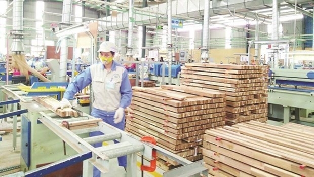
+ The coastal plain and along national highway 1 include Hoai Nhon urban area and districts of Phu My and Phu Cat. To develop mineral processing industries, wood processing, seafood processing, garment ... To invest in and efficiently exploit fisheries processing centers and fishery logistic services in Vinh Loi Phu My district, De Gi district (Phu Cat district) and Tam Quan (Hoai Nhon city).
+ Midland and mountainous areas include An Lao, Hoai An, Vinh Thanh and Van Canh districts. To form and develop specialized areas for cultivation of concentrated industrial trees, forestry, pulpwood, specialty forestry and husbandry to create raw materials for processing plants.
Social: Upgrading and supplementing social security services in the northern and western districts of Binh Dinh. To create conditions for rural people to move into urban centers; To exploit cultural factors and new agriculture in association with the development of small and medium urban centers, with the construction of civilized and modern rural population spots aimed at enhancing the quality of life of rural inhabitants.
On the environment: To delineate areas prone to natural calamities to control the expansion of urban centers or develop new settlements, especially in Tuy Phuoc district, around Thi Nai lagoon, downstream Lai Giang River, Con River, Ha Thanh River. Encourage the sustainable urban development of the environment such as green urban model, smart urban, urban renewable energy use in housing design, public works and urban infrastructure.
7. Orientations for development of the system of urban centers and rural population quarters:
a / Orientations for development of the urban system:
- By 2025, Binh Dinh province will have 17 urban centers, including 01 grade-I urban center (Quy Nhon city); 01 grade-III urban center (An Nhon city); 02 grade-IV urban centers (Hoai Nhon, Tay Son); 10 existing grade V cities (Vinh Thanh, Van Canh, An Lao, Tang Bat Ho, Phu My, Tuy Phuoc, Dieu Tri, Binh Duong, Ngo May, My Chanh); 03 new urban centers (Cat Tien, Phu Cat, Phuoc Hoa, Tuy Phuoc, An Hoa, An Lao).
- By 2035, Binh Dinh province will have 22 urban centers, including 01 class city (Quy Nhon city); 02 grade-III urban centers (An Nhon city, Hoai Nhon urban center); 02 grade-IV urban centers (Tay Son, Cat Tien), 10 existing grade-V urban centers (Vinh Thanh, Van Canh, An Lao, Tang Bat Ho, Phu My, Tuy Phuoc, Dieu Tri, Binh Duong, Ngo May, Chief); 07 new grade-V urban centers (My Thanh, Phu My, Cat Khanh, Phu Cat, Phuoc Loc, Tuy Phuoc, An Tuong Tay, Hoai An, Canh Vinh, Van Canh, Phuoc Hoa Phuoc district, An Hoa district, An Lao district).
b / Orientations for development of rural population quarters:
The distribution of rural population in Binh Dinh is based on the traditional settlement history, the orientation of agricultural, forestry and fishery production and the spatial development of suburban areas. Strengthening basic infrastructure for production and social welfare for rural settlement in coastal, midland and mountainous areas of the province. Study on building rural adaptation points to adapt to climate change. Connect rural areas to urban systems and infrastructure networks throughout the province. To develop commune centers and centers of commune clusters into new service centers in association with agro-forestry and fishery production zones, small- and medium-sized industrial parks, cottage industry and handicraft villages and craft villages. and meet the criteria for new rural construction.
8. Orientations for development of economic infrastructure system:
a) Orientations for industrial development:
- Development of settlements associated with industrial parks and clusters in line with approved industrial development plannings.
- Estimated area of land for construction of industrial zones and clusters in the province by 2035 is about 6,042 ha, in line with approved industrial development plan in the province.
- Distribution of industrial zones:
+ The area along national highway 19 and Quy Nhon city includes Quy Nhon city, An Nhon city and Tay Son and Tuy Phuoc districts. To develop hi-tech industries, shipbuilding, chemical products, industry, manufacture and assembly of electricity, electronics, textiles, consumer industries, supporting industries, etc.
+ The coastal plain and along national highway 1 include Hoai Nhon urban area and districts of Phu My and Phu Cat. To develop mineral processing industries, wood processing, seafood processing, garment ... To invest in and efficiently exploit fisheries processing centers and fishery logistic services in Vinh Loi Phu My district, De Gi district (Phu Cat district) and Tam Quan (Hoai Nhon city).
+ Midland and mountainous areas include An Lao, Hoai An, Vinh Thanh and Van Canh districts. To form and develop specialized areas for cultivation of concentrated industrial trees, forestry, pulpwood, specialty forestry and husbandry to create raw materials for processing plants.
- To invest in completing infrastructures in Phu Tai, Long My, Nhon Hoa, Hoa Hoi and Nhon Hoi economic zones. To build infrastructures of Cat Trinh industrial zone (Phu Cat district), Bong Son (Hoai Nhon urban center), Binh Nghi - Nhon Tan urban center (Tay Son urban center). To form an urban-industrial-service complex in Canh Vinh urban center (Van Canh district). To expand existing industrial parks and plan new industrial parks in other favorable locations in the region.
b) Orientations for tourism development:
- To develop 03 focus groups on the basis of advantages of each region in the province, including:
+ Quy Nhon tourist cluster and its vicinity include tourist sites in Quy Nhon, An Nhon, Tuy Phuoc, Van Canh and Phu Cat districts. To develop high-quality sea-island tourism, spiritual tourism, visit architectural relics, religious and scenic spots; science tourism in combination with Ghenh Rang science and education space (creative valley), ecotourism in association with Thi Nai Lagoon.
+ Tay Son tourism cluster and its vicinity include tourist sites in Tay Son urban area and Vinh Thanh district. To develop tourist products, visit historical-cultural relics, architectural art; festivals, spirituality; education, gratitude; visit, experience the village; study ecology, sightseeing, ...
+ Hoai Nhon tourism cluster and its vicinity include tourist sites in Hoai Nhon urban area and districts of Phu My, Hoai An and An Lao. Developing tourist products, bathing; Visiting and exploring historical-cultural relics; sports, entertainment, adventure; cuisine.
- To build Quy Nhon city as a tourist center of the whole province and one of the tourist centers in the South Central Coast. Additional supporting centers include Hoai Nhon and Tay Son.
To develop Phuong Mai - Nui Ba tourist area with the area of 2,500 hectares, becoming a national tourist resort with sea ecological values and bearing the cultural mark of Binh Dinh province. Orientation of development of the relic complex associated with the Tay Son uprising, Quang Trung Museum and Tay Son Tam Kiet Temple into a national tourist site.
- Creating regional tourism routes based on linking the natural and cultural heritage of Champa and Tay Son.
c / Orientations for trade and service development:
- To develop regional financial, trade and service centers in Quy Nhon, An Nhon, Hoai Nhon and Nhon Hoi economic zones. To develop a system of trade, service and modern distribution, combining with the renovation and construction of new market systems in the city areas, townships and new urban centers and industrial parks of the province.
- To develop regional and provincial depots in Quy Nhon, An Nhon, Hoai Nhon and Tay Son combined with seaports, airports and key economic corridors of national highways. 1, National Highway 19 and interregional trade routes.
- To form a regional fair and exhibition center in Quy Nhon city. In An Nhon city, Hoai Nhon urban area, Tay Son has formed and developed clusters or fairs and exhibitions, promotion centers and commodity exchanges that play the role of intra-regional and inter-regional connectivity. Binh Dinh with neighboring areas. To develop wholesale trade centers in agro-forestry-fishery areas of large scale such as agricultural and forestry marketplaces in Hoai Nhon, Tay Son and fishery markets in Tam Quan (urban centers). Hoai Nhon), De Gi (Phu Cat district).
d / Orientations for agro-forestry-fishery development:
- Agricultural area: To develop hi-tech agriculture, adapt agriculture to flood-prone areas and saline intrusion. Protecting agricultural land in suburban areas. To develop large-scale agricultural areas in An Nhon city, Tuy Phuoc district and Phu My district. Building adaptive agricultural production to climate change in the Eastern seaboard. Set up specialized farming areas for commodity agricultural commodities for processing industries, export and consumption. Upgrading and building new plant breeding centers, high technology farming, clean production and safety in suburban central cities. Development of models of agricultural production combining ecotourism.
- Forestry: To protect and develop special-use forests of the western districts, An Toan Nature Reserve, An Lao district; The protection corridor belongs to Con River, Ha Thanh, La Tinh, Lai Giang. To protect the system of protection forests and coastal and mangrove forests in Quy Nhon city, Hoai Nhon city and Tuy Phuoc, Phu Cat and Phu My districts.
- Fishery area: To develop a specialized area for aquaculture with the application of biotechnology and production of breeding breeds suited to each region. Strengthen fishing activities onshore and offshore, marine products of high economic value, serving seafood processing and exporting. Develop fishery logistic services in Tam Quan (Nhai Nhon urban area), De Gi (Phu Cat district), high-tech aquaculture center in Phu My district.
9. Orientation for development of social infrastructure system:
a) Education and training:
To form a regional center for scientific research, education and training in Quy Nhon city. Continuing to invest and expand the interdisciplinary science and education center in Quy Nhon City, contributing to the promotion of basic scientific research in Vietnam as well as the training of high quality human resources for the region and the region. area. To build professional secondary schools and colleges to train in the fields of technology such as An Nhon city, Hoai Nhon city, Tay Son and Cat Tien. To plan the training of multi-level training schools in small urban centers in rural areas.
b) Health:
To form a complex of high-quality medical works in Quy Nhon city. To invest in the construction of new ones, to combine the upgrading and improvement of specialized and general hospitals and the existing centers and clinics in the province. Carry out relocation of health care facilities that may cause pollution from densely populated areas.
c) Culture, physical training and sports:
To develop culture and physical training and sports in the direction of preserving and promoting the national cultural values and becoming the cultural and artistic trademarks of Binh Dinh province. To build a cultural and physical training and sport center and regional exhibition center in Quy Nhon city, An Nhon city, Hoai Nhon city. To build cultural houses, children's houses, physical training and sport centers, libraries in the centers of district capitals. Restoration and embellishment of historical and cultural relics ranked at national and provincial level.
10. Orientation of distribution of conservation areas in natural landscape areas:
- To build and expand the An Toan natural reserve of An Lao district on a national scale with a total area of 26,050 ha. To build a biodiversity corridor linking with An Thoi Nature Reserve with Kon Chu Rang Nature Reserve (Gia Lai Province) and Tay Ba To Nature Reserve (Quang Ngai Province).
- To build conservation zones, landscape protection zones and provincial-level nature reserves on the basis of conservation and sustainable development of important natural ecosystems, species, gene sources, precious and rare species. Binh Dinh Province, including: Species - Landscapes habitat Trao lagoon, Landscape protection of Ba mountain, Phu Cat district; Landscape conservation area Nguyen Hue orange orchard, Vinh Thanh district; Quy Hoa - Quynhon Protected Landscape Area; Thi Nai Lagoon Nature Reserve, Quy Nhon Lake Landscape Protection Area, Quy Nhon City.
11. Orientations for development of regional technical infrastructure systems:
a) Traffic:
- Road:
+ North-South expressway, Quy Nhon - Pleiku line, coastal patrol road (implemented in accordance with planning and projects approved by competent authorities).
+ National highways, provincial roads:
. Connecting national highways and provincial roads in the area to create a continuous network and connection with the national highway system, contributing to improving the transport capacity of the road network.
. To upgrade and renovate national highway 1, national highway 1D, national highway 19, national highway 19B and national highway 19C up to grade-I, level-II and grade-III road standards with 4-6 lanes.
. To upgrade the provincial roads and district roads up to the grade-V and grade-III road standards, depending on the requirements of each section. To build new provincial roads: Phu Phong - Bong Son road; Phu Phong - Vinh Thanh Street; An Lao - Bong Son road; Phu My - Vinh Thanh; Hoai An - Vinh Thanh road; Hoai Nhon - Gia Lai road; Tay Son - Vinh Thanh - An Lao.
. Coastal roads: To comply with the detailed planning of coastal roadways approved by the Prime Minister in Decision No. 129 / QD-TTg of January 18, 2010, ensuring the minimum level of grade III.
+ Urban and rural transport:
. To build the urban transport system in line with the specialized plannings and urban plannings, ensuring the interconnection and interconnection between the urban transport system and the regional and national transport networks. .
. To invest in the development of rural transport system in the region, ensuring the criteria for building new rural areas, reaching 100% of grade A - rural traffic; To connect with provincial roads and national highways to meet the demand for transport and development of rural agriculture modernization.
- Railway: Upgrading the existing North-South railway line; To upgrade Dieu Tri gas station into Quy Nhon general station; 02 new logistics stations in Phuoc Loc and Canh Vinh. To prepare the necessary conditions for step by step construction of the new North-South high-speed rail route running through Binh Dinh.
- Airways: To upgrade and expand Phu Cat airport according to the planning on aviation transport till 2020 with a view to 2030.
- Waterway:
+ Port: To comply with the planning on development of Vietnam's seaport system up to 2020 with a vision after 2030. To build Nhon Hoi port which is a specialized port serving directly industrial establishments and services. great. To upgrade the wharf of Tam Quan (Hoai Nhon urban center) and De Gi (Phu Cat district) to service fishing and boat anchorage services.
+ Inland waterways: To upgrade and renovate main waterway lanes up to technical grades according to regulations such as De Gi - Tam Quan, De Gi - Quy Nhon, Tam Quan - Quy Nhon.
b) Technical preparation plan:
- To control the construction altitude for urban centers according to criteria for ensuring flood safety and anti-landslide response to climate change. To manage the construction elevations and major axis of the area (Con river and Ha Thanh river, La Tinh river, Lai Giang river); Upgrading and building water reservoirs upstream to control downstream floods; open the river, river mouth; To build a system of embankment works against river bank erosion.
- To complete water drainage systems for urban centers, to reach 80-100% of urban roads in urban centers with rain water drainage sewers, 70% of urban roads with rain water drainage sewers.
- Measures for natural disaster prevention and control: Prepare a project on natural disaster prevention and control to assess the situation of natural disasters in the whole province in order to step by step concretize feasible projects to remove people from areas affected by natural disasters.
c) Water supply planning:
- Water sources: The underground water source is mainly exploited in the areas downstream of Ha Thanh river, Con river, Lai Giang river ... By 2025, limiting the use of underground water and by 2035 First, use surface water.
- Water supply demand:
By 2025, the total demand shall be 304,000 m3 / day and night, of which the urban and tourist areas shall be 156,000 m3 / day; industrial capacity is 50,000 m3 / day; Rural area is 98,000 m3 / day.
By 2035: Total demand is 400,000 m3 / day, of which urban and tourist areas is 231,000 m3 / day; industrial volume is 98,000 m3 / day; Rural areas are 71,000 m3 / day.
- Water supply solutions:
+ To renovate and raise the capacity of 10 water plants: Tuy Phuoc (Tuy Phuoc district), Cat Khanh (Phu Cat district), Phu Phong (Tay Son urban center), Binh Duong, Phu My, My Chanh and My Thanh (Phu district). US, Bong Son (Hoai Nhon), Tang Bat Ho, An Tuong Tay (Hoai An district). To build seven new water plants: Quy Nhon city, An Hoa (An Lao district), Ngo May, Cat Tien (Nhon Hoa district), Nhon Hoa lake, An Nhon city, Canh Vinh (Van Canh district).
Maintaining good water supply facilities of good quality; To maintain and upgrade the system of works to meet the requirements of rural water supply; To prioritize the construction of concentrated water supply systems in densely populated areas and coastal plain communes.
d) Power supply planning:
- Maximum power demand: By the year 2025 is 983 MW; By 2035: 1,638 MW.
- Power plant: using power from the following hydroelectric plants: An Khe, capacity of 160 MW; Vinh Son, capacity 2x33 MW; Vinh Son 5, capacity of 28 MW; Tra Xom, capacity of 20 MW; Binh Dinh, capacity 9.9 MW; Tien Thuan, capacity 9.5 MW; Van Phong, capacity of 6 MW. Development of new and renewable energy (solar, wind power, etc.) projects according to the local electricity development plan.
- 500 kV grid: build new Binh Dinh 500 kV station, capacity (2x600) MVA; Van Phong 500 kV line - Binh Dinh and the branch of 500 kV Binh Dinh.
- 220 kV grid; To build three 220 kV transformer stations, including Phuoc An 220 kV substation, a capacity of 2x125 MVA; Phu My 220 kV transformer station, capacity (2x125) MVA; 220 kV transformer station Nhon Hoi, capacity 250 MVA.
Raise the capacity of Quy Nhon 220 MVV transformer station (2x250). To build the dual-quart 220 kV line of Quy Nhon - Quang Ngai; a 220 kV turn-off branch to supply electricity for Phu My 220 kV substation, Phuoc An 220 kV substation; 220 kV double circuit Quy Nhon - Nhon Hoi; 220 kV Quy Nhon - Phu Yen route; 500 kV Binh Dinh - Nhon Hoi and 500 kV Binh Dinh - Phuoc An - Phu My substations.
- 110 kV power grid: To build 23 110 kV transformer stations to supply electricity for additional loads with a total capacity of 1164 MVA; Renovate and expand the capacity of 8 110 kV stations with the total capacity of 316 MVA; To build 238 km of 110 kV transmission lines and renovate 338.5 km of 110 kV transmission lines.
e) Passive telecommunications planning:
- Communication needs: By 2025, 532,000 subscribers; By 2035: 651,000 subscribers.
- Switching: By the year 2035, the number of subscribers in the province is 651,000, with the current capacity of about 366,500 subscribers. It should be installed and expanded with 295,500 subscribers.
- Transmission: Upgrade existing transmission axes with advanced transmission technology of the following axes: Quy Nhon - Tuy Hoa; Quy Nhon - Tuy Phuoc - Phu Cat - Phu My - Hoai Nhon - An Lao; Quy Nhon - Nhon Hoi - Cat Tien; Phuoc Son - Cho Dinh; Quy Nhon - Van Canh - Tay Son - Vinh Thanh - Hoai An - Hoai Nhon.
- Peripheral network: Undertake the underground construction of Quy Nhon city center, Hoai Nhon urban area and new urban area; For urban, rural and mountainous areas using dynamic cables; Perimeter networks are required to share infrastructure, not allowing multiple cable routes to be buried on a route.
- Internet: Broadband Internet access in two modes via local and wireless cable networks.
- Postal: The post office network is still organized in three levels, including post offices of grade I, II and III; Maintaining the number of post offices, upgrading investment in modern equipment, flexibility in exploitation for efficient use of resources.
e) Waste water drainage, solid waste management and cemetery:
- To drain off waste water:
+ Waste water drainage: The total volume of domestic daily-life waste water and tourist services will reach 182,000 m3 / day by 2025 and 275,000 m3 / day by 2035. Minimum collection rate of 80%. The volume of industrial waste water by 2025 is 74,000 m3 / day and by 2035 it is 118,000 m3 / day. Collection rate reached 100%.
+ Quy Nhon city: To build a separate water drainage system, using 02 existing treatment stations: 01 station with a capacity of 28,000 m3 / day, with an area of 12,0 hectares and a capacity of 4,300 m3 / scale of about 5 hectares.
+ Nhon Hoi economic zone, Cat Tien urban center: To use separate water drainage system. Construction of 01 Nhon Hoi treatment plant, capacity of 10,000 m3 / day, scale of 7 ha and 01 treatment plant in Cat Tien, capacity of 7,000 m3 / day, scale of 5.0 ha.
+ An Nhon city and Hoai Nhon urban center: Use separate drainage system. To build wastewater treatment stations for each urban center with a capacity of between 3,000 and 15,000 m3 / day, with a scale of around 5-10 ha / treatment station.
+ Other cities: Select the form of wastewater treatment by the lakes. It is expected to build from 1 to 2 treatment stations for each urban capacity of 1,000 - 6,000 m3 / day, scale from 1 to 3 hectares / treatment station.
+ Industrial waste water is treated separately by each industrial zone.
- Solid waste management:
+ Estimated volume of daily-life and tourist solid waste incurred up to 2025 will be around 1,350 tons / day and by 1,835 tons / 1,850 tons / day. Health solid waste will reach about 8.0 tons per day by 2025 and about 11.0 tons per day by 2035. Industrial solid waste will reach 670 tons per day by 2025 and about 1,300 tons per day by 2035.
+ The rate of daily-life, medical and industrial solid wastes shall reach 95-100%.
+ To build three regional solid waste treatment zones: one solid waste treatment plant of Long My, Quy Nhon city with a capacity of 8,000 tons / day, of about 61 hectares; 01 solid waste treatment plant in Cat Nhon commune, Phu Cat district, capacity of 1,500 tons / day, scale of 30 - 70 ha; Hoai Nhon urban solid waste treatment plant, capacity of 200 tons / day, scale of 15-20 ha.
- Cemetery:
+ To build 02 centrally-run cemeteries, including 01 cemetery in Cat Nhon commune of Phu Cat district with an area of around 45 hectares; 01 cemetery in Bui Thi Xuan ward, Quy Nhon city, about 68 ha.
+ An Nhon city and Hoai Nhon urban area: To build concentrated cemeteries with the size of 15 - 17 ha / 01 urban area.
+ Other urban centers: To renovate and expand the concentrated cemeteries of between 2 and 5 ha / 01 urban center.
+ Rural areas: Closely polluting cemeteries, not enough safe distance for environmental sanitation. To demarcate boundaries and renovate existing cemeteries up to standards.
g) Strategic Environmental Assessment:
- To protect the marine and coastal environment of Binh Dinh Province. Develop and implement solutions for coastal mangrove rehabilitation to minimize the adverse impacts of urban and industrial development on the marine environment and the lagoon. Strictly manage the watershed protection forest and the biosphere reserve to protect water sources. Protection and development of green spaces, protection forests, production forests, green corridors along Con River, Ha Thanh, La Tinh, Lai Giang ... Limited development in flood drainage corridors, activities This will cause changes in the flow of water, resulting in unsafety to residential areas and infrastructure.
- Building active solutions to prevent and respond to climate change in the region; flood and salinity intrusion prevention measures in Sub-Area 1 and coastal areas. Increasing the area of trees and water surface increases the drainage capacity and regulates the climate. Enhance the use of clean energy and renewable energy; reduce pollution sources, greenhouse gas emissions; Adaptation to climate change in urban-rural development. To renovate and synchronously build urban water drainage systems. Development of forest spaces linked to green agrarian areas, theme parks, open spaces of urban areas.
- Develop an environmental management and control program for major river basins in the region. Develop a program to control environmental pollution caused by wastes from urban centers, industrial clusters, transportation ... To build a system for monitoring environmental quality of areas, monitoring systems and scenes Early warning of the impact of climate change such as flood, saline intrusion, sea level rise.
12. Priority programs and projects:
- Urban construction and development: To formulate urban development programs for the whole province. To build Cat Tien urban centers (Phu Cat district), Phuoc Hoa (Tuy Phuoc district), An Hoa (An Lao district). Investment and upgrading of An Nhon, Hoai Nhon, Tay Son. Construction of material facilities of Nhon Hoi Economic Zone.
- Technical infrastructure: Prioritize the development of technical infrastructure frameworks connected with the national and regional systems such as: upgrading national highway 1, national highway 19, national highway 19B, national highway 19C; To upgrade, expand and build provincial roads in order to strengthen the connection with national highways and inter-regional routes; upgrading Phu Cat air port, building Quy Nhon station, expanding Quy Nhon port. Develop flood control projects in coastal districts and cities, inter-regional irrigation and flood control projects, and formulate urban water drainage planning for the province. Construction and upgrading of provincial water plants. To build and complete a regional solid waste treatment area in Phu Cat district.
- Regarding social infrastructure: To invest in key projects to invest in regional centers for health, education and training and cultural and physical training in the suburban centers.
- On trade - services, tourism: To invest in big projects in trade and service in concentrated areas of urban - industrial development and key growth poles in association with important traffic hubs. . To prioritize investment in high-end tourism projects in Quy Nhon city and Nhon Hoi economic zone. To invest in the development of Tay Son urban center into a regional cultural tourism center in association with Tay Son - Nguyen Hue historical history.
- Regarding agricultural and rural economic development: To prioritize the investment in hi-tech agricultural parks, hi-tech cultivation and hi-tech breeding zones. To develop large-scale specialized cultivation zones of industrial plants, high-quality rice areas and fruit trees of high economic value.
Program on conservation and development of Vietnamese craft villages in a period of 2021 - 2030
Implementation plan of marine aquaculture development project in Ninh Binh province to 2030 with a vision to 2045
Plan on implementing national environmental protection strategy to 2030 with a vision to 2050 in Kien Giang province
Plan on implementing Decision No. 327/QD-TTG dated March 10, 2022 of the Prime Minister approving the project on developing sustainable and effective wood processing industry in the period of 2021-2030 in Gia Lai province
Action plan on implementing strategy of sustainable agricultural and rural development in a period of 2022-2030 with a vision to 2050 in Hanoi city
Plan on implementing Decision No.923/QD-TTG dated August 2, 2022 of the Prime Minister approving science and technology program for new rural construction in a period of 2021-2025 in Vinh Long province
Plan on implementing strategy of sustainable agricultural and rural development in Bac Kan province in a period of 2021 - 2030 with a vision to 2050
Action plan on implementing livestock development strategy in a period of 2022-2030 with a vision to 2045 in Hanoi city
Implementation plan of Vietnam's forestry development strategy for a period of 2021-2030 with a vision to 2050 in Gia Lai province
National master plan in a period of 2021-2030, vision to 2050
Program on strengthening environmental protection, food safety and rural clean water supply in building new countryside in a period of 2021-2025
Digital transformation program on building new countryside, towards smart new countryside in a period of 2021 - 2025
Rural tourism development program on new rural construction in a period of 2021 - 2025
Project on development of trade, e-commerce systems and border trade in Binh Phuoc province in a period of 2021-2025, orientation to 2030
Plan on implementing Decision No. 327/QD-TTG dated March ...
Concretize viewpoints, objectives, tasks and solutions of the plan in accordance with practical conditions of the locality, associating ...Plan on implementing national environmental protection ...
Implementation plan of marine aquaculture development ...
Program on conservation and development of Vietnamese ...
Plan on improving quality of human resources to 2025 and ...

Efforts taken to turn culinary culture into national ...
The Vietnam Cuisine Culture Association (VCCA) is taking steps to implement a project to build and develop Vietnamese culinary culture ...Vietnamese cuisine making a name for itself with ...
Vietnam advance to next round of AFC U20 Women’s Asian Cup
Cultural tourism and traditional values promoted through ...
