


Master plan on construction of Van Don economic zone to 2040
Tuesday, March 31,2020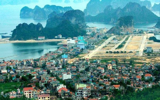
AsemconnectVietnam - Multi-sector, multi-field marine economic zone, entertainment industry center with casino, high-class sea and island tourism, general services; is the gateway for international trade, creating unique, distinctive and modern products with high quality, international brands and competitiveness
1. Scope and scale of the plan
a) Scope of planning research on the whole natural area of Van Don district, Quang Ninh province.
b) Planning scale: The natural area of Van Don district is about 2,171.33 km2. In which: natural land area is 581.83 km2, sea area is 1,589.5 km2.
2. Characteristic
- Multi-sector, multi-field marine economic zone, entertainment industry center with casino, high-class sea and island tourism, general services; is the gateway for international trade, creating unique, distinctive and modern products with high quality, international brands and competitiveness;
- Urban of green, modern, smart and sustainable islands;
- The region has an important position in terms of national security and defense.
3. Forecast of population and land size
- By 2030, the population is about 140,000 - 200,000 people (permanent population is about 90,000 - 140,000 people, the population is about 50,000 - 60,000 people). Demand for land use to build functional areas is about 5,500 hectares.
- By 2040, the population of about 300,000 - 500,000 people (permanent population of about 180,000 - 300,000 people, the population converted about 120,000 - 200,000 people). Demand for land use to build functional areas is about 12,050 ha.
4. Space development orientation
a) Development zoning:
The spatial development structure of Van Don economic zone is divided into 2 regions, including Cai Bau island and Van Hai archipelago, with orientations into 5 development belts including: (1) High-class eco-resort; (2) Ecotourism belt associated with protection of natural heritage; (3) Service urban area, culture and entertainment area (east of Cai Bau island); (4) Service belt, hi-tech industrial trade and logistics (the western area of Cai Bau island); (5) Western development reserve belt (in the boundary of Cam Pha city and Tien Yen district).
- For Cai Bau island: To develop concentratedly the main functional areas of the urban and economic zones. Cai Bau Island is divided into the eastern regions (Cai Rong area), the western region (Van Don airport area) and the northern area (Mui Chua - Van Hoa port), with specific functions such as: after:
+ The eastern area of Cai Bau island focusing on urban development, tourism and entertainment services; long-term exploitation of submerged areas to create land funds for development of functional areas of greenery, cultural centers, public urban services, tourist services ...;
+ The western area of Cai Bau island to develop functional areas for transportation, logictics, commercial, industrial and other support services associated with dynamic exploitation, namely Van Don international airport and high way. Ha Long - Van Don - Mong Cai expressway;
+ The northern area of Cai Bau island to develop functions on port services, high-class resort resorts and hi-tech industrial production. Development associated with hilly terrain characteristics in the area.
- For Van Hai archipelago: To develop high-class resort and eco-tourism services, hi-tech agricultural production in association with the conservation of ecological landscapes and biodiversity in the region. Restricting population development in some existing islands (Canh Cuoc, Tra Ban, Ngoc Vung, Cong Dong - Cong Tay). Arranging a common public service center on Canh Cuoc, Ngoc Vung and Tra Ban islands. With the functional partitions as follows:
+ The northern area within the scope of Bai Tu Long National Park is strictly preserved according to regulations;
+ The area of the eastern islands (Canh Cu, Ngoc Vung, Van Canh, Tra Ban, Chau Lap, Phuong Hoang, Chang Ngo, Cai Lim) forms high-class tourist resorts combined with entertainment;
+ The western island areas (Dong Chen, Tra Ban and The Vang) to develop eco-tourist resorts in combination with hi-tech agricultural production;
+ Stone islands and eco-islands allow tourism exploitation and restrict construction activities.
b) Spatial development orientation of areas
Cai Bau Island is organized into 6 development areas including: (1) Cai Rong area; (2) Welcome gate peninsula area; (3) Airport area (west of Cai Bau island); (4) North Cai Bau area; (5) Northeastern area of Cai Bau; (6) The mountainous area of Cai Bau island. As follows:
- Cai Rong area (in the administrative boundary of Cai Rong town, Dong Xa commune, Ha Long commune and Van Yen commune); is an urban center, a center of mixed services and tourism.
+ Forecast of population size to around 127,000 by 2040 (of which the permanent population is about 90,000). The natural area is about 2,810 hectares, including construction land for functional areas of about 1,850 hectares and other land: 960 hectares.
+ Development orientations: Northern Cai Rong area prioritizes the development of high-class sea tourist service areas, combining entertainment. The central area develops public services for urban and tourism. The southern region develops commercial services and tourism support services. Controlling tall buildings, coastal landscape space, limiting construction on hilly areas; development of high-rise buildings along the road 58m and some central axes facing the sea; increase the area of greenery and public spaces.
- Welcome gate peninsula area (in the administrative unit of Dong Xa commune); is a regional and international commercial, financial and cultural center.
+ Scale: The projected population by 2040 is around 65,000 (of which the permanent population is about 45,000). The natural area is about 750 hectares, including land for constructing functional areas of 510 hectares and other land of 240 hectares.
+ Development orientations: To form a new key development area for Van Don economic zone, based on artificial island structure, with modern high-rise architectural complexes with space for greenery and water surface. Controlling coastal landscape space, prioritizing public works, tourism services and square space in coastal areas,... Studied after the land fund of functional areas has been implemented, basically complete the investment; when conducting research and development, to assess the socio-economic and environmental impacts; comply with the provisions of law on environmental and land protection.
- Airport area (belongs to administrative boundaries of Doan Ket, Binh Dan and Dai Xuyen communes); is a transport hub, international trade services, logistics, logistics; High-tech industry.
+ Scale: The population till 2040 is about 103,000 people (of which the permanent population is about 75,000 and the converted population is about 28,000). The natural area is about 7,130 ha including 3,200 ha for functional areas and 3,930 ha for other areas.
+ Development orientation: Forming a multi-modal transportation center around the airport. To develop a commercial service center north of the airport and a service to the south of the airport. To build a high-tech industrial park to the northeast and a local industrial cluster to the south. Control the height of construction works in the area, ensuring airspace for the airport; develop functional areas with low density, medium height, in harmony with the natural topographic landscape.
- North Cai Bau area (belongs to the administrative boundary of Dai Xuyen and Van Yen communes); is an urban complex of port services, high-class tourism services; industrial park, high technology.
+ Scale: The planned population till 2040 is about 80,000 - 100,000 people (of which: the permanent population is about 60,000 and the converted population is about 20,000 - 40,000). The natural area of 5,000 hectares includes: Construction land of 2,410 hectares of functional areas and other land of 2,590 hectares.
+ Development orientation: To develop the Northern port of Cai Bau island to support large-scale international cargo and passenger transportation. To develop urban tourist services and port services in association with hilly terrain in the region. To form a hi-tech medical park and scientific and technological activities. Controlling urban construction areas, resorts, maintaining natural landscapes and preserving ecosystems.
- Northeastern area of Bau Bau (belongs to the administrative boundary of Van Yen commune); is an entertainment complex with casino and luxury resort, golf, and eco-forest parks.
+ Scale: The projected population by 2040 is around 41,000 (of which the permanent population is about 8,000 and the converted population is about 33,000). Natural land area: 4,250 ha, including: construction land of functional areas 860 ha and other land of 3,390 ha.
+ Development orientations: To develop entertainment and tourist resorts associated with cultural and artistic activities. Exploiting a number of low-slope hillsides to build small-scale resorts to serve the development of resort and entertainment tourism. Control high-rise buildings in the central area, exploiting natural landscape terrain to build functional areas; protect forest ecosystems and coastal natural spaces.
- The mountainous area of Cai Bau island (belonging to the administrative boundary of Doan Ket, Binh Dan, Van Yen, Ha Long, Dong Xa and Cai Rong towns); is a forest development area, combined with development of tourist services and a national defense and security position.
+ Scale: The projected population by 2040 is around 3,000 people (of which, the permanent population will be around 2,000 and the converted population will be around 1,000). Natural area: 7,000 hectares, including 320 hectares of construction land and 6,680 hectares of other land.
+ Development orientation: Protection and development of forestation activities to create ecological landscapes; development of residential areas, forest parks, entertainment, recreation and sport services (golf courses); protect water reservoir. Control tourist service spaces, golf courses; limiting construction activities, leveling hills and mountains, affecting the natural landscape in the area. Studying and building a number of public works and sightseeing spots at high points with favorable views to develop tourism services. Exploiting valleys, areas with good soil conditions to form fruit farms, developing local specialties.
- Van Hai archipelago: Dividing islands into populated islands, tourist islands, agricultural islands and ecological conservation islands.
+ Scale: The planned population until 2040 is around 79,000 (of which, permanent population is about 20,000 and the converted population is about 59,000); natural area about 25,720 ha; The construction land area is about 2,890 hectares
+ Development orientations: To develop forests, diversify forms of tourist services on islands and water surface areas, attaching to specific conditions of each island and each region. To form a number of population quarters, tourist service and trade centers, tourist ports and port logistic zones. Controlling the landscape of the islands; construction of low-rise buildings, low density, harmonizing natural conditions in the area; protect ecological landscape and biodiversity in islands within Bai Tu Long National Park; limiting construction activities, deforestation, sea encroachment.
5. Orientations for development of economic and social infrastructure
a) Orientation for development of economic infrastructure
- Industry: Area of about 1,400 - 1,450 ha (Including the area south of the airport about 420 - 450 ha; the area north of the airport is about 430 - 450 ha and the area of Northern Cai Bau about 520 - 550 ha). Arranging an industrial cluster of about 50 ha in the South of the airport and handicraft spots on Canh Cuoc island (Minh Chau - Quan Lan), Tra Ban to support activities of local trade village production and processing fisheries, fisheries support and other services.
- Commercial services: Area of about 250 - 300 ha. Arranging mixed commercial service centers at the center of functional areas (Bac Cai Bau, Northeast Cai Bau, Canh Cuoc island, Tra Ban island, Ngoc Vung island), attached to traffic hubs. To develop specific commercial service establishments in association with urban centers, tourist resorts and tourist islands to meet tourism development.
- Tourism services: The area of land for developing tourist service areas will be about 2,700 - 2,800 hectares (land area for construction of accommodation establishments will be around 650 hectares, meeting around 65,000 rooms). Arranging concentrated in Cai Rong and Bac Cai Bau areas, combined with the system of accommodation services, entertainment services and at the focal area of passenger ports; Van Hai archipelago will develop a system of high-class resort resorts combined with eco-tourist resorts, tourism to experience nature discovery; forming auxiliary centers on Quan Lan, Ngoc Vung and Tra Ban islands to support tourism services on the islands.
- Develop agriculture towards applying high technology production technology, applying hydroponic and microbiological techniques to adapt to climate change. Building large-scale agricultural production models using land savings. To protect and develop typical local agricultural products such as Cam and Sá sá. Organizing aquaculture activities on the Bay in accordance with the spatial development orientation of the economic zone, limiting negative impacts on the regional ecological environment. Exploitation and use of forest land comply with regulations on forest protection. Protecting the area of special-use forests, ensuring the area of protective forests, converting production forest land into perennial tree planting to create landscapes and serve tourism.
b) Orientations for social infrastructure development
- Head office: Arranging an expected administrative center in Doan Ket commune area with an area of about 10-20 ha; Upgrading and improving the system of head offices, existing agencies to meet short-term needs. Arranging new urban-center administrative centers and housing units to meet the needs of expansion, relocation and areas where the current state does not meet the urban standards.
- Urban and residential areas: About 3,500 ha; concentrated urban areas will be located in Cai Rong area, airport and Bac Cai Bau. Arranging and rearranging existing residential areas and new urban centers to ensure spaces and infrastructure conditions up to grade-2 urban standards. Restricting the development and expansion of population in archipelago islands Vân Hải. Housing development associated with tourism urban projects with modern and synchronous urban infrastructure; develop types of houses for rent, social houses to serve migrant workers, low-income people and tourists when there is demand in the areas. Arranging concentrated resettlement areas with synchronous technical and social infrastructures to meet the needs of population relocation in areas where the socio-economic and infrastructure projects are implemented; village area with low construction density.
- Education: Building a university base of international standards and attracting universities and research institutes to train labor, high quality experts for the region. Arranging the system of upper secondary schools associated with population distribution, ensuring convenient access for people.
- Health: Building 01 international standard hospital with a scale of 6 - 10 ha and a scale of 300 - 500 beds. To build a new high-quality general hospital of around 300 beds and about 3-5 hectares in Bac Cai Bau area. To renovate and upgrade Van Don district's medical center into a regional hospital of 300 beds (2.8 hectares) and build a new hospital on Canh Cu island with a scale of 100-200 beds to serve people and tourists in the islands area.
- Culture, physical training and sports: Building a system of cultural works to attract creative activities, events and services. Arranging cultural works in Cai Rong coastal area - Welcome gate; encouraging projects to develop cultural service centers for common use in the whole economic zone. To preserve and develop existing cultural and historical relics and works and works associated with the history of "Van Don port trade". Develop a system of sports activities, entertainment on the water to serve tourism development.
6. Land use planning
a) Land use exploitation must ensure the following principles:
- For areas planned for tourism development, including land for accommodation areas in tourist resorts, it is necessary to comply with the provisions of the Tourism Law and current regulations;
- Planning areas of functional areas using protective forest land or special-use forests must be special and urgent projects; When implemented, it must comply with the provisions of the Forestry Law;
- Development of construction land in reclaimed areas is only carried out after development land funds according to the planning of functional areas have been used up; When conducting research and development, to assess impacts on socio-economic and environmental landscapes, to comply with law provisions on environmental protection;
- Protect the areas of land, current national defense and security works and areas planned for arrangement of defense and security works. The process of implementing urban development projects and urban infrastructures complies with the coordination regulations, ensuring the objectives of national security and defense.
b) By 2030:
- Land for construction of functional areas will be around 5,500 hectares (accounting for 9.5% of the total natural land area of the islands), including:
+ Land for urban areas and residential areas will be around 1,600 - 1650 ha;
+ Mixed land (not residential) of about 200 - 230 ha;
+ Commercial and service land is about 100-120 hectares;
+ Land for developing tourist resorts is about 900 - 950 ha (including accommodation service land about 150 - 180 ha);
+ Industrial land, high technology about 550 - 600 ha;
+ Training land is about 40-50 hectares;
+ Land for parks and thematic trees of around 500 - 600 hectares;
+ National defense and security land of about 550 hectares;
+ External transportation land about 280 - 300 ha;
+ Land for technical infrastructure, airports and ports of around 500-550 hectares.
- Other land: about 52,663 ha (accounting for 90.5% of the total natural land area of the islands), of which:
+ Cemetery park park is about 80 ha;
+ Agricultural land is about 1,100 hectares;
+ Land for aquaculture is about 1,000 hectares;
+ Forestry land is about 33,980 ha;
+ Other land (water surface, canals, irrigation, unused land, other land) ... about 16,423 ha.
c) By 2040:
- Land for construction of functional areas is about 12,050 ha (accounting for 20% of the total natural land area of the islands). Include:
+ Land for urban areas and residential areas will be about 3,400 - 3,500 hectares;
+ Mixed land (not residential) about 800 - 910 ha;
+ Commercial and service land is about 250 - 300 hectares;
+ Land for developing tourist resorts is about 2,700 - 2,800 ha (of which accommodation service land is about 600 - 650 ha);
+ Industrial land, high technology about 1,400 - 1,500 ha;
+ Training land is about 50 - 60 hectares;
+ Land for parks and thematic trees is about 1,250 - 1,400 hectares;
+ National defense and security land of about 550 - 700 hectares;
+ External transportation land about 600 - 650 ha;
+ Technical infrastructure land, airports, ports around 750 - 800 ha.
- Other land: about 46,133 ha (accounting for 80% of the total natural land area of the islands), of which:
+ Cemetery park park area of about 150 hectares;
+ Agricultural land about 800 hectares;
+ Forestry land is about 32,850 ha;
+ Other land (water surface, canals, irrigation, unused land, development reserve, other land) ... about 11,533 ha.
7. Orientation of technical infrastructure system
a) Traffic planning:
- Outbound traffic
+ Roads: Ensuring a safe corridor and expanding reserves for the Ha Long - Van Don - Mong Cai Expressway. To supplement the connection of national highway 4B from Tien Yen province to provincial road 334, upgrade and expand provincial highway 334. Arranging bus stations to serve external traffic at the airport area, Cai Rong to concentrate means and restrictions Private transport into the central areas of Van Don.
+ Airway: To reserve land fund to meet the needs of expanding Van Don airport in the future; additional supporting infrastructure for airport development and operation; to build helicopter parks and wharves in the areas of Bac Cai Bau, Northeast of Cai Bau, Cong Chao peninsula and islands of Van Hai archipelago.
+ Waterways: To develop Van Hoa - Bac Cai Bau - Mui Chua general port cluster to accommodate ships of 10,000 tons; Bac Cai Bau port will give priority to serving high-class tourist ships. Upgrading and expanding Cai Rong port to support the development of fisheries and storm shelters. To develop the systems of Ao Tien, Van Yen, Cong Chao, Van Hoa, Minh Chau, Quan Lan, Ban Sen, Thang Loi and Ngoc Vung ... ports to serve tourism development and waterway circulation.
+ Railway: To reserve a corridor to develop an urban railway linking Van Don - Cam Pha - Ha Long; high-speed railway along the corridor of Ha Long - Van Don - Mong Cai highway.
- Internal traffic
+ Developing roads connecting the economic zone with the city of Cam Pha. Develop Cai Bau island ring road network and direct links between functional areas to support transportation development. Priority for the development of public transport includes urban railways, public transport and eco-vehicles such as electric cars and bicycles.
+ To renovate and expand the existing roads to meet grade-2 urban standards. For newly built roads, to be planned according to standards, to ensure the use of motorized vehicles, public vehicles and vehicles. pedal and synchronous landscape design. To build different intersections, overpasses and tunnels to connect the two highways of Ha Long - Van Don - Mong Cai. To build bridges across rivers and shallow bridges at major intersections.
+ For islands in the Van Hai archipelago: Prioritizing the use of electric vehicles and bicycles, minimizing the use of motor vehicles and fossil fuels. Build the main island road connecting the regions, connecting with internal roads into each area. To build a bridge connecting Canh Cuoc island and Tra Ban island and a bridge connecting Cong Dong island and Cong Tay island. Arranging cable car route connecting Cai Bau island with Chang Ngo island and Tra Ban island.
+ Arranging car parks in commercial areas, tourist services and regional traffic hubs.
+ Arranging tourist wharves and marinas around Cai Bau island to serve traffic demand and improve marine tourism experience; general port south of the airport serving ship repair, fishing. On the islands of the Van Hai archipelago, marina and marina will be arranged for tourism and cargo transportation of people on the island.
b) Elevation planning:
- Cai Bau island area:
+ Current development area and projects that have been completed leveling and embankment: Maintain leveling ground leveling or leveling locally to suit the current construction situation, ensuring no impact on surface water drainage.
+ Hilly area. When constructing, the local leveling levers should reach a favorable construction slope and avoid causing landslides. Additional measures of retaining walls and talus in critical areas.
+ Newly developed areas: Minimum control height Hxd ≥ 3.5 m.
- Van Hai archipelago area: Minimum controlled height Hxd ≥ 3.5 m.
- Areas adjacent to the sea, directly affected by waves will improve the process of construction, build houses on poles, arrange solutions of breakwater with a minimum height of 4.6 - 5.0 m.
c) Planning on surface water drainage:
Drainage on the principle of gravity, combining separate drainage systems for new construction areas and semi-separate areas, separating wastewater for existing areas.
- Cai Bau Island area: divided into 03 drainage basins:
+ Basin 1: The eastern area of Cai Bau island including Cai Rong town; dredging, embankment solidification, anti-encroachment of existing open drainage axes, direct escape to the sea.
+ Basin 2: The northern area of Cai Bau island, taking advantage of natural aquifers that drain directly to the sea.
+ Basin 3: The western area of Cai Bau island, rainwater is concentrated in Dong Dong, Khe Mai and Khe Ngai reservoirs, then drained to Voi Lon and Ba Che rivers to the sea.
- The islands of the Van Hai archipelago are divided into drainage basins according to the natural terrain to the sea.
d) Electricity supply planning:
- Electricity supply demand till 2040 is about 400 MW.
- High voltage power source and grid:
+ By 2030: Increase the capacity of Van KV 110 KV station from 1x40 MVA to 2x40 MVA. To build a new 110 KV Van Don 2 station with a capacity of 2x63 MVA; 110 KV station of Van Don 3 with a capacity of 1x40 MVA; airport area 110 KV station with a capacity of 1x40 MVA. Constructing 110 KV routes: the route crossing Van Don - 110 KV Van Don 3; 110 KV line supplying electricity to Van KV 2 110 KV station; 110 KV line will branch to 110 KV station area;
+ In the period to 2040: Increase the capacity of Van KV 110 KV station to 2x63 MVA; Van Don 3 station and 110 KV station at the airport area up to 2x40 MVA; building 220 KV Van Don 4 station with a capacity of 2x40 MVA;
+ To reserve reserved land fund to build 220 KV Van Don station with a capacity of 2x250 MVA, meeting future development needs;
+ Underground transportation of existing 110 KV and new construction in the center of economic zone;
+ Encouraging research and use of renewable energy such as solar energy, wind energy, biomass and tides.
- Distribution grid:
+ Medium voltage grid: Use 22 KV medium voltage grid. 22 KV power lines running through functional areas must use underground cables. Other areas use floating lines.
+ Low voltage grid uses underground cables in new urban areas and tourist areas; Use floating electricity lines in suburban areas.
- Lighting: Lighting grid in residential areas is arranged in the same column with low voltage grid. Central area, tourist area using underground cable. Equipping automatic and centralized control system for urban public lighting system.
dd) Planning of contact information:
Constructing and developing passive telecommunications infrastructure system in sync with other infrastructure systems. Complete the construction of a wide area network to serve socio-economic activities. Invest in upgrading the system for state management agencies, administrative and non-business units, ... It is expected to build an Operation Center (IOC) to ensure the processing of information and storage of restored information. long-term service to 2040, building smart cities in Van Don economic zone.
f) Water supply planning:
- Water supply demand till 2040 is 130,000 m3 / day and night.
- Water source:
+ Cai Bau island area: Using surface water from existing reservoirs (Khe Mai lake and Mat Rong lake), to build a new one (Dong Dong lake) and water source from Cam Pha, Tien Yen and Ba Che. . For scattered residential areas, to exploit water from small lakes and groundwater in combination with building rainwater tanks for daily-life needs.
+ Van Hai archipelago area: To exploit water from Long Dinh Lake to supply to Canh Cuoc and Tra Ban islands; Cau Lau lake, granted to Ngoc Vung island; Cong Dong lake will be supplied to Cong Dong and Cong Tay islands. For the remaining islands: Exploiting underground water in combination with using rainwater, building a system to filter seawater into fresh water.
The establishment and management of water source protection corridors for water supply sources (lakes on the island) must comply with current regulations on the establishment and management of water source protection corridors.
- Water plant:
+ Renovating and raising the capacity of water plants: Cai Rong (capacity of 3,000 m3 / day and night); Ngoc Vung (capacity of 2,000 m3 / day and night); Quan Lan (capacity of 10,000 m3 / day and night); Cong Dong (capacity of 1,000 m3 / day and night).
+ New construction of water plants: Dong Dong (capacity of 36,000 m3 / day and night); Khe Mai (capacity of 10,000 m3 / day and night); Tra Ban (capacity of 4,000 m3 / day and night).
+ Supplementing water supply from Tien Yen (capacity of 30,000 m3 / day and night); from Ba Che (40,000 m3 / day and night).
- Water supply network
+ Using ring network design, linkage between water plants to ensure water supply safety.
+ Using the fire fighting water supply network together with the water supply network of the whole economic zone. In addition, factories and industrial enterprises must have their own fire prevention and fighting system to take initiative in fire fighting.
g) Planning on wastewater collection and treatment:
- The total volume of waste water till 2040 is about 85,000 m3 / day and night, of which concentrated industrial waste will be around 17,000 m3 / day and night.
- Domestic wastewater:
Existing residential areas will build a semi-separate drainage system; newly built areas will build separate wastewater drainage systems.
+ Cai Bau island: To be treated according to each cluster of urban centers and functional areas. Constructing concentrated waste water treatment stations with a total capacity of about 55,000 m3 / day.
+ Van Hai archipelago: Use the system to collect and treat waste water scattered in each area. In the long term, depending on the needs, it is possible to link dispersing stations, build concentrated wastewater treatment stations with areas with large amounts of wastewater.
After-treatment daily-life waste water reaches A standard according to the current Regulation on daily-life waste water. Maximum reuse of treated waste water for non-living needs.
- Production wastewater: Wastewater of factories is preliminarily treated in factories and then treated at centralized wastewater treatment stations of industrial parks and complexes up to limit A according to the current regulation when discharged to the outside environment.
- Medical wastewater: Medical waste water needs to be collected and treated separately in each hospital up to the current standards before discharging to a common collection system.
h) Planning on solid waste collection and treatment:
The total solid waste generated by 2040 will be around 720 tons / day and night, of which industrial solid waste will be around 215 tons / day and night.
All types of solid waste must be classified at source. Hazardous industrial and medical solid wastes must be collected and transported separately.
Cai Bau island area: Solid wastes will be transported for concentrated treatment at the solid waste treatment complex of the province.
Van Hai archipelago area: Arranging a separate solid waste incinerator meeting environmental standards on populated islands. The islands are small, only tourism activities focus on the treatment area.
i) Cemetery management plan
- Combining the exploitation and use of existing cemeteries and the use of provincial cemeteries in Hoanh Bo to meet the burial needs of Van Don people.
- For existing cemeteries and graveyards with insufficient hygienic distances, they shall not be expanded, closed or closed.
- Strictly control the construction and architecture of the tombs so as not to affect the general landscape.
- Cai Bau island: Using Doan Ket commune cemetery and Van Yen commune cemetery. To build a new cemetery park in Dai Xuyen commune, expected scale of 50-90 ha. Combined cremation technology includes cremation, one-time cremation, cremation and cremation. Renovating and building funeral parlors according to partitions to serve the needs of the people.
- Van Hai archipelago: Arranging concentrated graveyards on populated islands.
8. Strategic environmental assessment
a) Main solutions to environmental protection:
Using renewable energy; give priority to developing green architecture model; maintain, expand and protect the water surface; encourage the use of environmentally friendly technologies in the fields of production and daily life; encourage the use of public transport, use of clean energy; rationally using and exploiting water sources, ensuring environmental regulations. Establishing the system of periodical monitoring and supervision of the environment in industrial zones, clusters and areas at risk of causing environmental pollution.
- Implement synchronous solutions to protect the environment of Bai Tu Long Bay and the Economic Zone. Protection and restoration of ecosystems and biodiversity: Especially coastal mangrove forests, estuaries and coral ecosystems in Bai Tu Long Bay.
- Strictly control the construction of functional areas, especially the construction of projects in wetland exploitation areas and leveling areas to ensure landscape and avoid negative impacts to the urban environment.
- Applying scientific and technological advances; developing climate change adaptation plan; elaborate a plan to prevent and combat special environmental incidents in coastal areas, industrial development areas, tourist boat operation areas.
b) Main solutions for each partition:
- Bai Tu Long bay area, river, water surface: preserving and protecting the value of natural landscape, increasing greenery area, maintaining biodiversity; Control ship waste, improve water quality.
- Area for developing functional areas: Constructing synchronously the collection and treatment system of wastewater and solid waste; maintaining and developing the system of landscape trees and regulating lakes.
- Industrial parks and complexes: Apply environmental management and protection system according to ISO 14000 series.
- Renovated residential area: Invest in equipment and systems for sorting and collecting domestic waste; constructing hygienic drainage system; planning concentrated livestock and slaughtering areas; apply clean and high-tech production processes in agricultural production.
c) Climate change adaptation and mitigation measures: Integrate climate change adaptation into socio-economic development and urban development plans and plans of the affected areas. Support the development of sustainable livelihoods for communities vulnerable to climate change; solidifying houses and constructions resistant to storms and floods.
9. Projects prioritized for investment and construction for the first phase
- Projects invested by the central government in the area: Constructing connected infrastructures such as Van Don - Mong Cai Expressway, extended National Highway 4B, the bridge to Mui Chua; Bac Cai Bau port system, power supply from Cam Pha, water supply from Tien Yen. Support the completion of the framework infrastructure on Cai Bau island and connections to islands of the Van Hai archipelago.
- Projects invested by the province: Combining the local budget capital and mobilized capital sources to invest in perfecting the infrastructure system of the economic zone according to the planning; construction of resettlement areas, residential arrangement areas to serve the ground clearance for construction of functional areas. Completing the framework infrastructure network in Cai Rong area and the airport to attract investment in the immediate period. To develop key infrastructure facilities in service of population, such as ports, water supply stations, electricity supply stations, waste water treatment stations and concentrated cemetery areas.
- Projects calling for investment: Projects on tourist resorts, urban areas, trade and service areas; projects of investment in construction and commercial operation of infrastructure of industrial parks; investment projects to build and operate passenger car and bus terminals, tourist wharves; investment projects on construction and exploitation of marine tourist resorts, parks and recreation areas, etc.; projects of improving, embellishing, upgrading and building a number of urban transport routes; housing development projects (including social housing); investment projects to build waste water treatment plants of industrial parks and urban centers; hi-tech agricultural project.
9. Organization of implementation
1. To assign the People's Committee of Quang Ninh province to implement:
- Assume the prime responsibility for, and coordinate with the Ministry of Construction in, publicly announcing the adjustment project of the general planning on construction of Van Don economic zone till 2040.
- Approving and promulgating the Management Regulation according to the Adjusted General Plan on construction of Van Don Economic Zone till 2040.
- Develop programs and plans for the implementation of the planning; reviewing and adjusting the related plans to ensure conformity, consistency and synchronization with the general planning on construction of Van Don economic zone till 2040; organize the elaboration of construction subdivision plans, construction detailed plans, urban designs for functional areas in the economic zone as a basis for planning management and implementation of construction investment projects.
- Formulating and proposing mechanisms, policies, financial resources and human resources, implementing technical infrastructure projects to create a motive for socio-economic development of Quang Ninh province.
2. Assign relevant ministries, branches and localities on the basis of the approved plans to coordinate with the People's Committee of Quang Ninh province in implementing branch plans, construction plans and urban plans in localities to ensure uniformity and consistency.
Long Giang
Source: Vitic/ thuvienphapluat.vn
Plan on implementing national strategy on climate change ...
Actively and effectively adapting, reducing vulnerability, loss and damage due to climate change; reduce greenhouse gas emissions ...Scheme on attracting, restructuring and improving quality ...
Urban development plan of Binh Phuoc province in a period ...
Plan on implementing Decision No. 327/QD-TTG dated March ...
Hung Kings Temple Festival 2023 kicks off
The Hung Kings Temple Festival 2023 and the Culture and Tourism Week of Ancestral Land 2023 kicked off in the northern province of Phu Tho ...Vietnam trounce Palestine at AFC U-17 Women's Asian ...
Phu Tho: Festival honours UNESCO intangible cultural ...
Saigontourist Group Food and Culture Festival 2023 opens
Vietnam’s top swimmer Huy Hoang to hold Vietnamese flag at ...
