


General plan on construction of border gate economic zone of Hoanh Mo - Dong Van, Quang Ninh province to 2030
Tuesday, December 20,2016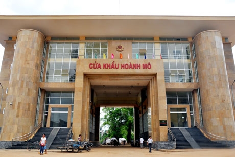
AsemconnectVietnam - Border gate economic zone of Hoanh Mo - Dong Van is a center of economic, culture, services, travel in north border region of Quang Ninh province.
GENERAL PLAN ON CONSTRUCTION OF BORDER GATE ECONOMIC ZONE OF HOANH MO-DONG VAN, QUANG NINH PROVINCE TO 2030
1. Boundary, area and duration of setting up general plan:
Including administrative boundaries of Hoanh Mo and Dong Van communes, Binh Lieu district, Quang Ninh province with a total area of about 14,236 ha.
- Bordering Fangcheng zone in the north, Fangcheng port city, Guangxi province, People's Republic of China;
- Bordering Hoc Dong commune. Binh Lieu district and Quang Son commune, Hai Ha district in the south
- Bordering Hoc Dong commune. Binh Lieu district and Quang Son commune, Hai Ha district in the south
- Bordering Quang Son commune, Hai Ha district in the east;
- Bordering Dong Tam commune, Binh Lieu district in the west.
Period of plan: the first phase to 2020 and long-term orientation to 2030.
2. Characteristics:
- Being a interdisciplinary economic zone, a center of economic, culture, services, travel in north border region of Quang Ninh province;
- Bordering Dong Tam commune, Binh Lieu district in the west.
Period of plan: the first phase to 2020 and long-term orientation to 2030.
2. Characteristics:
- Being a interdisciplinary economic zone, a center of economic, culture, services, travel in north border region of Quang Ninh province;
- Being a general urban area with modern architecture, special characteristic and ensuring criteria of urban grade V;
- Being a gateway of trade exchange, international trade hub and important traffic hub in northern mountainous region, Beibu gulf economic rim region; having favorable conditions for attracting and promoting investment activities on basis of synchronous technical and social infrastructure in border gate area.
3. Scale of plan:
3. Scale of plan:
- Total amount of population: about 7,020 people in 2015; 10,000 people in 2020 and about 14,000 people in 2030.
- Land fund: Total planed land area of 14,236 ha.
+ In a period to 2020: Land area for constructing functional zones of the economic zone is about 1,550 ha; other land area is about 12,685 ha.
+ In a period to 2030: Land area for constructing functional zones of the economic zone is about 1,920 ha; other land area is about 12,315 ha.
4. Development orientation of the zone:
- A long national road No.18 and key road of Hoanh Mo – Dong Van: developing urban areas and functional zones, forming concentrated construction area. Forming industrial trade area (non-tariff) along road of Hoanh Mo – Dong Van; constructing mixed trade and service areas associating with gate area of Hoanh Mo, central area of Hoanh Mo and border gate area of Dong Van.
- Area of low hills surrounding road of Hoanh Mo-Dong Tam, road of Dong Van – Khe Tien, low land area adjacent to the concentrated construction area, arranging production zones under model of farm and being standby area for development in long-term period.
- High mountainous area: being protective forest, it should be preserved, conserving natural landscape, creating sustainable ecological area. Steep untapped blank area, area surrounding protective forest will be controlled, limited construction in order create uninterrupted green tree system.
5. Functional areas:
5. Functional areas:
Hoanh Mo – Dong Van border gate economic zone is divided into three areas which are concentrated construction area; area of distracted construction, agro-forestry development and standby; area of natural landscape conservation and management.
5.1. Concentrated construction area:
- Border gate zone: area of approximately 33.3 hectares including Hoanh Mo border gate zone with an area of 20.3 ha; Dong Van border gate zone with an area of 13 ha. Arranging projects such as national gate, interdisciplinary control station, agencies of border gate management, parking, checkpoints;
- Administrative and management area of economic zones: building near current market of Hoanh Mo with a scale of about 1.8 ha;
- Trade and industry zone: scale of approximately 93.1 ha, locating alongside southern road of Hoanh Mo – Dong Van, being managed centrally under provisions of duty free area; have following functions: trade, warehouses, financial services, banking, transport, insurance, export commodity processing zones, trade promotion zones and other relevant function zones;
- Logistic zone: Total size of about 28 ha, being arranged in two areas next to border gate zone of Hoanh Mo and Dong Van border gate zone;
- Mixture zone of trade, services and border market: includes 3 clusters with a total area of 44.3 ha, associating with residential area in Hoanh Mo border gate urban area, central urban area of Hoanh Mo and Dong Van border gate urban area. Main function includes trading exchange office, general trading stores, restaurants, trade hub, goods distribution hub... Upgrading and expanding two existing border gate market in Hoanh Mo to market of type I and in Dong Van to market of type II;
- Urban areas: having infrastructure equivalent to urban area of grade V, including: urban public area of size of about 21.9 hectares; mixture area of trade and service with a size of about 7.1 ha; residential area of about 107.6 hectares with a total population amount of about 10,200 people in 2030.
Out of which: residential area of about 15.8 hectare in Hoanh Mo border gate urban zone with a total population amount of about 2,200 people; residential areas of about 43.3 ha in central urban area of Hoanh Mo with a total population amount of about 5,100 people; residential area in Dong Van border gate urban area with a size of 48.9 hectares and a total amount of population of about 2,900 people;
Out of which: residential area of about 15.8 hectare in Hoanh Mo border gate urban zone with a total population amount of about 2,200 people; residential areas of about 43.3 ha in central urban area of Hoanh Mo with a total population amount of about 5,100 people; residential area in Dong Van border gate urban area with a size of 48.9 hectares and a total amount of population of about 2,900 people;
- Trade and production zone: planning two trade and production clusters in Hoanh Mo border gate urban area with a size of 8.2 ha and Dong Van border gate urban area with a size is 8.2 ha; arranging facilities of products, goods production and processing for export and import;
- Tourism zone: forming ecological tourism zone of about 98 ha in mountain of Cao Ba Lanh; key functions of this tourism zone include historical studying tourism, sightseeing, resort, service of mountain climbing tourism...
5.2. Area of distracted construction, agro-forestry development and standby:
- Area of distracted construction: including resettlement areas and existing rural residential area with total size of about 147.5 hectares and a total amount of population of about 3,850 people in 2030. Out of which, Loong Vai residential area (Hoanh Mo commune) has a size of about 30.8 hectares and a total amount of population of about 790 people; residential area of Song Mooc (Dong Van commune) has a size of about 27.1 hectares and a total amount of population of about 1,070 people. Distracted residential zones have a total area of about 89.6 hectares and amount of population of about 1,990 people, maintaining existing structure of village and hamlet, limiting free migration. Other construction land area is 114.9 ha, including tourism zone in Dong Thang, land for external transport, rural transport, land for key technical infrastructure and land for national security and defense;
- Area of agriculture, forestry development and standby: maintaining 255.8 hectares of rice, 202.8 ha of other agricultural land to ensure food security, maintaining local production practices and local culture. Planning farm zone and development standby area mainly in Hoanh Mo commune, a part of Dong Van commune with a size of about 865.3 ha, developing towards commodity production. Production forest land fund has size of about 4,655.2 hectares being localized, organized to cultivate material trees and conserving local specialty forest garden fund;
- Remaining land area includes land of surface water, land for transport isolated green tree ground, land of stream bank with a size of about 409.6 ha.
5.3. Area of natural landscape conservation and management:
5.3. Area of natural landscape conservation and management:
Area of natural landscape conservation and management include border belt area and protective forest areas, unused area with high slope and high altitude next to protective forest area. Scale of the whole area is about 6,792 ha. Protective forest area will be conserved and embellished strictly, does not allow to construct civil works, encouraging activities of scientific research.
6. Organizing architectural space:
6.1. Space arrangement
6. Organizing architectural space:
6.1. Space arrangement
- Key spatial axis forming urban frame attaches to roads: national road No.18C to border gate; Hoanh Mo-Dong Van road; Dong Van – Khe Tien road, Luc Hon – Dong Tam – Hoanh Mo road; natural scenery associates with Tien Yen river, Dong Mo river and Dong Van stream;
- Scenic routes include strip of projects along east - west direction of industry and trade zone; agricultural and forest landscapes route in north - south direction in Long Vai and Song Mooc area and roads along rivers and streams under exploitation terrain of natural landscape space;
- Scenic routes include strip of projects along east - west direction of industry and trade zone; agricultural and forest landscapes route in north - south direction in Long Vai and Song Mooc area and roads along rivers and streams under exploitation terrain of natural landscape space;
- Space highlights include southwest gateway point on national road No.18C in direction from center of Binh Lieu, northeast gateway on provincial road No.341 in a direction from Bac Phong Sinh; sightseeing points to river of Dong Mo, river of Tien Yen, sightseeing point on mountain of Cao Ba Lanh, mountain of Bac Cuong;
- Key controlled area include border gate zone of Hoanh Mo, Dong Van border gate zone; landscape axis of trade and industry zone in Hoanh Mo; centers of border gate urban areas of Hoanh Mo, Dong Van;
- Newly constructed architecture projects have their own unique features such as: trade center, an interdisciplinary house, border gate head office, head office of industry and trade zone.
- Newly constructed architecture projects have their own unique features such as: trade center, an interdisciplinary house, border gate head office, head office of industry and trade zone.
6.2. Landscape preservation, embellishment and exploitation
- Urban areas: developing architecture projects having local characteristics, guaranteeing serving radius of social infrastructure. Limiting huge level of natural areas, respecting landscape;
- Residential zones outside urban areas: preserving structure of villages and hamlets, upgrading infrastructure, restoring cultural activities associating with traditional production space;
- Ecosystems: protecting natural environment, conserving biodiversity, expanding and renovating sections of rivers having narrow passage, planting and exploiting controlled forest to balance development .
7. Land using plan
- Ecosystems: protecting natural environment, conserving biodiversity, expanding and renovating sections of rivers having narrow passage, planting and exploiting controlled forest to balance development .
7. Land using plan
Total natural land area of economic zone is 14,236 ha, including:
- In a period to 2020: land area for constructing function areas of economic zone is about 1,550 ha, including:
- In a period to 2020: land area for constructing function areas of economic zone is about 1,550 ha, including:
+ Civil land area is approximately 244 ha, accounts for land area for construction of functional zones, out of which, land area of residential zones reaches 147 hectares or 147 m2/person;
+ Land area of non-residential zone is about 1,306 hectares, accounts for 84.23% of land area for construction of functional zones, including land area of trade and industry zone of approximately 52.3 ha;
+ Land area for other purposes is approximately 12,686 ha functions out of which area of agricultural land is approximately 486 ha, protective forest land area is around 5,560 hectares, land area of production forest and other functions is around 6,640 ha.
- In a period to 2030: land area for constructing function areas of economic zone is about 1,920 ha, including:
- In a period to 2030: land area for constructing function areas of economic zone is about 1,920 ha, including:
+ Civil land area is approximately 369 ha, accounting for 19.22% of land area for constructing function zone, including area of residential zone of 255 hectares or an average level of 135 m2/person;
+ Non civil land area is about 1,552 hectares, accounting for 80.78% of land area for construction of function zones, out of which, land area of trade and industry zone is approximately 93.1 ha;
+ Other fictional land area is approximately 12,316 ha, out of which, agricultural land area is approximately 458 ha, protective forest land area is around 5,560 hectares, land area of production forest and other features is approximately 6,298 ha.
8. Orientation of plan on technical infrastructure system:
8.1. Technical preparation
- Leveling:
+ For approved projects, continuing to implement under approved projects.
+ For newly constructed areas:
+ For approved projects, continuing to implement under approved projects.
+ For newly constructed areas:
. Hilly areas with slope <15%: designed and constructed under topography bench, building revetment walls to ensure stable foundation, not being eroded;
. Area of stream bank: leveling height must ensures minimum distant of 30 m from edge of water rising, minimum limited height are equal with the highest level of water rising +0.5 m;
. For public buildings, industrial production projects, height of limited foundation is higher than the highest water level from 0.7m -1m.
- Drainage:
. For public buildings, industrial production projects, height of limited foundation is higher than the highest water level from 0.7m -1m.
- Drainage:
+ Key drainage direction of entire area is to Dong Mo river, Tien Yen river.
+ Choosing drainage system: having separately rainwater drainage system and wastewater drainage system.
+ Streams are main drainage axis to river of Dong Mo. Sewers along roads mainly flows to streams, sewers next to rivers will drain directly into river of Dong Mo.
+ Rivera, stream passing through urban areas will be embanked to prevent erosion and create urban landscapes.
+ Streams are main drainage axis to river of Dong Mo. Sewers along roads mainly flows to streams, sewers next to rivers will drain directly into river of Dong Mo.
+ Rivera, stream passing through urban areas will be embanked to prevent erosion and create urban landscapes.
8.2. Transport:
- External transport:
+ National road No.18C: in a period of after 2030, continuing to upgrade and expand to reach road standard of grade II for allowed terrain sections.
- External transport:
+ National road No.18C: in a period of after 2030, continuing to upgrade and expand to reach road standard of grade II for allowed terrain sections.
+ Provincial road No.341: upgrading, renovating and extending section from Bac Phong Sinh border gate to Hoanh Mo border gate with mountainous road standard of grade IV.
+ Dong Van - Quang Ha road: upgrading to become provincial road to connect to Hai Ha, Ha Long – Mong Cai highway, national road No.18A, reaching mountainous road standard of grade IV.
+ Border corridor road: constructing completely border corridor road from Bac Luan - Bac Son - Quang Duc - Quang Son - Dong Tam – Vo Ngai to Lang Son, reaching road standard of grade V, after 2030, upgrading and extending to reach road standard of grade IV.
+ Border patrol road: for road section of Hoanh Mo - Lang Son, maintaining mountainous road standard of grade V.
- Transport of economic zone:
+ Urban transport:
. Main road connecting center of Hoanh Mo border gate zone with national road No.18C have width of 40.0 m;
- Transport of economic zone:
+ Urban transport:
. Main road connecting center of Hoanh Mo border gate zone with national road No.18C have width of 40.0 m;
. Key urban road of Hoanh Mo - Dong Van: upgrading existing road to have width of cross-section of 40.0 m;
. Road connecting functional zones have width of cross-section of 20.5 m - 26.0 m;
. Key road of areas: For newly constructed road: having width of 14.0 m - 18.0 m; for upgraded roads: having width of 11.5 m - 15.5 m.
. Road connecting functional zones have width of cross-section of 20.5 m - 26.0 m;
. Key road of areas: For newly constructed road: having width of 14.0 m - 18.0 m; for upgraded roads: having width of 11.5 m - 15.5 m.
+ Rural roads: upgrading roads to villages, hamlets to reach mountainous road standards of grade V, VI.
+ River crossing, traffic hub projects:
+ River crossing, traffic hub projects:
. Hoanh Mo bridge: having scale of 4 lanes in underground areas connecting border gate of Hoanh Mo and existing boder gate of Dong Trung;
. Hai Nac bridge: having scale of 2 lanes across river of Tien Yen;
. Hai Nac bridge: having scale of 2 lanes across river of Tien Yen;
. In long-term, researching to build bridges across river of Dong Mo to connect Dong Van with Fengchang area.
. Car park, station: newly building 2 car stations with scale of 3.7 ha in Hoanh Mo and 2.8 ha in Dong Van, out of which, combining truck station and bus station, minimum scale of bus station achieves grade 4.
8.3. Water supply:
. Car park, station: newly building 2 car stations with scale of 3.7 ha in Hoanh Mo and 2.8 ha in Dong Van, out of which, combining truck station and bus station, minimum scale of bus station achieves grade 4.
8.3. Water supply:
- Total water demand of economic zone to 2020 is about 3,000 m³/day, to 2030, approximately 4,200 m³/day.
Source of water:
+ Hoanh Mo concentrated border gate area, Hoanh Mo central urban area, Dong Van border gate area and trade, production cluster of Dong Van: Dong Mo stream, Dong Van stream and lake of Dong Van.
+ Distracted area: Source of stream water in each area.
Source of water:
+ Hoanh Mo concentrated border gate area, Hoanh Mo central urban area, Dong Van border gate area and trade, production cluster of Dong Van: Dong Mo stream, Dong Van stream and lake of Dong Van.
+ Distracted area: Source of stream water in each area.
- Key projects:
+ Water supply station No.1 with a capacity of 1,000 m³/day in 2030. Source of water: Dong Mo stream.
+ Water supply station No.2 with a capacity of 3,000 m³/day by 2020, by 2030, 4,500 m³/day. Water source: using Dong Van stream through newly constructed Dong Van lake.
+ Water supply station No.1 with a capacity of 1,000 m³/day in 2030. Source of water: Dong Mo stream.
+ Water supply station No.2 with a capacity of 3,000 m³/day by 2020, by 2030, 4,500 m³/day. Water source: using Dong Van stream through newly constructed Dong Van lake.
- Water supply network using pipe size of D100 mm - D300 mm, ring network.
- Plan of supplying water for distracted residential areas: using water of streams under new countryside water supply plan. Constructing water tank to supply water for households.
8.4. Power supply:
8.4. Power supply:
- Total electricity demand of the economic zone is approximately 20.3 MW by 2020; approximately 31 MW by 2030.
- Power source:
- Power source:
+ By 2020: using power from national grid through Tien Yen station of 110 kV. Building additionally circuit 2 of 35 kV line along provincial road No. 371.
+ By 2030: newly constructed 110 kV power station for Binh Lieu district, including additional charge of economic zone of Hoanh Mo- Dong Van with capacity (2x40) MVA.
- Electricity grid:
+ By 2030: newly constructed 110 kV power station for Binh Lieu district, including additional charge of economic zone of Hoanh Mo- Dong Van with capacity (2x40) MVA.
- Electricity grid:
+ To build newly circuit 2 of 35 kV line of Tien Yen - Binh Lieu – Hoanh Mo.
+ Existing medium voltage grid: in the first phase, shifting the line to pavement of key roads.
+ Long-term period: developing additionally 02 medium-voltage line to the economic zone.
8.5. Waste water drainage, solid waste management:
- Waste water drainage:
+ Existing medium voltage grid: in the first phase, shifting the line to pavement of key roads.
+ Long-term period: developing additionally 02 medium-voltage line to the economic zone.
8.5. Waste water drainage, solid waste management:
- Waste water drainage:
+ Total amount of waste water: living, public, trade and service wastewater will be collected and treated concentrated with a capacity of around 1,360-2,200 m³/day, separately treated a bout 120-230 m³/day; waste water of trade and production area will be treated with a capacity of about 472 m³/day.
+ Concentrated urban area: taking advantage of natural terrain, building maximum gravity sewers. Building centralized treatment station in Hoanh Mo border gate urban zone with a capacity of 2,200 m³/day and total land area of 0.5 ha.
+ Residential areas in Loong Vai, Song Mooc and hamlets: treating wastewater, cleaning naturally and reusing for agriculture; constructing biogas projects combining with waste, water waste treatment.
+ Industrial, trade and production wastewater: building a separate system of collecting and treating wastewater in Dong Van with a capacity of 146 m³/day; in Hoanh Mo with a capacity of 326 m³/day.
+ Industrial, trade and production wastewater: building a separate system of collecting and treating wastewater in Dong Van with a capacity of 146 m³/day; in Hoanh Mo with a capacity of 326 m³/day.
- Solid waste management:
+ Amount of waste: amount of living, public, trade and service solid waste is about 10 tons/day; amount of industrial, production and trade solid waste is about 5.3 tons/day.
+ To perform solid waste sorting at source of waste, separately collecting hazardous waste, inorganic waste. In the first stage, treating in common solid waste treatment zone of Binh Lieu district, in future, shifting to treatment zone of Dong Ngu in Tien Yen district which is built to serve entire region.
+ Organic waste is sorted at source, reusing a part, the rest is collected and treated in solid waste treatment zone with scale of 1 ha, locating newly in Hoanh Mo commune.
+ Inorganic wastes, hazardous waste will be treated in treatment zone of Dong Ngu in district of Tien Yen.
Long Giang
Source: moj.gov.vn
+ Inorganic wastes, hazardous waste will be treated in treatment zone of Dong Ngu in district of Tien Yen.
Long Giang
Source: moj.gov.vn
Scheme on attracting, restructuring and improving quality of labor resources in Binh Phuoc province in a period of 2021 - 2025, orientation to 2030
Plan on implementing national strategy on climate change for a period to 2050 in Quang Binh province
Plan on improving quality of human resources to 2025 and orientation to 2030
Program on conservation and development of Vietnamese craft villages in a period of 2021 - 2030
Implementation plan of marine aquaculture development project in Ninh Binh province to 2030 with a vision to 2045
Plan on implementing national environmental protection strategy to 2030 with a vision to 2050 in Kien Giang province
Plan on implementing Decision No. 327/QD-TTG dated March 10, 2022 of the Prime Minister approving the project on developing sustainable and effective wood processing industry in the period of 2021-2030 in Gia Lai province
Action plan on implementing strategy of sustainable agricultural and rural development in a period of 2022-2030 with a vision to 2050 in Hanoi city
Plan on implementing Decision No.923/QD-TTG dated August 2, 2022 of the Prime Minister approving science and technology program for new rural construction in a period of 2021-2025 in Vinh Long province
Plan on implementing strategy of sustainable agricultural and rural development in Bac Kan province in a period of 2021 - 2030 with a vision to 2050
Action plan on implementing livestock development strategy in a period of 2022-2030 with a vision to 2045 in Hanoi city
Implementation plan of Vietnam's forestry development strategy for a period of 2021-2030 with a vision to 2050 in Gia Lai province
National master plan in a period of 2021-2030, vision to 2050
Program on strengthening environmental protection, food safety and rural clean water supply in building new countryside in a period of 2021-2025
Plan on implementing Decision No. 327/QD-TTG dated March ...
Concretize viewpoints, objectives, tasks and solutions of the plan in accordance with practical conditions of the locality, associating ...Plan on implementing national environmental protection ...
Implementation plan of marine aquaculture development ...
Program on conservation and development of Vietnamese ...
Plan on improving quality of human resources to 2025 and ...

Efforts taken to turn culinary culture into national ...
The Vietnam Cuisine Culture Association (VCCA) is taking steps to implement a project to build and develop Vietnamese culinary culture ...Vietnamese cuisine making a name for itself with ...
Vietnam advance to next round of AFC U20 Women’s Asian Cup
Cultural tourism and traditional values promoted through ...
