


Mekong river delta plan in a period of 2021 - 2030 with a vision to 2050
Thursday, June 30,2022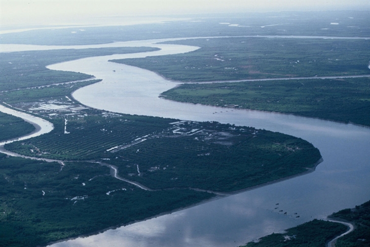
AsemconnectVietnam - Turning challenges into opportunities; transforming growth model in direction of increasing efficiency and value, focusing on effectively promoting human resources, science and technology, innovation, urbanism and industrial development
I. Scope and boundaries of plan
1. Land includes entire administrative boundary of Can Tho city and 12 provinces: Long An, Tien Giang, Ben Tre, Dong Thap, Vinh Long, Tra Vinh, Hau Giang, An Giang, Soc Trang, Kien Giang, Bac Lieu and Ca Mau.
2. Coastal waters of the provinces: Tien Giang, Ben Tre, Tra Vinh, Soc Trang, Bac Lieu, Ca Mau and Kien Giang.
II. Viewpoints, vision, development goals
1. Development viewpoints
a) Develop Mekong delta in direction of sustainable development and green growth in association with implementation of Resolution No. 120/NQ-CP dated November 17, 2017 of Government on sustainable development of Mekong river delta adapts to climate change; focus on protecting, embellishing and developing socio-cultural foundation and natural ecosystem; taking “people” as the center; consider water resources as the core; integrated management of water resources throughout basin to ensure maintenance of living resources for environment and people; changing livelihood models in sub-regions towards proactive adaptation to climate change.
b) Turning challenges into opportunities; transforming growth model in direction of increasing efficiency and value, focusing on effectively promoting human resources, science and technology, innovation, urbanism and industrial development.
c) Transforming development model from scattered, small to centralized; develop clusters of agricultural economic sectors associated with urbanized and industrialized areas to create breakthrough development.
d) Strengthening linkages between localities in the Mekong Delta; with Ho Chi Minh City and the Southeast region; expand trade with countries in ASEAN region, especially countries in greater Mekong sub-region.
Focus on developing infrastructure, which is important for transformation of development model, especially focusing on transport infrastructure, energy, clean water supply, irrigation and social infrastructure.
e) To closely combine socio-economic development with ensuring national defense and security, maintaining political stability and social order and safety; focus on ensuring food security, water sources, borders, sea areas and islands.
2. Vision
By 2050, the Mekong delta will become a region with a relatively high level of development compared to the whole country; a place worth living for people, an attractive destination for tourists and investors; prosperous and dynamic residential communities; important wetland ecosystems are preserved and developed; effectively exploit and promote natural resources and rich and diverse cultural identities for sustainable socio-economic development.
Urban system is properly distributed and developed sustainably. Transport system is developed synchronously, connecting within and between regions. Irrigation, information and communication infrastructure, electricity supply, water supply and drainage are built synchronously and modernly to meet requirements of agricultural production transformation, adapting to climate change and ensuring safety in face of climate change. System of cultural, educational - training, science and technology, health, physical training and sports facilities is quite developed compared to the whole country.
3. Development goals
a) Overall goal
To develop Mekong delta by 2030 to become a sustainable, dynamic and highly efficient agricultural economic center of the country, region and the world on basis of developing a system of focal centers for agricultural development, economic corridors and dynamic cities with diversified services and industries with synchronous infrastructure system, adapting to climate change; marine economic development; tourism economy; strengthening inter-regional, domestic and international connections; attach importance to development of science, technology and innovation; improve quality of human resources; create a sustainable living environment, good quality of life for people in association with conservation of natural resources and ecosystems; maintaining and embellishing unique and diverse cultural identities of ethnic groups; ensure political stability, national defense and security.
b) Specific goals
- Regarding environment and ecology:
+ Improve quality and increase forest cover rate to 7.5% by 2030, protect coral reef, mangrove, seagrass and lagoon ecosystems to ensure supply of important ecosystem services for socio-economic development and proactively prevent and minimize risks of natural disasters, climate change and sea level rise.
+ Reducing pollution in process of agricultural, industrial and urban development through modernizing wastewater and solid waste treatment technologies, increasing collection, treatment and recycling of waste. By 2030, 100% of ordinary solid waste and hazardous waste from urban and industrial areas will be collected and treated.
- Regarding culture - society:
+ Education - training: Raise level of education and invest in upgrading physical foundations of educational institutions; strive by 2030, to raise proportion of students at all levels and percentage of permanent classrooms to reach national average.
On labor:
Developing a high-quality and skilled workforce suitable to market needs, with focus on key regional industries. By 2030, rate of trained workers will reach 65%, of which degrees and certificates will reach 25%; proportion of workers in the non-agricultural sector (services and industry - construction) reached 75-80%; unemployment rate of working age workers in urban areas is less than 4%.
On medical:
To build a region-wide health system in direction of being comprehensive, modern and effective, meeting needs of protecting, caring for and improving the people's quality of life. By 2030, reach 30 hospital beds; 10 doctors; 2.8 university pharmacists; 25 nurses per 10,000 people.
About culture:
Constantly improving spiritual life of the people, gradually narrowing gap in cultural enjoyment between urban and rural areas. By 2030, strive for 100% of provincial administrative units to have all 3 types of cultural institutions. Preserve, embellish and develop cultural works, historical and revolutionary relics and culture of ethnic minorities in combination with tourism development.
- Regarding economic development:
+ Continue to promote strength of agricultural economy towards sustainability and application of high technology; maintaining proportion of added value at a high level of about 20-25% by 2030; make effective use of free trade agreements to expand the market.
+ Transforming economic structure towards industrialization and modernization; gradually shift from labor-intensive to capital-intensive industry structure, from low to medium and high technology towards intelligence. By 2030, proportion of labor-intensive industries, raw processing and low-tech industries will be reduced to less than 50%; proportion of capital-intensive industries, medium and high-tech industries such as chemicals, textiles, machinery and equipment, electrical appliances and means of transport account for over 40% of production value of manufacturing industry.
+ Economic growth at an average rate of about 6.5%/year. Size of economy (GRDP) in 2030 is 2-2.5 times larger than in 2021.
+ Economic structure: By 2030, proportion of agriculture, forestry and fishery in the GRDP will be about 20%; industry - construction about 32%; services about 46%; taxes and subsidies are about 2%.
- Regarding infrastructure development:
+ To develop a system of multi-modal transport systems connecting inter-regional and international with emphasis on promoting the region's strengths in inland waterway navigation. By 2030, invest in building and upgrading about 830 km of expressways; about 4,000 km of national highways; 04 airports; 13 seaports, 11 clusters of passenger ports and 13 clusters of inland waterway cargo ports.
+ Developing energy infrastructure, focusing on renewable energy development, ensuring proactive energy balance for the region's development needs.
+ Irrigation infrastructure is built synchronously in accordance with transformation of agricultural production to adapt to climate change in ecological sub-regions, while ensuring proactive flood control and response to extreme floods, landslide prevention.
+ Improve quality of water supply services, ensure safe water supply; step by step modernize clean water management, production and trading system. By 2030, percentage of urban population using clean water will reach 98 - 100%; percentage of rural population using clean water from centralized water supply system reaches 70%.
- Regarding national defense and security:
Invest in completing border traffic system, increasing traffic connection from international border gate system to intra-regional and inter-regional development centers, infrastructure associated with border and island protection; ensure a close combination between socio-economic development and defense and security consolidation.
III. Advantageous industry development direction
1. Agricultural development direction
a) Transforming agricultural production structure to adapt to changes in natural conditions according to three ecological sub-regions:
- Freshwater ecological zone in upstream and central part of the delta (including the provinces of An Giang, Dong Thap, Hau Giang, Vinh Long, Can Tho city and part of provinces of Kien Giang, Soc Trang, Tra Vinh, Ben Tre, Tien Giang, Long An); is a freshwater ecological area safe from impact of floods, inundation and saltwater intrusion; is a key area for production of rice, freshwater aquatic products and fruits of the Mekong Delta and the country; develop a diversified, modern and sustainable agriculture, taking into account adaptation to extreme floods and play a role in regulating and absorbing floods for the Mekong Delta.
- Coastal saline - brackish ecological zones (including part of the territory of the provinces of Kien Giang, Ca Mau, Bac Lieu, Soc Trang, Tra Vinh, Ben Tre, Tien Giang and Long An): To develop aquaculture saltwater, saline - brackish water products on the shore and in the sea; fishing; restore and develop coastal mangrove forests in association with biodiversity protection and coastal strip; develop agro-forestry system in direction of ecology, organic, combined with eco-tourism; proactively prevent, avoid and minimize risks of natural disasters, climate change and sea level rise.
- Freshwater - brackish transition zone in middle of the delta (including part of the territory of provinces of Kien Giang, Ca Mau, Bac Lieu, Soc Trang, Tra Vinh, Ben Tre, Tien Giang, and Long An): Developing marine navigation specialized brackish water production and rotation with rice and vegetables suitable to seasonal water conditions.
b) Developing strategic products under three focus areas: Fisheries, fruits and rice in the direction of increasing proportion of fishery and fruits and reducing proportion of rice.
c) Developing high-quality commodity agriculture, combined with trade, logistics services, eco-tourism, industry, focusing on the processing industry, improving value and competitiveness of agricultural products Karma.
d) Develop a system of agricultural focal centers associated with specialized farming areas, connecting with urban centers that act as regional and sub-regional centers and national and inter-regional infrastructure hubs; is a place providing logistics services, research and development, training and technology transfer, collection, deep processing, high technology application to improve value and competitiveness of agricultural products, specifically:
- General focal center in Can Tho city with main functions of trade, logistics, research and development, training and technology transfer, deep processing industry, high technology application to increase prices value for agricultural products, especially rice and aquatic products; develop logistics services in Hau Giang province to support Can Tho city in fulfilling its role as the logistics center of the Mekong Delta.
- Focal point in An Giang, Dong Thap associated with raw materials for freshwater aquatic products, fruits and rice in freshwater ecological zones.
- Focal point in Kien Giang, Ca Mau, Soc Trang associated with raw material areas for aquatic products in coastal areas.
- Focal point in Tien Giang, Ben Tre associated with main raw material areas of fruits and vegetables.
To develop agriculture in Mekong delta in association with new rural development program and process of urbanization in sub-regions in order to effectively coordinate and exploit resources; strengthen urban-rural linkages in research, training, technology transfer in agricultural production and promote trade, logistics services and market connectivity of agricultural products.
e) Promote concentration and accumulation of land to form concentrated production areas, large-scale material areas with high competitiveness and efficiency, especially high-tech applied agriculture, organic agriculture.
g) Promote research and application of science and technology in fields of: seed, feed and processing; strengthen sustainable farming, protect environment and ensure food safety.
2. Industrial development direction
a) Develop industry in a sustainable and environmentally friendly manner, focusing on developing processing industry and supporting industries in order to raise value and competitiveness of agricultural products; make in-depth, export-oriented investment in groups of agro-forestry-fishery processing industries associated with raw materials, chemical and mechanical products for agriculture.
b) Improve concentration and density of industrial parks and industrial clusters on basis of linking with urban areas, regional, inter-regional and international linked infrastructure systems to improve efficiency and competitiveness.
c) Developing high-tech and information technology application industry; exploit potential of developing clean energy and renewable energy in association with forest and coastal protection.
d) Development orientation of main industries
- Processing industry:
+ Food processing: To encourage development of food processing factories for aquatic products, fruits and rice, applying advanced and modern technologies at focal centers and convenient areas for raw materials to create high quality products, economic value for export; invest in building a system of cold storage to support collection, transshipment and transportation of agricultural products at focal centers.
+ Processing animal and aquaculture feeds: To develop a network of livestock and aquaculture feed processing establishments in association with focal centers and concentrated production areas; to build a number of fishmeal processing factories with advanced technology and equipment in order to reduce amount of fishmeal imports and feed costs and encourage all economic sectors to gradually build large-scale and high-quality factories, high product volume; invest in frozen storage with a capacity of 10,000 tons/year.
+ Slaughtering and meat processing: Rearranging system of slaughterhouses in direction of limiting and gradually eliminating manual slaughterhouses, dispersed in households and building collective slaughterhouses and far away from residential areas equipped with quarantine and environmental treatment systems; encourage and support enterprises to develop on-site frozen slaughter and processing facilities. Build a canned food processing factory with medium scale, modern equipment and advanced technology to meet export demand, located in industrial park.
+ Producing wooden products and handicrafts: To focus on developing factories producing household furniture, factories producing artificial boards and plywood; Encourage development of production of traditional handicraft products such as wooden handicrafts, rattan, bamboo, leaves, sedge mats... to serve tourism needs in localities such as Ben Tre, Kien Giang and Tien Giang, Hau Giang.
- Power industry: By 2030, no more coal-fired thermal power will be developed other than coal-fired power plants under construction in Duyen Hai II (Tra Vinh), Long Phu I (Soc Trang), Song Hau I (Tra Vinh), Long Phu I (Soc Trang) and Song Hau I (Hau Giang); focus on developing wind power in Ca Mau peninsula and solar power; building power plants capable of flexibly adjusting and storing battery sources to ensure stable operation of the power system with a high proportion of renewable energy sources; consider developing gas power projects in Bac Lieu, Kien Giang and Long An after 2030.
- Mechanical industry, electrical and electronic equipment: To develop mechanical industry into value-added stages such as designing, manufacturing molds, manufacturing complex components with high precision; implementing projects on rolling mills, steel rolling and aluminum profiles, mechanical projects serving oil and gas industry; civil and auxiliary electronic equipment factory; factories producing agricultural machines, agricultural, forestry and fishery processing machines and equipment; center for testing electromechanical and electronic equipment; medical equipment and instruments factory; develop shipbuilding and repair industry, small and medium-sized watercraft in Tien Giang, Vinh Long, Kien Giang and Can Tho. Prioritize investment in projects with high technology and production level, using modern technology to meet requirements of cleaner production, saving energy and improving product quality.
- Chemical industry and chemical products: To develop chemical industry and chemical products selectively to reduce environmental pollution, promote technological innovation and improve product quality; invest in development of pharmaceutical and chemical products to meet demand for medicinal drugs; diversify products, improve quality and design to compete with domestic and foreign markets; encouraging development of fertilizer factories in Ca Mau; invest in improving quality, lowering costs, diversifying specialized fertilizers with high nutritional content, less environmental pollution, less washed out...; research and invest in production of microbial organic fertilizers processed from locally available sources of civil waste and peat.
- Building material production industry: To develop production of new, energy-saving, green and clean materials in line with planning for exploitation, processing and use of minerals as construction materials nationwide. Organize and rearrange sand mining facilities to ensure that they do not increase risk of riverbank and coastal erosion, protect natural resources and protect traffic and irrigation works on river and coastal routes. .
3. Service development direction
a) About trade
- Investing in synchronous construction of a system of commercial infrastructure from trade-service zone, logistics center to the people's market system to effectively support focal centers of agriculture; attach importance to building a system of storage and preservation of agricultural products to meet standards; develop e-commerce and border trade to expand commodity consumption market and promote export of agricultural products with strengths.
- Strengthening linkages and cooperation between localities, cooperatives, associations and businesses to build and consolidate some key brand identities of agricultural products in Mekong Delta for domestic and international markets.
b) About tourism
- To develop Mekong delta into an international brand for agro-rural tourism, eco-tourism (land gardens, wetlands) and marine tourism on the basis of product development and general promotion for the brand; develop Can Tho and Phu Quoc into two international tourism centers, a gateway to welcome guests of the whole region.
- To develop national and regional tourism sites and attractions in association with protection of natural ecosystems and preservation of cultural - historical values, including: Phu Quoc, Nam Can national tourism sites - cape of Ca Mau, Tram Chim - Lang Sen, Sam Mountain, Thoi Son; national tourism attractions: Ong Ho island, Cao Van Lau memorial area, Ninh Kieu wharf, Ba Om pond, Ha Tien, Van Thanh Mieu...
- Develop tourist routes connecting within the region, inter-region, national and international, focusing on developing inter-regional tourist routes associated with Ho Chi Minh city, Can Tho city, Phu Quoc, Ca Mau; southern coastal corridor (Thailand - Cambodia - Rach Gia - Ca Mau) and international road border gate system of Ha Tien (Kien Giang), Tinh Bien (An Giang), Dinh Ba, Thuong Phuoc (Dong Thap) and Binh Hiep (Long An); sea routes and river routes along Tien and Hau rivers connect with Phnom Penh, Seam Reap (Cambodia).
c) Urban areas that are general and specialized centers of regions and sub-regions include:
- Can Tho city is a grade I urban center directly under central government, a center of administration, services, commerce, healthcare, education - training, science - technology, culture, tourism and industry, processing of the whole region; providing high-quality health and education services that are competitive at the national, regional and international levels.
- My Tho city plays role of one of the centers of trade, logistics and tourism services in northern region of Tien river; urban gateway between Ho Chi Minh City and Mekong delta; high-tech agricultural center for fruit trees and garden tourism service center.
- Tan An city plays role of an industrial, commercial and service center in northeast of the Mekong Delta, a gateway urban between Ho Chi Minh City and Mekong delta.
- Long Xuyen city plays the role of one of trade and service centers in northwest of Mekong delta; is a center for technology transfer in hi-tech agriculture, especially rice and freshwater fisheries.
- Rach Gia city plays role of a center of marine economy, trade and service in western coastal area of Mekong Delta; is a center for aquaculture, fishing and export of aquatic products; agro-fishery processing industry center.
- Ca Mau city plays role of center of coastal sub-region in Ca Mau peninsula area; is national center of energy and petroleum services, center of ecotourism services, center of seafood processing in the region.
- Soc Trang city plays role of economic center of the East Coast sub-region; is a center for aquaculture, fishing and export of aquatic products; agro-fishery processing industry center, clean energy industry; historical and cultural tourism center.
d) To build and develop a sustainable island city in harmony between economic development and preservation of historical and cultural relics, biodiversity conservation of sea and islands and assurance of national defense and security; gradually build and perfect infrastructure, towards formation of international marine tourism and service centers in Phu Quoc.
2. Direction of rural system development
a) To distribute and develop a network of rural residential areas on basis of forming agro-industrial townships associated with focal centers and agricultural-rural tourism.
b) Develop form of rural residential space according to the characteristics of each sub-region; preserve and promote landscape architectural space and cultural identity of the river; increase population density for better access to technical and social infrastructure.
c) Control and limit construction of concentrated residential areas in areas close to riverbanks, canals and canals with high risk of landslides; arrange and rearrange population along rivers, canals and canals in association with new rural construction.
d) To plan and invest in building clusters of residential lines and houses in frequently flooded areas, suitable to people's cultural customs and production conditions; reserve space for flood drainage to ensure the safety of people's lives and properties.
Focus on upgrading essential infrastructure to ensure stability of people's lives, especially traffic, electricity supply, water supply, information and communication, health care, and education.
e) Preserve and develop traditional craft villages, cultural villages and ethnic minority communities in combination with tourism development.
3. Direction of development of functional areas
a) Economic zones, industrial zones
- In period up to 2030, continue to develop economic zones in region associated with key urban areas in sub-regions, including: Phu Quoc (Phu Quoc economic zone), Duyen Hai (Dinh An economic zone), Nam Can (Nam Can economic zone), Tan Chau, Tinh Bien (An Giang border gate economic zone), Ha Tien (Ha Tien border gate economic zone), Hong Ngu (Dong Thap border gate economic zone) and Kien Tuong (Long An border-gate economic zone).
- Renovate, upgrade and renew existing industrial parks; encourage new establishment and expansion of industrial parks and economic zones within development corridors and dynamic development zones. Priority is given to development of economic zones and industrial zones in urban-industrial corridor from Can Tho to Long An, connecting with Ho Chi Minh City and central quadrangle area.
Based on investment needs, regulations on conditions for establishment and expansion of economic zones and industrial zones and plan of Mekong delta region, the People's Committees of the provinces and centrally run cities shall determine method of planning for establishment and expansion of economic zones and industrial zones, projects on development of economic zones and industrial zones in the provincial plan.
b) Tourism area
To develop national and regional tourism sites and attractions in association with protection of natural ecosystems (hills, forests, rivers, lakes, etc.): Phu Quoc national tourist area, Nam Can - Ca Mau Cape, Tram Chim - Lang Sen, Sam mountain, Thoi Son; National tourism attractions: Ong Ho island, Cao Van Lau memorial area, Ninh Kieu wharf, Ba Om pond, Ha Tien, Van Thanh Mieu...
c) Concentrated production areas
- Freshwater ecological zone: To develop a rice-growing area, combining livelihoods based on flood season and freshwater aquaculture.
- Transition zone between fresh and brackish: To develop areas for specialized cultivation of fruit trees and vegetables, combining with seasonal salt and brackish aquaculture.
- Salty - brackish coastal areas: To develop areas specialized in aquaculture in a sustainable way.
VI. Direction of infrastructure development
1. Traffic network
a) By road
- Expressway system: expressway system by 2030, with a vision to 2050 has a total length of about 1,166 km, including three vertical axes connecting provinces and cities in region with southeast region and three horizontal axes in order to strengthen connection with seaport system in region with international border gates:
+ Longitudinal axes: North-South expressway to east (section of Ho Chi Minh city - Can Tho - Ca Mau), about 245 km long, with 4-6 lanes; north - south expressway to the West (Duc Hoa - Rach Soi section) is about 180 km long, with a size of 6 lanes; expressway route Ho Chi Minh City - Tien Giang - Ben Tre - Tra Vinh - Soc Trang is about 150 km long with 04 lanes.
+ Horizontal axes: Chau Doc - Can Tho - Soc Trang expressway is about 191 km long with 6 lanes; Ha Tien (Kien Giang) - Rach Gia - Bac Lieu expressway is about 212 km long with 4 lanes; Hong Ngu (Dong Thap) - Tra Vinh expressway is about 188 km long with 4 lanes.
- Highway system:
+ To focus on upgrading and renovating main national highway system, especially giving priority to a number of national highways connecting with localities where no expressways are available, including: national highway N1; national highway No.1, national highway No.50; highway No.60; national highway No.61C; national highway No.62; national highway No.30; national highway No.80; national highway No.91; national highway No.63; road south of Hau river; Quan Lo street with an estimated total length of about 1,815 km; scale according to plan (class/lane IV-II, 2 - 6 lanes); maintaining stable operation of minor national highways with a total length of about 2,351 km (classes/lanes IV-III, 2-4 lanes).
+ Reviewing to invest in and renovate bridges on existing main and secondary national highways that are limited in capacity, not stable in order to improve transport efficiency throughout network in the region; step by step modernize management and maintenance system of the works, improve efficiency of exploitation throughout network.
- Coastal roads: system of coastal roads is built by locality to ensure compliance with road network plan for a period of 2021 - 2030, with a vision to 2050; Route is expected to pass through Tien Giang, Ben Tre, Tra Vinh, Soc Trang, Bac Lieu, Ca Mau and Kien Giang provinces with a total length of about 788 km.
- Inter-provincial roads: Develop a number of axes connecting to major transport hubs, industrial parks, promote trade exchange, investment and development among provinces in the region, including:
+ Route Khanh Binh - Cho Moi (An Giang) - Lap Vo (Dong Thap), about 85km long.
+ An Giang - Kien Giang - Hau Giang route from national highway N1 to national highway No.61C about 130km long.
+ Tien Giang - Long An route - connects to national highway No.50 to Ho Chi Minh City about 30 km long.
+ Route of Sa Dec (Dong Thap) - O Mon (Can Tho) - Giong Rieng (Kien Giang), about 77km long.
- During planning, design and construction of road traffic routes, it is necessary to calculate and arrange sluices and dams to meet requirements for flood drainage, natural disaster prevention and control; study plan to combine route section of national highway and coastal road with system of dykes and sluices to control salt and fresh water in the process of provincial planning to ensure conformity with direction of agricultural development in the sub-regions.
b) Regarding inland waterways
- Transport corridor: To focus on investment and development of inland waterway infrastructure in order to bring into full play the potentials and advantages of region; increase market share of container transport, in which focusing on connecting the regional focal centers through the main waterway transport corridor is Ho Chi Minh City - Can Tho - Ca Mau (transport volume is about 99 105). million tons); Ho Chi Minh City - An Giang - Kien Giang (transport volume is about 55.2 ÷ 58.5 million tons); waterway corridor connecting with Cambodia through Tien and Hau rivers (transport volume is about 12.7 15.3 million tons) and coastal waterway corridor from Quang Ninh to Kien Giang (transport volume is about 12.7 15.3 million tons), about 62.5 ÷ 70 million tons); technical level of main inland waterway routes on transport corridors in the region is planned to reach grade IV or higher by 2030.
- Inland waterway infrastructure system: To develop 13 clusters of cargo ports to ensure the total throughput of cargo capacity is estimated at over 53 million tons/year; 11 clusters of passenger ports ensure total throughput capacity is estimated at 31 million passengers/year. The system of special-use ports is developed according to the needs of transport to serve directly and in accordance with plan of economic zones, industrial parks, production plants, new construction and repair of vehicles, processing of agricultural, forestry and aquatic products.
- For development of inland waterways under local management: To arrange and develop inland waterway ports and wharves on local waterways and passenger ports, specialized ports and inland wharves on waterways national plan in the provincial plan is consistent with spatial organization and functional zoning, ensuring consistency and synchronism, consistent with the planning of port clusters.
c) About maritime
- Seaport system by 2030 will meet demand for goods through 64 to 80 million tons (container cargo from 0.6 to 0.8 million TEU); passengers from 6.1 to 6.2 million passengers; by 2050 to meet demand through goods with an average growth rate of about 5.5 to 6.1%; average passenger growth is between 1.1 and 1.25%.
- Class I seaports include: Can Tho, Tra Vinh and Long An seaports. Class II seaports include: Dong Thap and Hau Giang seaports. Class III seaports include: Vinh Long, Tien Giang, Ben Tre, Soc Trang, An Giang, Kien Giang, Bac Lieu and Ca Mau seaports. Tran De wharf area (Soc Trang seaport) orients potential plan to become a special seaport, taking on role of a gateway port in Mekong delta. Hon Khoai Wharf (on Hon Khoai Island) is oriented to become a general port with potential development conditions, depending on needs and capacity of investors.
- Upgrading, renovating and maintaining navigational channels in region to ensure stable operation and suitability with exploitation capacity of seaport system, in which focusing on renovating and upgrading main channels including avigational channels for large tonnage ships entering Hau River and Tran De navigational channels.
d) About railway
Railway network in Mekong Delta in a period up to 2030, with a vision to 2050, includes 01 railway from Ho Chi Minh City - Can Tho with a length of about 174 km and a gauge of 1,435 mm.
d) About aviation
- Phu Quoc International Airport plays role of an airport serving international and domestic tourists. Can Tho International Airport is focal center for development of air logistics in the region, Rach Gia and Ca Mau airports, in addition to being domestic airports, also act as training and coaching centers.
- Scale of airports by 2030 is as follows:
+ Can Tho International Airport: Level 4E, capacity of 7.0 million passengers/year.
+ Phu Quoc international airport: level 4E, capacity of 10 million passengers/year.
+ Rach Gia airport: grade 4C, capacity 0.5 million passengers/year.
+ Ca Mau airport: grade 4C, capacity of 1 million passengers/year.
- Research and develop a network of specialized airports to serve needs of personal flight, tourism and rescue in a number of potential areas such as Phu Quoc, Chau Doc, Ha Tien, Nam Can, My Tho, Dong Thap, Tran De...
e) Multimodal transport connection
- Focus on solving bottlenecks and congestion points on national inland waterways; speed up implementation of container port construction projects in key development areas; invest in a system of loading and unloading equipment at inland waterway ports with role of satellite berths, cargo collection for seaports.
- Connecting roads with seaports: Prioritizing investment in road sections behind port to ensure technical synchronization, convenient connection with national traffic network.
2. Power supply system
a) Develop power sources and power grids in accordance with electricity development master plan for a period of 2021 - 2030 with a vision to 2045 and national master plan on energy for a period of 2021 - 2030 with a vision to 2050.
b) About power source
Prioritize rational development of electricity from renewable energy, ensuring highest overall economic efficiency of national power system; develop thermal power plants at an appropriate rate, consistent with supply and distribution capacity of raw materials, in association with implementation of Vietnam's commitments at COP26.
c) About power grid
- Build and upgrade power grid, step by step meet the technical standards of the transmission grid and be able to distribute it throughout territory of Mekong Delta. Important grid projects include:
+ Construction of 500 kV transmission lines: Tay Ninh - Dong Thap - Thot Not, Thot Not - Bac Lieu, Duyen Hai - My Tho - Duc Hoa, Long Phu - O Mon.
+ Connecting 220 kV lines: Dong Thap - Hong Ngu - Chau Doc; Dong Thap - Cho Moi - Chau Thanh - Hon Dat.
- Linking power grid with countries in Mekong Sub-region: promoting cooperation, exchanging electricity, ensuring benefits and safety of power system; maintain and strengthen grid connection with Cambodia through existing 220 kV transmission line and based on bilateral and multilateral cooperation programs.
3. Irrigation network
a) Develop irrigation systems, change operating regulations in line with orientation of transforming agricultural production in sub-ecologies in direction of proactively living with floods, salinity intrusion and adapting to climate change; climate and sea level rise.
b) Ensure adequate supply for domestic and industrial water supply needs. To study and build water supply routes from fresh areas in middle of the delta for Ca Mau peninsula and coastal provinces to serve daily life and production in dry season.
c) Promoting traditional solutions, proactively storing water, balancing water in place to serve daily life and essential production; dispersed water reservoir; water saving solutions; dredging main canals, grade I and grade II canals to increase circulation and exchange of water and enhance irrigation capacity and increase water storage capacity for the dry season.
d) Developing a system of dikes and embankments to protect residential areas, production areas and works of important political, socio-economic significance in face of impacts of land subsidence, sea level rise and danger. In a period to 2030, focuses on solutions to upgrade and complete system of level I dykes including sea dykes and dikes along main rivers to protect key areas of the region. Level II dike system protects irrigation systems and grade III dike protects small-scale inner-field plots developed within each locality according to actual development needs in order to ensure flood prevention and control river floods and tides for important agricultural production areas, urban areas, rural residential areas, industrial parks and key infrastructures.
For annual flooded areas such as Long Xuyen Quadrangle, Dong Thap Muoi and the area between two rivers: Operate irrigation systems and dikes in direction of accumulating water into fields to absorb floods and serve seasonal livelihoods; build culverts under the dike and pumping stations if necessary to actively supply and drain water; protect flood escape space; strengthening dike system, dredging main canals in order to improve flood drainage axes to the West Sea and Vam Co river.
e) Building a system of sluices and dikes along Tien river from Chau Thanh district to Cai Be district, Tien Giang province, along Hau river, Co Chien river and north of Mang Thit river in Vinh Long province to control salinity - freshwater, protect orchards in years of deep salinity intrusion.
g) For transitional area in south of Cai Lon river to study and build a system of sluices and dikes on south bank of Cai Lon river to control saline intrusion; develop operation process of Cai Lon - Cai Be sluice system and sluices along the west and south banks of Cai Lon river in order to actively supply fresh and brackish water to the region.
h) For Quan Lo Phung Hiep area, it is necessary to build a system of sluices and dikes along Hau River to control salinity and enhance ability to transfer water from Hau River to Ca Mau Peninsula to reduce pollution and supply brackish water for dilution for aquaculture in the dry season; build small pumping stations for irrigation and drainage.
i) For Nam Mang Thit irrigation system, build a system of culverts and dikes along south bank of Mang Thit River in order to close system, proactively control saline - freshwater, increase self-flow irrigation and reduce pollution.
k) For Ben Tre province, build dikes and sluices along Tien, Ham Luong and Co Chien rivers in order to close irrigation system in north Ben Tre and south Ben Tre to proactively control saltwater - freshwater, increase capacity self-flow irrigation, reducing pollution.
l) For coastal areas, complete the system of irrigation works to proactively supply water, control salinity, build separate water supply and drainage channels, or conduct water circulation in service of production and farming, aquaculture; continue to invest in building, strengthening and upgrading sea dykes, breakwater systems causing accretion in combination with afforestation to protect sea dykes and coasts; control groundwater exploitation to limit subsidence.
m) Preventing riverbank and coastal erosion; build breakwaters to limit coastal erosion in key areas.
n) Building a specialized early warning and forecasting system on floods, droughts and salinity, including building new and upgrading meteorological - hydrological and salinity measurement stations in real time for the whole region.
4. Water supply network
a) Water supply zoning
- On basis of topographical conditions, water sources, current situation and regional spatial development orientation, water use demand and development of water supply in stages of development into 02 water supply regions:
+ Northeast region of Hau river includes provinces of Long An, Tien Giang, Ben Tre, Tra Vinh, Vinh Long and Dong Thap.
+ Southwest region of Hau river: Including all provinces/cities of Can Tho, An Giang, Kien Giang, Hau Giang, Soc Trang, Bac Lieu, Ca Mau.
- In water supply areas, according to water source conditions, they are divided into areas: Advantages, disadvantages and difficulties in terms of water sources as a basis for selecting appropriate water supply solutions:
+ Areas favorable for water sources include the following provinces: Dong Thap, An Giang; part of Can Tho city.
+ Areas with less favorable water resources include the following provinces: Long An, Tien Giang; part of Vinh Long province and Can Tho city.
+ Areas with difficulties in water resources include the provinces of Ben Tre, Hau Giang, Soc Trang, Bac Lieu, Ca Mau, Kien Giang and Tra Vinh; part of Vinh Long province.
b) Water source
- Exploiting and using water sources in accordance with functional zoning of water sources and prioritizing allocation in normal cases in cases of drought or water shortage.
- Main water source for domestic and production needs is surface water from the Tien and Hau river systems. In context of responding to climate change and saltwater intrusion, apply solutions to exploit and transmit raw or clean water sources to ensure water demand, water quality, economic and technical efficiency as prescribed and meet sustainability requirements.
- Control and limit use of underground water sources in coastal areas and areas with severe land subsidence; research solutions to replenish water sources for underground water sources and research and evaluate deep aquifers as reserves.
- Reviewing and exploiting local land fund conditions, building rainwater storage reservoirs, supplementing water supply sources for existing water plants, especially in coastal areas and areas heavily affected by alum.
c) Water plants, raw water pumping stations of inter-provincial scale
- Inter-provincial-scale water plants: Invest in building 05 water plants with inter-provincial scale and connect to inter-provincial transmission pipeline network to supply water to areas with saline intrusion or difficult water sources about water resources. Capacity scale, location of water exploitation and water supply scope of inter-provincial-scale water plants are expanded based on water use demand, climate change scenarios, saline intrusion in each area. Priority projects include:
+ Song Tien 1 water plant (Tien Giang): with a capacity of about 200,000 - 300,000 m3/day; Tien river water source and other additional water sources suitable to climate change conditions; water supply scope: Tien Giang province and part of Long An province.
+ Tien River Water Plant 2 (Vinh Long): With a capacity of about 200,000 - 300,000 m3/day and night; Tien river water source and other additional water sources suitable to climate change conditions; water supply scope: Vinh Long, Tra Vinh, Ben Tre provinces.
+ Hau river water plant cluster 1 (Can Tho, Hau Giang): with a capacity of about 400,000 - 600,000 m3/day; water source of Can Tho river, Xa No canal, Hau river; water supply scope: Hau Giang, Soc Trang, Bac Lieu, Ca Mau and a part of Can Tho city.
+ Hau river 2 water plant (An Giang): with a capacity of about 200,000 - 300,000 m3/day; water source of Hau river; scope of water supply: Part of An Giang, Kien Giang and Can Tho city.
+ Hau river 3 water plant (An Giang): with a capacity of about 100,000 - 150,000 m3/day; water source of Hau river; scope of water supply: Part of An Giang and Kien Giang provinces.
- Raw water pumping stations of inter-provincial scale: To encourage investment in building raw water pumping stations for areas with difficulties in water sources and areas with less convenient water sources to ensure meeting domestic water use demand.
d) Water treatment technology
- Applied clean water treatment technology must be suitable to scale of water plant's capacity, composition and nature of the raw water source; quality of treated water must meet the standards of drinking and daily-life water quality.
- For water plants of inter-provincial scale, large capacity, using advanced and modern water treatment technology, adapting to climate change and being environmentally friendly; for small-scale water plants, applying traditional water treatment technology, gradually improving in accordance with management and operation capacity of the water supply unit.
- Researching and applying brackish and salt water treatment technologies to supply water to islands and residential areas with saline water sources or unable to connect to inter-provincial water plants.
Water supply pipe network
Network of inter-provincial transmission pipelines leading clean water or raw water from inter-provincial-scale water plants to localities will be connected into a ring network by 2030 and ensure safe water supply. At the connection points between the inter-provincial transmission pipeline and the local water distribution pipeline, pumping stations and water tanks are arranged to store and stabilize water sources.
e) Booster pump station
Arrange booster pumping stations on inter-provincial transmission pipelines, ensuring the transmission of water with sufficient flow to connection points with distribution pipelines supplying water to the locality; location, scale and capacity of the booster pumping station are specified in the investment project formulation phase.
g) Localities in Mekong Delta shall plan and invest in expanding the water supply road network and connect and use water sources from the inter-provincial regional water supply network when implementing the provincial plan.
- For areas with favorable water sources: Continue to use water sources from existing water plants; invest in expansion or construction of new water plants according to the provincial planning and local construction planning.
- For areas with less favorable water sources: To renovate and upgrade existing water plants; invest in building raw water pumping stations. For the increased demand for water supply development in each planning period, invest in expanding the water supply pipeline network and connecting and using water from inter-provincial-scale water plants. Rural residential areas have not been connected to inter-provincial-scale water plants, are exploiting underground water sources, and need to control the quality and reserve of underground water sources to meet sustainable requirements.
- For areas with difficulty in water resources: Invest in expanding the water supply pipeline network and connecting and using water from inter-provincial-scale water plants; for a number of small urban centers and rural residential areas that have not yet been connected to inter-provincial-scale water plants, renovate existing water plants or build new applications of brackish and salt water treatment technologies suitable fit.
- For island districts: Investing in reservoirs and dams to create water sources for existing or new water plants; residential areas, applying appropriate brackish and salt water treatment technology.
- Combine solutions to store and use rainwater for public works, agencies and households to support domestic water sources and other water use needs.
5. Solid waste treatment, hazardous waste treatment zones
a) Ordinary solid waste: The collection and treatment of solid waste is done according to the scale of each provincial administrative unit.
b) Hazardous waste: Hazardous waste in the provinces of Ca Mau, Kien Giang, Hau Giang, Can Tho, An Giang, Bac Lieu, Soc Trang is treated by co-firing at Holcim cement factory in Hon Chong - Kien Giang. Hazardous wastes in the provinces of Long An, Tien Giang, Ben Tre, Tra Vinh, Vinh Long and Dong Thap are transported for treatment at the Green Environment Technology Park in Thu Thua, Long An province. Non-burnable waste throughout the region will be transported to the Green Environmental Technology Park in Long An for treatment at standard treatment zones in the Mekong Delta and the Southeast region.
c) Encourage the development of energy production from solid waste.
d) Minimize landfilling to avoid causing pollution; renovating unsanitary landfills; strengthen inter-provincial cooperation in solid waste treatment to apply modern waste treatment technologies.
6. Telecommunications network
a) Develop post and telecommunications infrastructure according to the national information and communication planning for the period of 2021 - 2030, with a vision to 2050 with the application of new, synchronous and modern technologies.
b) Post and telecommunications infrastructure development goes hand in hand with ensuring national defense and security, and information network safety, contributing to socio-economic promotion, environmental protection, and inclusive social development towards sustainable development.
c) Create favorable conditions for all enterprises to participate in the market; network infrastructure development. Socialization in construction and development of telecommunications network infrastructure.
d) Priority is given to digital transformation in the fields of strength: agriculture, tourism, logistics development support, focal centers, health care development support, and education.
Prioritize the development of the "electronic workbench" model between agencies, acting as an inter-connection, merging most of the application and data components internally and with external agencies with citizens/businesses.
7. Floor leveling, surface water drainage
a) Zoning of flood-affected areas
- Area 1: An area deeply inundated by the impact of floods on the Mekong River with an average flood depth of 2 m or more, located in the north along the Vietnam - Cambodia border, including most of the area of the Mekong Delta. Dong Thap Muoi and Long Xuyen Quadrangle, in the areas of the provinces: Long An, Dong Thap, An Giang.
- Area 2: An average flooded area measuring the impact of floods in the Mekong River with an average flood depth of about 1m - 2m, in the provinces of: Long An, Tien Giang, Vinh Long, Can Tho.
- Area 3: The area is shallowly flooded due to both flood and high tide, including areas in the provinces: Long An, Tien Giang, Vinh Long, Can Tho and Hau Giang.
- Area 4: Is the coastal area affected by tides.
b) Elevation of construction ground
- For cities:
+ In areas 1, 2: Limit urban development on a large scale and limit ground leveling on a large area; develop urban areas along lines parallel to the flood drainage direction in order to reduce the impact of floods on urban areas.
+ In area 3: The land fund is favorable for large-scale urban development; encourage concentrated development in the form of a compact city; reserve the necessary land fund to dig lakes and connect canals to ensure water drainage; to build new, renovate and well operate the dykes to prevent tides at the estuaries in order to limit the impact of flooding and saltwater intrusion on urban areas.
+ In area 4: Urban development in the areas of high land and alluvial ground in riverside and coastal areas; in high-density construction urban areas, concentrated leveling of the entire construction area.
For construction areas with high density, depending on the specific topography, it is possible to use the concentrated leveling method of the entire construction area, the solution of dike and flood control, or a combination of both solutions. For construction areas with low density, use local leveling solution, only leveling is concentrated according to the location of construction works, reserve the remaining land fund in each functional area to dig lakes and connect canals, ensure the drainage of water in the lot. Encourage the development of flood-adapted buildings and models. Focus on building new, renovating and well operating tidal dikes at estuaries in areas 3 and 4 in order to limit the impact of flooding and saltwater intrusion on urban areas. For green areas, areas with low density, determine the appropriate frequency to allow flooding according to regulations, ensuring effective water drainage.
- For rural areas: Local leveling and embankment according to the location of each work, reserve the land fund for digging lakes, connecting canals, ensuring water drainage.
- For residential areas and industrial zones: The leveling level of the areas to ensure high and long-term safety, the height of the embankment should be higher than the flood level, taking into account the influence of climate change 0.5m.
- For green areas and areas with low density, calculate the allowable flooding frequency according to the regulations in order to reduce the volume and area of excavation and backfill, ensuring effective water drainage.
- Strengthen the construction of multi-purpose ecological lakes in the planning and construction of urban areas and rural residential areas to serve water storage, flood storage, environmental improvement and entertainment for residents.
c) Surface water drainage
- For new urban areas: Build a separate drainage system to reuse rainwater, save investment in wastewater treatment. For old urban areas, renovate and build a common drainage system and choose the solution of manholes with a drain pit to collect wastewater, leading to a centralized wastewater treatment station of the urban area, gradually separating the drainage system, separate wastewater from rainwater.
- For suburban areas and rural residents: The common drainage system can be used, domestic wastewater is pre-treated before being discharged into the common drainage system. In the long-term future, build a separate wastewater collection and treatment system in high-density residential areas.
- Renovate and expand canals and build regulating lakes in the inner city, protect and restore green spaces along existing canals, canals, rivers and streams.
8. Social infrastructure
a) About education - training
- To develop Can Tho city into a national education and training center and the Mekong Delta region; develop the university network and expand continuing education institutions and vocational education institutions in grade-I and grade-II urban centers under the province in the direction of focusing on the faculties of health, engineering and technology to serve the development of the region's advantageous industries in terms of agricultural economy, energy, services and digital economy development.
- Promote research and development activities in the field of agriculture (aquaculture, rice and fruit trees) at agricultural focal centers through research and application of high technology, increasing product value. agriculture and climate change adaptation; focus on linking education - training institutions, research institutions with enterprises and linking with the labor market to build high-quality human resources to meet the development needs of the region.
- Invest in facilities for education and training institutions to improve quality and efficiency, and promote lifelong learning of people in the region.
- Forming a biodiversity research center in Phu Quoc towards research and protection of marine ecosystems and biodiversity associated with tourism and community education activities.
b) Regarding health, health care
- Invest in developing high-level medical examination and treatment capacity for Can Tho central general hospital, capable of performing the function of an intensive medical center in the Mekong Delta.
- Invest in complete construction of regional general hospitals in Kien Giang, Dong Thap and Tien Giang with the scale from 500 to 1,000 beds, capable of meeting the needs of medical examination and treatment of people in the region with high quality, high expertise, modern technology.
- To develop general hospitals in urban areas and provincial capitals to ensure that people have convenient access to quality and comprehensive hospital care services right in the province.
c) Culture, physical training and sports
To develop regional cultural, physical training and sports centers in Can Tho city and grade-I urban centers that play the role of regional and sub-regional centers.
VII. Directions for environmental protection, exploitation and protection of water resources in river basins, natural disaster prevention and response to climate change in the territory of the region
1. Direction of environmental protection
a) Protect the environment against natural disasters and respond to climate change in the direction of integrating actions including management and control of environmental pollution (water, land and air), setting up a monitoring system environmental quality in real time, transform energy production towards eco-friendly and link in ocean plastic waste management and economical and efficient use of natural resources.
b) Water environment
- Synchronously building separate sewage and rainwater drainage systems in urban areas. By 2030, urban wastewater must be treated 100% to meet national standards before being discharged into the public drainage system.
- Strengthen coordination among provinces in upstream and downstream areas in wastewater treatment.
- Closely monitor aquaculture areas, factories, small-scale production facilities, craft villages, industrial parks, and industrial clusters on the treatment of wastewater before discharging it into the environment according to regulations under the law; encourage the innovation of processes and technologies to reduce the amount of wastewater.
- Apply improved techniques and operations to address water quality in agriculture such as improving water circulation.
- Promote public-private partnership (PPP) investment in wastewater treatment.
c) Conservation of biodiversity
- Continue to protect and develop 21 established nature reserves, 23 newly established nature reserves, 01 biodiversity conservation facility, 09 important wetlands in the provinces An Giang, Bac Lieu, Ben Tre, Dong Thap, Soc Trang, Vinh Long.
- Establishing and operating 01 inter-provincial biodiversity corridor connecting Ca Mau Cape National Park - Dam Doi bird sanctuary - Thanh Phu - Can Gio biosphere reserve.
- Building important ecological landscape areas connecting between U Minh Thuong and U Minh Ha; the 7 mountain area and the lowland area of Tra Su; Dong Thap Muoi low-lying ecological area, connecting from Tram Chim to Lang Sen.
- Protect and develop important wetlands or areas of high biodiversity.
- Maintain and develop existing biodiversity conservation facilities, wildlife rescue stations, marine animal rescue stations and consider establishing more in accordance with needs; develop human resources and strengthen resources to ensure support for biodiversity conservation.
2. Direction of exploitation and protection of water resources and river basins in the territory of the region
a) Orientation of functional zoning of water sources
- Switching from demand-response to proactive demand management, allocating based on the capacity of water resources.
- Prioritize functional zoning of water resources currently being used for main purposes including domestic water supply, irrigation, industry, tourism, services, environmental protection and maintenance of saline boundary in the dry season/ exhausted.
- Groundwater sources are used for the purposes of supplying water for daily life, industrial production and agriculture in accordance with the capacity of the water source; limit exploitation and use of underground water sources in areas subject to land subsidence.
- The function of each river water source, river section, canal, canal, aquifer is determined in the general planning of the Mekong river basin and the provincial planning.
b) Allocation priority orientation in normal case
- Ensure the correct performance of the defined functions of the river sections and water sources of the Mekong river system.
- Prioritize water supply for daily life, social security and production industries.
- To basically solve the conflict in water exploitation and use among the main water users in the Mekong River basin.
- Be proactive about existing water resources for water use purposes, taking into account the impacts of climate change, sea level rise and the exploitation and use of water upstream.
- Manage irrigation systems appropriately, avoiding pollution and stagnation that degrade surface water quality.
c) Priority allocation orientation in case of drought, water shortage
- Allocating water sources to meet 100% of water use demand for domestic purposes.
- Ensuring the order of priority for water supply for daily life, social security and production industries with high socio-economic efficiency.
- Allocation according to the minimum needs of each water user.
- Proposing a plan to reduce the water use demand of each water user by an appropriate ratio, ensuring the order of priority.
- Implement the regulation of water distribution to ensure water security for regions/river basins that are especially water-scarce.
- Promote cooperation and sharing of information and data on Mekong water resources.
- Deploying to build a network of strategic reserve freshwater sources throughout the region; strengthen the capacity to store flood and keep fresh water on an appropriate scale in localities in the region.
d) Orientation of backup water sources for domestic water supply
- The amount of backup water provided for domestic purposes in case of water pollution incidents or water shortage drought within a defined period (up to 90 days).
- Groundwater is the main backup water source.
- Store water in the flood season on field plots in the Long Xuyen Quadrangle and Dong Thap Muoi, national parks, making use of the flooded forest area as a place to store water.
- Building water storage reservoirs of suitable scale; water storage on the system of canals, large river tributaries, small ponds and lakes together with appropriate solutions for opening and closing of water regulation works; rainwater storage for domestic use, water storage in underground tanks.
- Strengthening measures to artificially replenish groundwater, establish backup water sources and manage use.
Orientation of the system of monitoring and supervision of water resources and exploitation and use of water
- Upgrade and complete the synchronous, advanced, modern and comprehensive water resource monitoring network, ensuring the connection and sharing of information continuously and consistently from central to local levels.
- Invest in building a water resource monitoring system and concentrated and efficient water exploitation and use, suitable to socio-economic conditions in each period.
- Training and improving the quality of human resources to ensure the management and operation of the system.
e) Orientation of works for regulation, exploitation, use and development of water resources
- Piloting works to regulate the flow in some areas with frequent water shortages and water scarcity in the dry season.
- Identify areas capable of storing flood water in floodplains of Dong Thap Muoi and Long Xuyen Quadrangle, areas capable of storing rain water in coastal areas and Ca Mau peninsula.
- Building water reservoirs and studying measures of water storage works in rivers, canals and canals.
g) Orientation to protect water resources, restore polluted or degraded or depleted water sources
- The exploitation and use must be associated with the protection of water resources, the protection of the function of water sources, aquatic resources, circulation and flow, lakes and ponds with regulating functions and biodiversity values. .
- Control the pollution of seriously polluted water sources in residential areas, large urban areas, industrial zones, clusters and economic zones to the permissible level.
- Control and operate the system of coastal irrigation works to ensure the circulation of water, avoid stagnant causing pollution.
- Classification of water sources, publicizing the list of water sources which are polluted, degraded or severely depleted and the list of establishments exploiting, using water, discharging wastewater into water sources causing pollution or degradation, severe depletion of water resources.
- To renovate and restore seriously polluted, degraded and depleted water sources, with priority given to key areas for socio-economic development; prevent and strictly handle cases of pollution, degradation and depletion of water resources.
- Implement synchronously projects on underground water protection in urban areas and rural areas.
h) Orientation to prevent, combat and overcome harmful consequences caused by water
- Strengthening management of sand, gravel and other mineral exploitation activities, river navigation activities; riverside activities such as construction of urban areas, residential areas, and other production activities have an impact on increasing landslides and riverbanks.
- Strictly control the exploitation of underground water for irrigation and aquaculture, especially in the coastal areas of Soc Trang, Bac Lieu and Ca Mau provinces.
- Implement zoning of areas to limit underground water exploitation to ensure that there is no degradation or depletion of water sources, and to prevent and combat land subsidence and subsidence caused by underground water exploitation.
- To improve flood drainage axes to the West Sea and from Dong Thap Muoi towards Tien and Vam Co rivers.
- Calculating and updating climate change scenarios, assessing upstream impacts on drought, river bank erosion, subsidence, land subsidence, and saltwater intrusion in the Mekong Delta.
- Develop maps of fresh water distribution of aquifers and clusters of works to create sources with sufficient reserves and quality for long-term exploitation; risk maps of harmful effects caused by water in order to establish inter-sectoral, inter-regional and inter-national coordination mechanisms in preventing, combating and overcoming harmful effects caused by water.
3. Direction of natural disaster prevention and control and response to climate change in the territory of the region
a) Orientation to 2030
- Upper delta region: Actively control floods, respond to extreme floods, prevent river bank erosion to protect residential areas, infrastructure works, area of 2-crop rice cultivation, aquaculture. To improve flood drainage axes to the West Sea and from Dong Thap Muoi to Tien and Vam Co rivers. Focus on strengthening the dyke system, dredging canals, increasing the ability to proactively collect water, store water, drain and regulate floods, and at the same time support production and development of other livelihoods besides the two rice crops. Protect the flood drainage space, combine with research on solutions to store flood water in deep flooded areas to serve water supply in the dry season and other purposes.
- The middle zone: Complete irrigation systems and works to actively supply water. Upgrading embankments and embankments to protect urban centers and residential areas; research and design a system of canals, banks of fruit trees and concentrated aquaculture to ensure water exchange. Invest in works to prevent erosion of riverbanks and canals, works for regulating and dredging canals to actively store water to meet the requirements of socio-economic development, water supply for economic sectors and works to transfer fresh water to coastal areas.
- Coastal areas: Invest in building and completing irrigation systems to control water sources for daily-life water supply, proactively supplying fresh and salt water for production and aquaculture. Continue to invest in building, strengthening and upgrading sea dykes, embankment systems to reduce waves causing accretion in combination with afforestation to protect sea dykes and coasts. Limit and rationally use groundwater for daily life and aquaculture in order to prevent subsidence and landslides. Application and transfer of on-site water collection, storage and treatment technologies for daily life in times of drought, water shortage, saltwater intrusion, aquaculture wastewater treatment technology.
b) Vision to 2050
Research and develop a flood and inundation risk management strategy in the Mekong Delta to determine the level of flood prevention and control and protection level for different areas in the whole region, in accordance with the orientation of spatial organization of regional development according to each development stage; is the basis for construction, management and operation of the irrigation infrastructure system, natural disaster prevention and control in the whole region.
VIII. Solutions and resources to implement the plan
1. Solutions on mechanisms and policies to ensure regional linkage
a) Ensure the conditions for effective implementation of the Master Plan for the Mekong Delta in the period of 2021 - 2030, with a vision to 2050; formulating mechanisms and policies for the investment in infrastructure of the region, in which focus is on attracting investment from the non-state sector for regional development; establish a system to monitor and evaluate the implementation of the plan.
b) Research and promulgate mechanisms and policies to support the development of agricultural value chains, linking production with product consumption for key product groups of the region; perfecting institutions and policies on land to encourage concentration and accumulation of land for large-scale commodity agricultural production with high competitiveness and efficiency.
c) Continue to improve the coordinating institution of the Mekong Delta in the direction of strengthening the role of localities in the Coordinating Council of the Mekong Delta, attracting the participation of the business community and organizations conducting research and training in the implementation of linkage activities, building regulations on regional linkage.
d) Promulgating a mechanism to encourage enterprises and organizations, communities and people to participate in the value chain of production, processing and consumption of key products, developing clusters of agricultural economic sectors.
Continue to improve institutions on linkages in the Mekong Delta in the direction of increasing decentralization associated with monitoring and evaluating the effectiveness of organization, implementation, management and use of resources.
2. Solutions on mobilizing investment capital
a) Public investment
- Prioritize capital for regional linkage investment projects identified in the master plan. Attracting loans from international financial institutions or equity investments from private investors through PPP forms.
- Research and expand the payment for ecosystem service models in the Mekong Delta to have an investment source for ecosystem restoration.
b) Private investment
Enhance attraction of domestic and foreign private investment; develop a comprehensive promotion strategy, raise the localization rate, increase the domestic value ratio, and promote technology transfer to local enterprises.
3. Environmental solutions
a) Actively integrate into the world, strengthen cooperation with the countries of the Mekong Sub-region on the basis of mutual benefits through regional cooperation initiatives and bilateral cooperation in order to jointly use effectively and sustainably water and related resources, environmental protection, borderline conservation of nature and biodiversity, and response to climate change in the Mekong River Basin.
b) Consider centralized (regional) management of medical waste and hazardous waste with appropriate best-practice technology (BAT), encouraging waste reduction, reuse and disposal organic matter at source on a small scale in rural areas without a centralized waste management system.
c) Applying modern technologies in basic investigation, economical and efficient management and use of natural resources in association with environmental protection tasks; improve technological capacity in forecasting, monitoring, prevention, response and remedy of environmental incidents.
4. Science and technology solutions
a) Promote research, application and transfer of biotechnology, provide high quality seed system, technical services, process and export key agricultural products of the region; focusing on research and application of high technology to increase the value of agricultural products and improve organic, sustainable, environmentally friendly farming techniques, adapting to extreme floods and salinity.
b) Regarding energy, switch from coal power generation to liquefied petroleum gas, natural gas and renewable energy, in order to gradually reduce greenhouse gas emissions, reduce local pollution and minimize waste products from energy production processes.
5. Solutions on human resource development
a) Develop human resources in the direction of serving the development of advantageous industries of the region.
b) Increasing the attraction of young workers with professional qualifications and skills, on the basis of linking activities of focal centers with the system of research institutes and universities in the region as well as outside the region, both international organizations and funds have an interest and priority in investing in the Mekong Delta.
c) Expand education centers in the Mekong Delta in grade-I and class-II urban centers suitable to population size and training needs; promote linkages with domestic, international and regional educational institutions, encourage active cooperation to improve teaching quality to meet practical requirements, develop high-quality human resources to meet the needs of students, needs of the global digital economy by encouraging foreign investors and potential actors inside and outside the region and strengthening links with reputable vocational education and training institutions in Ho Chi Minh City and Hanoi.
d) Increase investment in primary and secondary education in rural areas, improve the quality of vocational training through establishing linkages and cooperation with industrial park management units and employers.
6. Solutions for urban and rural development management and control
a) Develop a more compact urban area, to better protect the majority of the urban population from the impacts of climate change,
b) Control construction in the direction of better adaptation to climate change to improve the efficiency and effectiveness of disaster risk management through implementing a multidisciplinary holistic approach at the grassroots level in construction management, built to avoid conflicts and overlaps between branches in the performance of tasks.
c) Preserve and promote models of settlement communities that are climate change-adaptive and environmentally friendly; research and develop new rural model in the Mekong Delta and expand it to suit the conditions of each locality.
d) Investing in infrastructure construction, improving the quality of social services in rural areas to improve the quality of life; strengthen policies on agricultural development, take care of life in rural areas, support farmers to return to the countryside to live, contribute to reducing migration from rural to urban areas, stabilizing society and eliminating hunger and poverty alleviation.
7. Solutions on organization of implementation and supervision of the implementation of the planning
a) The implementation of the plan should be carried out on the basis of legal provisions on public investment, public financial management, and agreed mechanisms and policies for the Mekong Delta region, whether it is a mechanism, policy at provincial, ministerial level or coordination between ministries and provinces, involving the private sector and even communities in specific places.
b) The Coordinating Council of the Mekong Delta is responsible for advising and proposing to the Prime Minister on mechanisms, policies, strategies, master plans, plans, programs, schemes, tasks, The project is regional in scale and has the nature of regional linkage and sustainable development of the Mekong Delta in response to climate change. Relevant ministries, agencies and 13 provinces and cities in the Mekong Delta are responsible for organizing and supervising the implementation of development policies and investment projects in the relevant areas and reporting to the Prime Minister. , sent to the Coordinating Council of the Mekong Delta.
c) Completing and operating the regional information system, database, information on natural resources and environment, climate change situation and activities to respond to climate change in the region and localities. .
IX. Implementation organization
1. The planning of the Mekong Delta in the period of 2021 - 2030 with a vision to 2050 is the basis for formulation of provincial planning, urban planning, rural planning, planning of technical and specialized nature in the Mekong Delta region.
2. Ministry of Planning and Investment
a) Organize and publicize the Master Plan for the Mekong Delta in the period of 2021 - 2030, with a vision to 2050.
b) Assume the prime responsibility for, and coordinate with ministries, branches and localities in, the study area, in formulating and submitting to the Prime Minister for promulgation plans, policies, solutions and allocating resources for the implementation of the master plan.
c) Assume the prime responsibility for, and coordinate with ministries, branches and localities in the region in, assessing the implementation of the planning; monitor, urge, supervise and inspect the implementation of provincial planning, urban planning, rural planning, planning of technical and specialized nature in the region; supervise the implementation of key investment programs and projects of regional scale and nature.
d) Study and propose coordination mechanisms, policies on linkage and coordination among localities in the region; assume the prime responsibility for, and coordinate with concerned ministries and branches in, organizing promotional activities, calling for investment in key projects in the region, and propagating and promoting in order to attract domestic and foreign investors, economic sectors participating in the implementation of the plan.
3. Relevant ministries and branches
a) Organize the implementation of the planning in the field of management according to its competence.
b) Cooperate with the Ministry of Planning and Investment in researching, formulating and submitting to the Prime Minister for promulgation plans, policies, solutions and allocating resources to implement the planning; study and propose competent state agencies to promulgate a number of specific mechanisms and policies in order to effectively implement the development objectives and orientations set out in the master plan.
c) Coordinating with the Ministry of Planning and Investment in implementing, monitoring and evaluating the implementation of the master plan, supervising the implementation of key investment programs and projects of regional size and nature in order Priority is given to management in order to promote regional socio-economic development.
4. People's Committees of provinces and cities in the Mekong Delta region
a) Expeditiously organize the formulation of provincial planning to ensure the linkage and synchronization with the Master Plan of the Mekong Delta in the period of 2021 - 2030, with a vision to 2050.
b) Coordinating with the Ministry of Planning and Investment and relevant ministries and branches in formulating and submitting to the Prime Minister for promulgation plans, policies, solutions and allocating resources for the implementation of the master plan; study and propose competent state agencies to promulgate a number of specific mechanisms and policies in order to effectively implement the development objectives and orientations set out in the master plan.
c) Coordinating with ministries and branches in organizing investment promotion and calling activities to ensure inter-provincial coordination in order to improve investment efficiency, propagate, advertise and attract investors in the region and foreign countries and economic sectors participating in the implementation of the master plan.
d) Organize the review, assessment, adjustment or formulation of new investment master plans, plans, programs and projects in accordance with the Master Plan of the Mekong River Delta in the period of 2021 - 2030, with a vision to year 2050.
Organize the supervision and inspection of the implementation of investment and development projects in the locality according to their assigned functions, and report to the Prime Minister.
Source: Vitic/ thuvienphapluat.vn
Program on conservation and development of Vietnamese craft villages in a period of 2021 - 2030
Implementation plan of marine aquaculture development project in Ninh Binh province to 2030 with a vision to 2045
Plan on implementing national environmental protection strategy to 2030 with a vision to 2050 in Kien Giang province
Plan on implementing Decision No. 327/QD-TTG dated March 10, 2022 of the Prime Minister approving the project on developing sustainable and effective wood processing industry in the period of 2021-2030 in Gia Lai province
Action plan on implementing strategy of sustainable agricultural and rural development in a period of 2022-2030 with a vision to 2050 in Hanoi city
Plan on implementing Decision No.923/QD-TTG dated August 2, 2022 of the Prime Minister approving science and technology program for new rural construction in a period of 2021-2025 in Vinh Long province
Plan on implementing strategy of sustainable agricultural and rural development in Bac Kan province in a period of 2021 - 2030 with a vision to 2050
Action plan on implementing livestock development strategy in a period of 2022-2030 with a vision to 2045 in Hanoi city
Implementation plan of Vietnam's forestry development strategy for a period of 2021-2030 with a vision to 2050 in Gia Lai province
National master plan in a period of 2021-2030, vision to 2050
Program on strengthening environmental protection, food safety and rural clean water supply in building new countryside in a period of 2021-2025
Digital transformation program on building new countryside, towards smart new countryside in a period of 2021 - 2025
Rural tourism development program on new rural construction in a period of 2021 - 2025
Project on development of trade, e-commerce systems and border trade in Binh Phuoc province in a period of 2021-2025, orientation to 2030
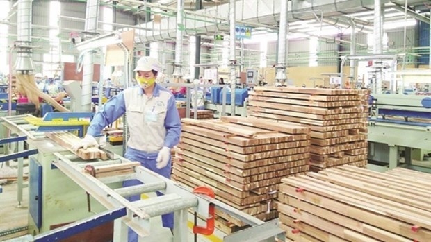
Plan on implementing Decision No. 327/QD-TTG dated March ...
Concretize viewpoints, objectives, tasks and solutions of the plan in accordance with practical conditions of the locality, associating ...Plan on implementing national environmental protection ...
Implementation plan of marine aquaculture development ...
Program on conservation and development of Vietnamese ...
Plan on improving quality of human resources to 2025 and ...
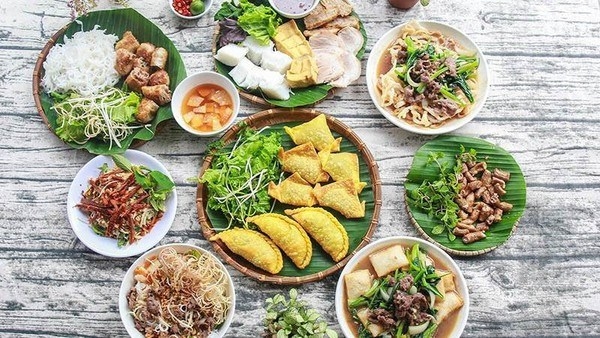
Efforts taken to turn culinary culture into national ...
The Vietnam Cuisine Culture Association (VCCA) is taking steps to implement a project to build and develop Vietnamese culinary culture ...Vietnamese cuisine making a name for itself with ...
Vietnam advance to next round of AFC U20 Women’s Asian Cup
Cultural tourism and traditional values promoted through ...
