


Plan on implementing remote sensing development strategy until 2030, vision to 2040 in Bac Ninh province
Wednesday, July 31,2019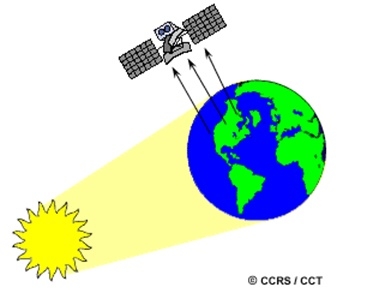
AsemconnectVietnam - Deploy projects and projects on remote sensing technology application, use of products, remote sensing data in sectors and areas, with a focus on basic surveys, monitoring and supervision of natural resources and environment, construction planning, transportation, agriculture and rural development.
I. Objectives
1. General objective
Plan on implementing remote sensing development strategy until 2030, vision to 2040 in Bac Ninh province (hereinafter referred to as the plan to implement remote sensing development strategy) to implement uniformly and applications effective remote sensing activities in sectors and fields serving the tasks of socio-economic development in the province.
2. Specific objectives by 2030
a) Deploy projects and projects on remote sensing technology application, use of products, remote sensing data in sectors and areas, with a focus on basic surveys, monitoring and supervision of natural resources and environment, construction planning, transportation, agriculture and rural development.
b) Develop and update remote sensing database in the province.
c) Train and build remote sensing human resources with professional qualifications to meet the needs of remote sensing technology management, application and development.
d) Promptly issue decisions and regulations on management of remote sensing activities in localities according to the provisions of law.
3. Orientation vision to 2040
To continue promoting and widely applying the use of remote sensing information, data and products in various branches and domains; socializing the application of remote sensing products and technologies. Complete and regularly update remote sensing database, providing timely for sectors and fields for socio-economic development in the province.
II. Main tasks and solutions
1. Organizing to deploy synchronously the tasks of state management on remote sensing
a) Organize the implementation of projects and projects on remote sensing applications within the scope of management.
b) Ensuring technical safety corridors and protecting infrastructure works to receive remote sensing image data under the prescribed management scope.
c) Develop the need to use remote sensing image data under the scope of local management every year, 5 years and according to the unexpected tasks assigned by the State, send to the Ministry of Natural Resources and Environment for synthesis and approval. most admission.
d) Implementing the reception, storage and processing of remote sensing image data under the scope of management.
e) Develop, update and publish remote sensing metadata to meet the requirements of exploitation and use within the scope of local management; provide copies of remote sensing data and image metadata purchased from abroad by the state budget for the Ministry of Natural Resources and Environment to integrate into the national remote sensing image database within the latest 03 month, from the date of receiving data from the supplier.
f) Quality control of remote sensing products, storage and provision of information, remote sensing image data within the scope of local management.
g) To inspect, examine and handle violations in the observance of legal provisions of organizations and individuals participating in remote sensing activities under their management.
h) Annually report to the Ministry of Natural Resources and Environment on the situation of remote sensing activities within the scope of local management.
2. Building remote sensing image database
a) Develop and regularly update remote sensing image database in which high-resolution remote sensing image data is updated annually, super-high-resolution remote sensing image data is updated 5 years once covering the province and annual area for urban areas.
b) Purchasing foreign remote sensing data in case of necessity for socio-economic development.
c) Promote socialization, encourage domestic and foreign organizations and individuals to invest in remote sensing activities in accordance with law.
3. Promote the use of remote sensing information, data and products
a) Provide information, remote sensing data, periodically publish remote sensing metadata.
c) Promote the use of remote sensing information, data and products in sectors and fields.
4. Propagating and disseminating legal documents on remote sensing activities to organizations and individuals in the province
5. Improving capacity, effectively managing remote sensing activities
a) Strengthen the organizational structure and strengthen personnel to perform the task of state management on remote sensing to meet the requirements of remote sensing management.
b) Strengthen training for cadres, civil servants and public servants working in remote sensing management agencies.
c) Investing in facilities, equipment and support tools for remote sensing management agencies.
6. Coordinate with central agencies, professional agencies of the Ministry of Natural Resources and Environment to organize the implementation of provincial remote sensing projects and projects and projects and projects of the Ministry of Natural Resources and Environment. School implemented in the province
III. Organization of implementation
1. Implementation
Based on the contents of the plan for implementing remote sensing development strategy: Departments, departments, branches, People's Committees of districts, towns and cities and relevant agencies and units to implement in time and effective tasks in the Plan, ensuring the actual needs of each industry and field.
2. Assignment of implementation organization
a) Department of Natural Resources and Environment
- Being a standing body The plan for implementing the province's remote sensing development strategy; assume the prime responsibility for implementing the contents of the Remote Sensing Development Strategy implementation plan related to the functions, tasks and powers of the Department of Natural Resources and Environment.
- Prepare and synthesize the results of implementing the Plan for implementing remote sensing development strategy to report to the Provincial People's Committee and the Ministry of Natural Resources and Environment according to regulations.
- Assume the prime responsibility and coordinate in organizing the implementation of projects and projects on remote sensing application in the field of natural resource management, supervision and protection; guide departments, branches and localities to base on the functions and tasks assigned to build and organize the implementation of remote sensing projects and projects to ensure compliance with this Plan.
- Leading and coordinating with the Department of Finance to allocate regular budget for the construction and updating of remote sensing database, in which high-resolution remote sensing image data is updated annually. Super high-resolution remote sensing image data is updated every 5 years to cover the province and annually to urban areas.
- Coordinate with Department of Home Affairs to develop training plans in accordance with the needs of human resource development in the field of remote sensing.
- Actively coordinate and propagate and disseminate legal documents on remote sensing activities in appropriate and effective forms (Post on electronic information portal or integrated in specialized training conferences subjects, law propaganda of the Department).
- Report the results of state management on remote sensing activities in the province to the Ministry of Natural Resources and Environment and the Provincial People's Committee according to regulations.
b) Department of Home Affairs:
Presiding over and coordinating with the Department of Natural Resources and Environment to review and consolidate the organizational structure and arrange sufficient personnel to perform state management tasks on remote sensing.
c) Department of Science and Technology:
Coordinate with Department of Natural Resources and Environment to develop plan and implement researches on remote sensing technology for socio-economic development and defense - security.
d) Department of Agriculture and Rural Development:
Researching and applying remote sensing technology, proposing needs and coordinating to organize the implementation of projects and projects of remote sensing application in the fields of agriculture, forestry, fisheries, irrigation and disaster prevention province.
e) Department of Construction:
Researching and applying remote sensing technology, proposing needs and coordinating to organize the implementation of projects and projects of remote sensing application in planning and monitoring the implementation of urban and rural planning.
f) Department of Transportation:
Researching and applying remote sensing technology, proposing needs and coordinating to organize the implementation of remote sensing projects and projects in transport infrastructure management.
g) Department of Planning and Investment:
Assume the prime responsibility for, and coordinate with the Natural Resources and Environment Services and concerned departments and branches in, allocating public investment capital, encouraging investment resources and actively mobilizing, attracting investment, creating favorable conditions and guide investors in remote sensing in the province.
h) Department of Finance:
Balancing and allocating funds to effectively implement the Remote Sensing Development Strategy according to the provisions of the State Budget Law, the Law on Public Investment and the provisions of relevant laws; guide provincial departments, branches and localities to use funds properly and effectively; appraising, appraising, commenting according to its competence for investment projects on remote sensing managed by the province.
i) People's Committees of districts, towns and cities
Coordinate with relevant departments, agencies, agencies and units in deploying and organizing the implementation of remote sensing projects and projects in the locality.
3. Funding for implementation
b) Based on the assigned tasks, construction agencies and units shall estimate expenditures for implementation of this Plan and integrate them into the annual state budget expenditure estimates and send them to the Natural Resources and Environment Services for summing up. send to the Department of Finance, Department of Planning and Investment to review, synthesize and report to the Provincial People's Committee in accordance with the State Budget Law and current guiding documents.
c) Funds mobilized from other mobilized capital sources.
4. Monitoring and reporting regime
a) Departments, committees and sectors, People's Committees of districts, towns and cities direct and supervise the implementation of this Plan; periodically report on the results of performing assigned tasks; assess the implementation of the Plan for implementation of remote sensing development strategy in the field, local management to send to the Department of Natural Resources and Environment (before November 15 every year) to synthesize and report to the Provincial People's Committee according to regulations determined.
b) Department of Natural Resources and Environment presides to monitor and supervise the implementation of this Plan, periodically (before November 30), annually synthesize and report to the Ministry of Natural Resources and Environment (Remote Sensing Department) national) and the provincial People's Committee on the basis of annual reports (before November 15) on the implementation status of departments, agencies, agencies and relevant agencies.
Long Giang
Source: Vitic / thuvienphapluat.vn
Program on conservation and development of Vietnamese craft villages in a period of 2021 - 2030
Implementation plan of marine aquaculture development project in Ninh Binh province to 2030 with a vision to 2045
Plan on implementing national environmental protection strategy to 2030 with a vision to 2050 in Kien Giang province
Plan on implementing Decision No. 327/QD-TTG dated March 10, 2022 of the Prime Minister approving the project on developing sustainable and effective wood processing industry in the period of 2021-2030 in Gia Lai province
Action plan on implementing strategy of sustainable agricultural and rural development in a period of 2022-2030 with a vision to 2050 in Hanoi city
Plan on implementing Decision No.923/QD-TTG dated August 2, 2022 of the Prime Minister approving science and technology program for new rural construction in a period of 2021-2025 in Vinh Long province
Plan on implementing strategy of sustainable agricultural and rural development in Bac Kan province in a period of 2021 - 2030 with a vision to 2050
Action plan on implementing livestock development strategy in a period of 2022-2030 with a vision to 2045 in Hanoi city
Implementation plan of Vietnam's forestry development strategy for a period of 2021-2030 with a vision to 2050 in Gia Lai province
National master plan in a period of 2021-2030, vision to 2050
Program on strengthening environmental protection, food safety and rural clean water supply in building new countryside in a period of 2021-2025
Digital transformation program on building new countryside, towards smart new countryside in a period of 2021 - 2025
Rural tourism development program on new rural construction in a period of 2021 - 2025
Project on development of trade, e-commerce systems and border trade in Binh Phuoc province in a period of 2021-2025, orientation to 2030

Plan on implementing Decision No. 327/QD-TTG dated March ...
Concretize viewpoints, objectives, tasks and solutions of the plan in accordance with practical conditions of the locality, associating ...Plan on implementing national environmental protection ...
Implementation plan of marine aquaculture development ...
Program on conservation and development of Vietnamese ...
Plan on improving quality of human resources to 2025 and ...

Efforts taken to turn culinary culture into national ...
The Vietnam Cuisine Culture Association (VCCA) is taking steps to implement a project to build and develop Vietnamese culinary culture ...Vietnamese cuisine making a name for itself with ...
Vietnam advance to next round of AFC U20 Women’s Asian Cup
Cultural tourism and traditional values promoted through ...
