


Adjusted, expanded master plan on construction of Nghi Son Economic Zone, Thanh Hoa province to 2035, vision to 2050
Sunday, December 30,2018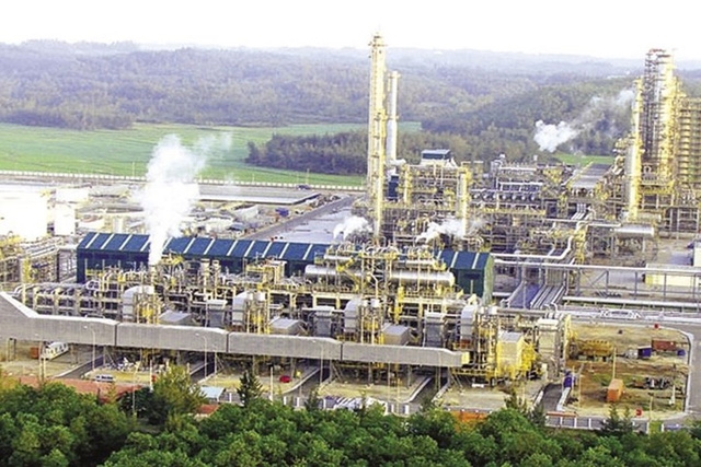
AsemconnectVietnam - It is a multi-sector and multiform marine economic area with a focus on heavy industry and basic industries, closely linking to construction and efficient exploitation of Nghi Son seaport; operating under special preferential arrangements; being driving force for socio-economic development of Thanh Hoa province and northern central region
Scope of planning study includes: whole area of Tinh Gia district (12 communes in older Nghi Son economic area and other communes of Tinh Gia district); 03 communes: Yen My, Cong Binh, Cong Chinh (Nong Cong district) and 03 communes: Thanh Tan, Thanh Ky and Yen Lac (Nhu Thanh district).
Total planning area: 106,000 ha (including 66,497.57 ha of land and islands and 39,502.43 ha of sea surface). Specific boundaries are defined as follows:
- To the north, it borders Quang Xuong district, Thanh Hoa province;
- To the south, it borders on Nghe An province;
- To the east, it border the East sea;
- To the west: Tuong Van, Tuong Linh, Tuong Son, Cong Liem (Nong Cong district); Ben En national park, Phuc Duong commune (Nhu Thanh district), Thanh Hoa province.
- It is a multi-sector and multiform marine economic area with a focus on heavy industry and basic industries, closely linking to construction and efficient exploitation of Nghi Son seaport; operating under special preferential arrangements; being driving force for socio-economic development of Thanh Hoa province and northern central region;
- Being an industrial, service, tourism, synchronous and modern urban complex with a center of Nghi Son industrial city and Hai Ninh, Yen My and Thanh Tan urban centers, which are developed under model of intelligent - green – sustainable urban;
- Being an important traffic hub, a gateway for exchanging goods, connecting northern Laos, northeastern Thailand and neighboring areas of Thanh Hoa with national and international maritime routes via road system and Nghi Son seaport;
- Having an important strategic position on security and defense.
a) Population
- Population forecast to 2025: About 400,000 people, out of which urban population is about 260,000 people;
- Population forecast to 2035: About 500,000 people, out of which urban population is about 420,000 people.
b) Land area for construction up to 2035 includes:
- Industrial, warehouse land area: 9,057.9 ha;
- Port land: About 741.2 hectares;
- Urban land: About 6,012.7 hectares;
- Land for marine tourism, ecological zone: About 6,665.9 ha;
- Land for security and defense: About 411.2 ha;
- Land of religious relics: About 360.5 hectares;
- Land for cemeteries: About 100.0 ha;
- Other technical infrastructure: Approximately 3,708.0 ha.
a) Orientations for spatial development:
Master plan of Nghi Son economic zone is carried out according to area and network as follows:
- To form a network to link urban areas, taking central urban area of Tinh Gia district as a general center of Nghi Son economic zone in association with administrative, educational and industrial functions, R&D activities and urban housing;
- To form two green belts which base on existing forest system in economic zone. The first belt is mountainous area surrounding core zone of economic zone, including former economic zone and central urban area of Tinh Gia; The second belt is hilly area surrounding western and northeastern areas of expanded economy zone;
- To form main urban landscape axis of economic zone in direction of northwest - southeast from mountain peak of Cac Son (the highest mountain in the region) directly linking planned point of the central railway station, towards Me island. Major spaces and urban landmarks are organized around this main axis;
+ Nghi Son port and adjacent areas (including communes of Nghi Son, Hai Ha, Hai Thuong, Hai Yen, Mai Lam, Vinh Hai and Hai Binh): It is a key area for development of Nghi Son economic zone. It focuses on developing heavy industry, supporting industries, crude oil and chemical storage, petroleum, liquefied petroleum gas, seaport, logistics, port logistics and other functions;
+ The southern area (including the communes of Tung Lam, Tan Truong, Truong Lam and Phu Lam): being an area for logistics development, shallow ports, supporting industries, mechanical engineering, construction materials. This is a key area for traffic with national highway 1A, highways, North South railway, station and high speed railway. It is gateway area of Thanh Hoa province and Nghi Son economic zone in the south, forming a regional link with Nghe An province (especially Hoang Mai town);
+ Central urban area (including Tinh Gia township and communes of Ninh Hai, Hai Nhan, Hai Hoa, Binh Minh, Hai Thanh, Nguyen Binh, Xuan Lam and Truc Lam). Being a city center with activities of trade, service, administration - politics, culture - society, etc. To the west of the urban center, developing center for education, training and industry deployment of R & D, hi-tech application;
+ Western area (including communes of Cong Chinh, Cong Binh, Yen My, The Son, Phu Son, Yen Lac, Thanh Tan and Thanh Ky): an area for ecological tourism and entertainment development in association with protection of natural environment of Nghi Son economic zone with a center being Yen My lake in addition to exploiting development of hi-tech industrial parks, renewable energy, clean industry, supporting industries and agricultural and forestry product processing industry…
b) Functional subdivision:
- Space of industrial parks: Total area of industrial land will be about 9,057 hectares by 2035, including: 1,720.0 hectares in northeast region; central urban area is about 781.0 ha; Nghi Son port area is about 2,733.4 ha; southern area is about 1,431.5 ha; western area is about 2,392.0 ha; after 2035, 3,000 hectares of industrial land shall be developed to northwest of Nghi Son economic zone along axis of Tho Xuan air port to Nghi Son economic zone;
- Space of marine tourist resorts and ecological zones: The total land area for development of marine tourist resorts and ecological zones up to 2035 shall be around 6,665.9 ha, including: marine tourism areas of around 432.1 ha, ecotourism zone of about 6,233.9 hectares (including ecological area, theme park, Hao Hao golf lake of about 1,619.0 hectares, Khe Sanh lake ecological area of about 92.7 ha, Bang river ecological zone of about 890.0 ha, Que Son lake ecological area is about 160.0 ha, ecological zone of Nghi Son island is about 126.6 ha, ecological area of Truong Lam forest is about 553.9 ha, ecological area, golf course of Khe Tuan and Kim Giao lake is about 455.0 hectares, ecological area, Yen My lake golf course is about 1,660.0 hectares, Yen My lake tourism service area is about 101.7 hectares, Khe Lau lake ecological area is about 337, 0 hectares, Hon Me island's entertainment area is about 238.0 hectares) and other small tourism destinations with diversified forms such as sea and island tourism, forest ecological tourism, eco-tourism; ...
- Port space: total land area for port development in 2035 is about 741.2 hectares, including: Inland waterway port - northeast area about 6.2 hectares; port - Nghi Son port area is about 735.0 ha.
a) Orientations for traffic plan
- External transport
+ Roads: To upgrade and expand road from Tho Xuan airport to Nghi Son economic zone; Nghi Son - Bai Tranh road; road No.525; road No.512; road No.529; new construction: North-South expressway; coastal road; Road connecting national highway 1A with Tho Xuan airport to Nghi Son economic zone; arranging traffic junctions and routes as required by regulations;
+ Railway: To build a transshipment station in Truong Lam commune, replacing Khoa Truong and Truong Lam stations in conjunction with Depot-ICD and logistics centers; To upgrade and expand Van Trai railway station (in Hai Nhan commune) to become main passenger station in order to meet demand of passenger transport for Nghi Son economic zone; To build a railway linking from cargo terminal at Nghi Son port to transshipment station in Truong Lam commune through Bang Me mountain tunnel, Thung mountain; To build a railway station at a seaport adjacent to container terminal 2; To build a North-South express railway passenger station in Phu Lam commune;
+ Aviation: Using airport in Tho Xuan district, distance to Nghi Son economic zone is about 65 km.
- Internal transport
+ Urban main roads have red line boundaries of 27.0 m ÷ 66.0 m, including: national road No.1A to Nghi Son port; east west Road No.1; road of Hai Hoa - Tho Xuan airport to Nghi Son economic zone; north south No.2 road; Tan Truong - Thanh Tan road; Tan Truong industrial park belt road;
b) Water drainage
- Ground leveling solution: slope of drainage foundation must ensure good surface water drainage; Leveling, digging and embankment for the area is in accordance with principles of local processing in place, balancing excavation in each work. Unstructured areas will retain their natural terrain. For residential areas, situation has been relatively stable, when development of additional intercity construction of additional works or renovation, upgrading the old works need to manage foundation level. Construction foundation must ensure harmony with surrounding area without affecting general water drainage direction of the area;
- Rainwater drainage: Use a separate drainage system, design self drainage to the nearest receiving source; Drainage network spread evenly along road network.
- Total demand for water of Nghi Son economic zone: 385,000 m3/day;
- Water sources: In the first stage, by 2025, demand for water will be 284,000 cubic meters/ day and water will be taken from Muc river, Yen My, Dong Chua, Hao Hao and Cua Dat lakes. Long-term up to 2035, demand for water is 385,000 m3/ day, taken from water resources of Bai Thuong lake, Song Muc, Yen My, Dong Chua, Hao Hao;
- Key works:
+ From now to 2025: To raise capacity of existing clean water plant at Dong Chua lake to 60,000 m3/ day up to 90,000 m3/ day; Clean water plant at Que Son lake with a capacity of 60,000 m3/ day; To build a water plant at Hao Hao lake with a capacity of 105,000 m3/ day; To build Tan Dan water plant with a capacity of 20,000 m3/ day; To upgrade water plant in Thang Tho commune, Nong Cong district (outside Nghi Son economic zone) with a capacity of 15,000 m3/ day and 40,000 m3/ day;
+ From now to 2035, vision to 2050: Upgrading the water plant at Hao Hao reservoir with a capacity of 105,000 m3/ day to 125,000 m3/ day; To upgrade water plant in Thang Tho commune, Nong Cong district with a capacity of 40,000 m3/ day to 80,000 m3/ day; Upgrading water plant in Tan Dan commune with the capacity of 20,000 m3/ day to 30,000 m3/day.
- Pipeline network: To invest in constructing a system of water intake and drainage work from Cua Dat reservoir to Nghi Son economic zone.
- Total electricity demand of Nghi Son economic zone in the first stage up to 2025: Capacity of 1,303.3 MVA; long term until 2035 with vision to 2050: capacity of 2,737.1 MVA;
- Power source: taken from national power system in the Central region, through 500kV and 220kV power grid;
- High voltage grid (220kV and 110kV):
+ 220kV grid: To build a new Nong Cong 220 kV station with a capacity of 2 x 250 MVA; 220 kV station in Nghi Son economic zone with capacity of 2 x 250 MVA; in the 2016-2020 period, a 250 MVA machine shall be installed; In a period of 2021 - 2025, a 250 MVA machine is added; To build a new 220kV transmission line from Nghi Son 500 kV station to 220 kV station of Nghi Son economic zone, AC-2x330 conductor;
+ 110 kV grid: to be sourced from 220 kV stations of Nghi Son economic zone, sub-region of additional load through 110 kV intermediate stations in each deployment stage of economic zone.
- Waste water drainage plan: Total wastewater volume up to 2025: 231,000 m3/ day; Total wastewater volume to 2035: 328,000 m3/ day and night. Sewerage network:
+ Urban daily-life wastewater, independent population clusters and tourism resorts after preliminary treatment by septic tanks shall be brought to concentrated waste water-treating stations for treatment up to prescribed standards before discharging them into environment;
+ Industrial wastewater is preliminarily treated at each factory and then transfer to concentrated waste water treatment stations for treatment. Quality of industrial wastewater after treatment must meet standards prescribed in the national technical regulation on industrial wastewater.
- Solid waste collection and treatment: To expand waste treatment area in Truong Lam commune with a capacity of 2,500 tons/ day for 60 tons of waste to meet the demand for solid waste treatment of Nghi Son economic zone;
- To build and develop communication system of Nghi Son economic zone in synchrony with other infrastructure systems. Technology system, infrastructure, subscriber density ... in line with development of the whole country;
- To continue investing in upgrading technical infrastructure for the State management agencies, administrative and non-business units and a number of other units;
- To complete construction of wide area network, serving well socio-economic activities.
6. Priority programs and projects:
- Industry: To invest in building infrastructures of industrial parks No. 1, 2, 3, 4, 5 and 6 in order to meet demand for industrial land in immediate future; in short term, investing in phase 2 of Nghi Son petrochemical refinery, crude oil and chemical warehouse; To invest in construction of training and research and industrial zones for R&D;
- Tourism: To form tourism service centers in coastal areas from Ghep river to the end of Hai Thanh commune, Bien Son island, Hon Me island; To invest in construction of motive-power project in order to speed up development of Yen My urban center; calling for and attracting investment in tourism projects, golf courses in Yen My lake area and Hao Hao lake; promoting tourism images associated with tours in economic zones and neighboring tourism areas;
+ Seaports: To complete system of seaport technical infrastructures; investing in expanding ports to the north and south; dredging port channels and upgrading Nghi Son jetty to accommodate ships of 70,000 DWT- 100,000 DWT;
+ Railway: To build a new Depots-ICD depot and logistic center in Truong Lam commune to replace Khoa Truong station and Truong Lam station;
+ Roads: To complete coastal road running through Nghi Son economic zone to Nghe An; To build a new road linking national highway No.1A with Tho Xuan airport to Nghi Son economic zone; To build new road from Tho Xuan airport to Nghi Son economic zone directly linking to Nghi Son port under the plan; completing infrastructure system;
+ To invest in construction of concentrated waste water treatment zones for existing Nghi Son economic zone and central urban area; expanding solid waste treatment area in Truong Lam commune; To expand people’s cemetery of Nguyen Binh commune and build a new cemetery of Bom mountain.
Long Giang
Source: thuvienphapluat.vn
Program on conservation and development of Vietnamese craft villages in a period of 2021 - 2030
Implementation plan of marine aquaculture development project in Ninh Binh province to 2030 with a vision to 2045
Plan on implementing national environmental protection strategy to 2030 with a vision to 2050 in Kien Giang province
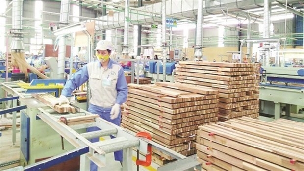
Plan on implementing Decision No. 327/QD-TTG dated March 10, 2022 of the Prime Minister approving the project on developing sustainable and effective wood processing industry in the period of 2021-2030 in Gia Lai province
Action plan on implementing strategy of sustainable agricultural and rural development in a period of 2022-2030 with a vision to 2050 in Hanoi city
Plan on implementing Decision No.923/QD-TTG dated August 2, 2022 of the Prime Minister approving science and technology program for new rural construction in a period of 2021-2025 in Vinh Long province
Plan on implementing strategy of sustainable agricultural and rural development in Bac Kan province in a period of 2021 - 2030 with a vision to 2050
Action plan on implementing livestock development strategy in a period of 2022-2030 with a vision to 2045 in Hanoi city
Implementation plan of Vietnam's forestry development strategy for a period of 2021-2030 with a vision to 2050 in Gia Lai province
National master plan in a period of 2021-2030, vision to 2050
Program on strengthening environmental protection, food safety and rural clean water supply in building new countryside in a period of 2021-2025
Digital transformation program on building new countryside, towards smart new countryside in a period of 2021 - 2025
Rural tourism development program on new rural construction in a period of 2021 - 2025
Project on development of trade, e-commerce systems and border trade in Binh Phuoc province in a period of 2021-2025, orientation to 2030
Plan on implementing Decision No. 327/QD-TTG dated March ...
Concretize viewpoints, objectives, tasks and solutions of the plan in accordance with practical conditions of the locality, associating ...Plan on implementing national environmental protection ...
Implementation plan of marine aquaculture development ...
Program on conservation and development of Vietnamese ...
Plan on improving quality of human resources to 2025 and ...
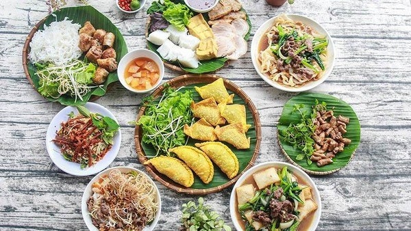
Efforts taken to turn culinary culture into national ...
The Vietnam Cuisine Culture Association (VCCA) is taking steps to implement a project to build and develop Vietnamese culinary culture ...Vietnamese cuisine making a name for itself with ...
Vietnam advance to next round of AFC U20 Women’s Asian Cup
Cultural tourism and traditional values promoted through ...
